Issue Date: Thursday, June 30th, 2022
Issue Time: 10:15 AM MDT
Yesterday was an exciting day all across Northern Colorado. In the early afternoon scattered storms began to fire up in the Northern and Central Mountains before spilling onto the Front Range, Urban Corridor, Palmer Ridge, and Northeast Plains and increasing in coverage and intensity as the day progressed.
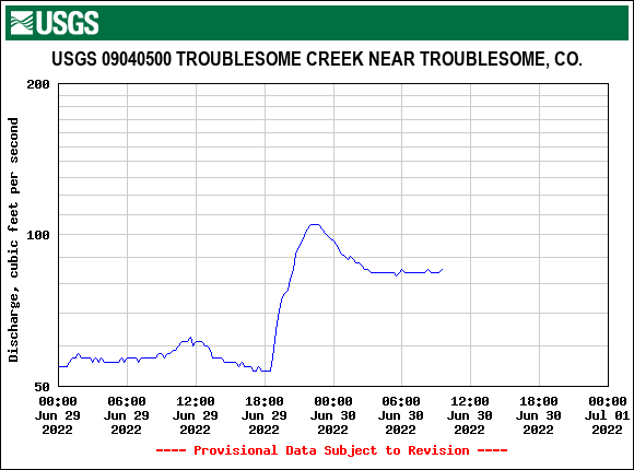
Afternoon and evening thunderstorms with heavy rain prompted several flood advisories to be issued yesterday in the Northern Mountains, particularly for the sensitive Mullen, East Troublesome, and Cameron Peak burn areas. The North Inlet of Grand Lake near the East Troublesome burn scar saw 0.71 inches yesterday at a MesoWest Station, and a CoCoRaHS observer near the Cameron Peak scar reported 0.32 inches as well. Despite the rainfall, thankfully no flooding or debris flows were reported on these scars; though Troublesome Creek saw a sharp rise in discharge from near 50 cfs to over 100 cfs from the rain yesterday, as seen in the hydrograph below.
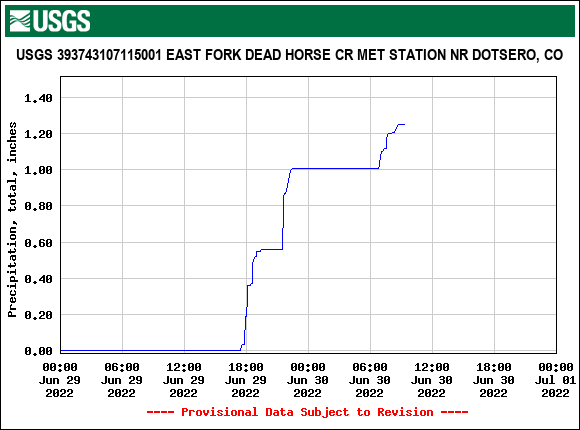
A bit further west, the Grizzly Creek burn scar also saw very heavy rain yesterday. Several USGS gauges east of Glenwood Springs on the scar itself reported near an inch of rain between 6:00 and 10:00 pm, with some rainfall rates as high as 0.10 inches in just 5 minutes. 24-hour totals include:
- 1.24 at East Fork of Dead Horse Creek (hyetograph below)
- 1.19 at No Name
- 0.99 at Cinnamon Creek Complex
A total of 0.57 inches was also reported in Glenwood Springs. However, QPE for this area only shows 0.25-0.50 inches through Glenwood Canyon. The heavy rainfall here also prompted a flash flood warning issued by GJT at 5:36 pm for Grizzly Creek burn area, which then prompted a closure of I-70. Again, there were thankfully no reports of flooding or debris flows on this burn scar from heavy rain yesterday either.
The Urban Corridor, Northeast Plains, and Palmer Ridge were also treated to an exciting evening of widespread storms before dissipating during the overnight hours. These thunderstorms largely produced gusty winds, including a 74-mph gust in Foxfield! Plenty of lightning was also observed with these storms and the #cowx hashtag is full of great shots of storm structure and lightning from yesterday. Rainfall remained modest, largely 0.10-0.20 inches of precipitation has reported by CoCoRaHS observers up and down the Urban Corridor.
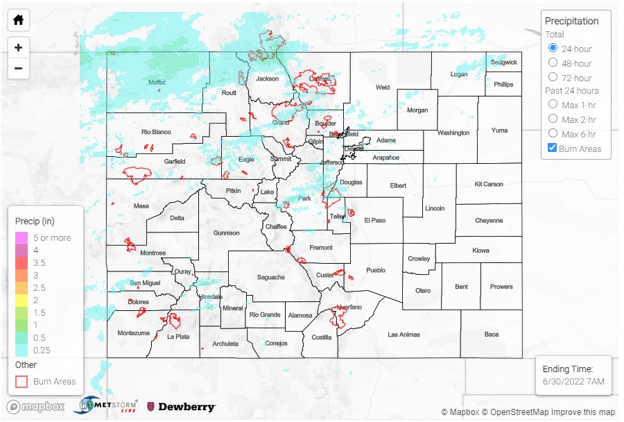
While there was precipitation on the Northwest Slope yesterday, there are little observations to confirm the swath of 0.50 inch precipitation across Moffat, Routt, and Jackson counties, seen in the QPE map below. Some observations in the area include:
- 0.52 in Cowdrey
- 0.36 in Clark
- 0.18 in Craig
Most of Southern and Eastern Colorado remained hot and dry yesterday. Daily high temperatures exceeded 100 degrees near the Nebraska and Kansas borders on the Northeast Plains, and upper 90s for the Southeast Plains. There was no flooding reported yesterday. For precipitation estimates in your area, check out the map below.
Summary:
Note: The Grand Junction radar was down for maintenance until yesterday. This will impact the accuracy of QPE, especially in the southwestern portion of the state.

