Issue Date: Monday, June 27th, 2022
Issue Time: 10:10AM MDT
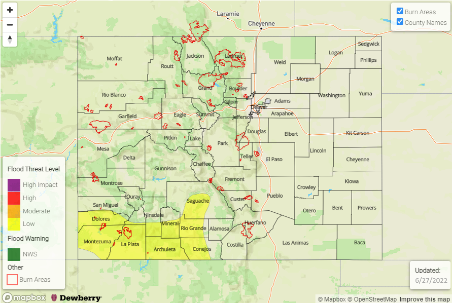
— A LOW flood threat has been issued for portions of the San Juan Mountains and Southwest Slope
— Fire-Burn Forecast Summary: 2 burn areas under LOW threat; click HERE for more info
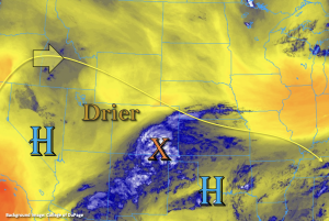
A change in the synoptic pattern will begin today as High pressure begins to build in over the state from the west. More northerly flow aloft will begin to dry out the atmosphere and suppress the subtropical moisture south and eastward by this evening. The beginning of this drying trend can be seen in the water vapor imagery below over northwest and northern Colorado (increase in yellow shades). PW at Denver was measured at 0.71 inches, so it’s already dropping from yesterday. However, for today, the southern tier of the state will continue to be influenced by the High pressure center over Texas with easterly and southeasterly flow aloft forecast. With subtropical moisture, a vorticity maximum and the right entrance of an upper-level jet over southeast Colorado, moderate showers are already occurring this morning. This batch of widespread, light to moderate rainfall is forecast to continue through the mid-afternoon providing more beneficial rainfall to the area as well as cooler temperatures.
A second set of diurnally driven storms is forecast to develop over the mountains this afternoon. As mentioned above, steering flow has changed, so while storms will still be slower moving, expect more SSE storm movement. With drying occurring over north and central Colorado, storms should be more isolated with best coverage over the Front Range. More widely scattered storms and higher local accumulations are forecast over the San Juan Mountains where better moisture will be present. PW over the southwest corner is estimated to be between 0.8 and 0.9 inches this morning with dew points in the 50Fs. While rainfall is not forecast to be as widespread as yesterday, isolated stronger storms may produce heavy, local rainfall over saturated soils. This has the potential to cause mud flows, debris slides as well as excessive runoff over steeper terrains under the stronger storm cores. For these reasons, a LOW flood threat has been issued.
Today’s Flood Threat Map
For more information on today’s flood threat, see the map below. If there is a threat, hover over the threat areas for more details, and click on burn areas to learn more about them. For Zone-Specific forecasts, scroll below the threat map.
Zone-Specific Forecasts:
Northern Mountains, Northwest Slope, Central Mountains, Grand Valley, San Juan Mountains, Southwest Slope, Front Range & San Luis Valley:
Storms will be more isolated north and widely scattered south this afternoon and evening. Isolated max 1-hour rain rates up to 0.3 inches (north), 0.5 inches (central) and 0.9 inches (south) will be possible. Gusty winds will also be possible with storms that develop, especially over north and central Colorado. With slower storm motion, isolated local totals may reach up to 1.2 inches over the San Juan Mountains. Over already saturated soils, mud flows, debris slides and excessive runoff may occur under stronger storm cores that develop today. A LOW flood threat has been issued. The flood threat should end as cooler temperatures take over with the setting sun.
Primetime: 1PM to 9:30PM
Southeast Mountains, Raton Ridge, Southeast Plains, Urban Corridor, Palmer Ridge & Northeast Plains:
Ongoing showers over the Southeast Mountains, Raton Ridge and Southeast Plains will continue through this afternoon. While embedded convection may cause some moderate rainfall rates, flooding is NOT expected. Isolated totals up to 1.5 inches will be possible (east). Additional storms will likely develop over the Southeast Mountains later this afternoon and produce isolated max 1-hour rain rates up to 0.5 inches. Lastly, storms have better potential of spilling into the Urban Corridor today with most rainfall being confined to over or near the elevated ridges. Max 1-hour rain rates up to 0.3 inches (north, Cheyenne Ridge) and 0.5 inches (south, Palmer Ridge) are possible. Flooding is NOT expected.
Primetime: Ongoing to 11PM

