Issue Date: Saturday, June 25th, 2022
Issue Time: 10AM MDT
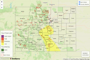
— A LOW flood threat has been issued for the Southeast Mountains, Raton Ridge and portions of the Front Range, Central Mountains and Urban Corridor
— A PM update is possible
— Fire-Burn Forecast Summary: 1 burn area under MODERATE threat; 2 burn areas under LOW threat; click HERE for more info
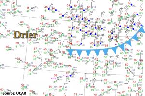
It was pretty easy to draw the cold front on today’s surface map with well-defined northerly winds along and behind it. The front is producing lots of cloud cover and wind over northeastern Colorado with isolated gusts up to 40mph observed over the plains earlier this morning. PW at Denver was measured at 0.69 inches with values reaching up to an inch over the plains. The observed cloud cover should help to keep rainfall chances more isolated north of I-70 this afternoon with the best chance for rainfall over the Front Range. Although, some weak storms may be able to break the cap this evening and produce some light, stratiform rainfall for the I-25 Corridor.
Better instability looks to develop over the southern Front Range/Palmer Ridge intersect and south. With moisture forecast to increase throughout the day from easterly surface flow and some extra mid-level lift arriving from New Mexico, it is possible that a few stronger storms may develop over the area. Slow southeast and east storm motion may allow for an hour up to a few hours of heavy rainfall over the higher terrains late this afternoon through the evening hours. A LOW flood threat has been issued for these reasons. Precipitation will likely continue overnight for high terrains near the southern border and Southeast Plains. While pockets of moderate rainfall will be possible, the lack of instability should limit the convective potential overnight.
Today’s Flood Threat Map
For more information on today’s flood threat, see the map below. If there is a threat, hover over the threat areas for more details, and click on burn areas to learn more about them. For Zone-Specific forecasts, scroll below the threat map.
Zone-Specific Forecasts:
Southeast Mountains, Raton Ridge, Southeast Plains, Front Range, Urban Corridor, Palmer Ridge & Northeast Plains:
Over the northern portion of these forecast zones, isolated rainfall and storms should be mostly confined to the Front Range with max 1-hour rain rates up to 0.5 inches possible. Some lighter showers may be possible over the Urban Corridor tonight with isolated totals up to 0.3 inches possible.
Heavier rainfall will be possible late this afternoon through the evening hours over the southern high terrains. If there are some breaks in cloud cover and decent instability develops (1000 J/Kg of CAPE or so), a couple stronger storms could develop and produce 1-hour rain rates up to 1.25 inches. With slow steering flows and a couple rounds of rainfall forecast, there is also a longer duration flood threat with max 3-hour totals up to 2 inches possible. A LOW flood threat has been issued for the potential of road flooding, low-lying area ponding and mud flows/debris slides over steeper terrains. A PM update will be issued if cloud cover remains persistent, which would limit instability and the threat for stronger storms to develop.
Primetime: 2PM to Ongoing (flood threat ends by late evening)
Northern Mountains, Northwest Slope, Central Mountains, San Juan Mountains, Southwest Slope, Grand Valley & San Luis Valley:
It has dried out quite a bit over western Colorado behind the departing trough, although some residual moisture will likely hang around with only weak westerly flow aloft forecast today. This residual moisture should be enough for some weak storms to develop along and near the Continental Divide this afternoon with better storm chances forecast south over the San Juan Mountains. Max 1-hour rain rates up to 0.6 inches (south) and 0.3 inches (north/central) will be possible. Flooding is NOT expected.
Primetime: 1PM to 10PM

