Issue Date: Wednesday, June 22nd, 2022
Issue Time: 9:50AM MDT
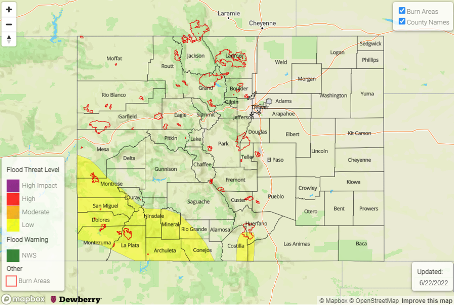
— LOW flood threat has been issued for portions of the Southwest Slope, San Juan Mountains and Southeast Mountains
— The flood threat will persist into the overnight hours
— Fire-Burn Forecast Summary: 1 burn areas under LOW threat; click HERE for more info
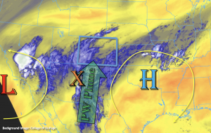
Colorado continues to sit between a cutoff Low to our west and a High pressure system to our east. Southerly flow has helped pull another subtropical moisture plume northward into the state, and this will spread north and eastward today as it rotates clockwise around the High. PW at Denver and Grand Junction was only measured at 0.34 inches this morning with both soundings showing dry mid-levels and limited surface moisture. However, there is a very sharp gradient in PW when moving towards the southern border, and PW at Albuquerque was measured at 1.22 inches! It is likely that PW over the Southeast Plains is also over 1 inch where there are some ongoing light showers this morning. There is also a noticeable mid-level disturbance (orange “X”) moving northwards through the flow, part of which is likely remanent of TC Blas. This, paired with increasing moisture throughout the day, should help spark scattered storms across the southern half of the state by early this afternoon.
 Although it may take a couple hours for the boundary layer to moisten and rain rates to become more efficient, slower steering flows, the possibility of storms anchoring to the mountains and numerous rounds of rainfall should help to increase local accumulations over the southern high terrains. Additionally, a nearly stationary shortwave/trough feature over the Four Corners region tonight will likely sustain and generate more storms across southwest Colorado with some embedded convection possible. So, while the ongoing cloud cover may limit the instability that can build and the flood threat from the 1-hour storm, a LOW flood threat has been issued for longer duration and overnight rainfall accumulation. Mud flows and debris slides will be possible over the steeper terrains as well as an increase in runoff causing rises in local streams and creeks.
Today’s Flood Threat Map
For more information on today’s flood threat, see the map below. If there is a threat, hover over the threat areas for more details, and click on burn areas to learn more about them. For Zone-Specific forecasts, scroll below the threat map.
Zone-Specific Forecasts:
San Juan Mountains, Southeast Mountains, Southwest Slope, Raton Ridge, Southeast Plains & San Luis Valley:
Increasing moisture and mid-level dynamics will cause widespread storms to fire over the high terrains beginning this afternoon and lasting into the overnight hours. Max 3-hour rain rates up to 1.8 inches and 24-hour totals just over 2 inches will be possible. Over the same area that received copious amounts of rainfall this weekend, this may cause mud flows and debris slides over steeper terrains as well as an increase in runoff causing rises in local streams and creeks. A LOW flood threat has been issued that lasts into the overnight hours. Lighter showers will be likely over the mountains tomorrow morning. An isolated area or two of the San Luis Valley could see up to 0.50 inches of rainfall by morning.
Out east, southerly surface winds will help to keep dew points in the 50Fs. If any instability can develop from breaks in the cloud deck later this morning, max 1-hour rain rates up to 1.5 inches will be possible over the Southeast Plains late this afternoon/evening. It is more likely storms will produce 1-hour rain rates up to 0.80 inches later today. Flooding is not expected for this region though nuisance ponding may occur if the higher rain rates are realized.
Primetime: 1PM to 3AM (southwest); 1PM to 8PM (Southeast Mountains)
Northern Mountains, Northwest Slope, Central Mountains, Front Range, Urban Corridor, Palmer Ridge, Northeast Plains & Grand Valley:
More isolated storms are forecast for the southern Central Mountains and Front Range near the Continental Divide. Max 1-hour rain rates up to 0.20 inches will be possible with most storms producing totals under 0.10 inches and only cloud cover. There may be a few sprinkles over the Flat Tops and Roan Cliffs as well. Flooding is NOT forecast for these zones. Afternoon high temperatures will reach into the upper 80Fs across the lower elevations and upper 70Fs for the mountain valleys.
Primetime: 1:30PM to 8PM
