Issue Date: Wednesday, June 22nd, 2022
Issue Time: 11:55 AM MDT
Summary:
Yesterday was similar to Monday, with some rainfall present in the Southern Plains and not much elsewhere. It was also the summer solstice! This is the longest day of the year and first official day of summer- although it may not have felt like it with the cooler temperatures.
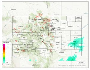
Precipitation totals were generally in the range of 0.10”-0.46”, and most rainfall was observed in our easternmost counties near the borders of Kansas and New Mexico. No thunderstorm or severe weather warnings were issued.
As mentioned before, most of the state was dry- trace to a few hundredths of an inch amounts were observed very sparingly in the Southwest Slope and San Juan Mountains- trace near Pagosa Springs, 0.01” near La Plata, 0.02″ near Durango- but that was about it for precipitation outside the southeast.
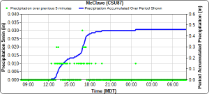
The hyetograph below from McClave, Colorado on the Southeast Plains shows long-duration, low-intensity precipitation starting early yesterday afternoon lasting into the evening, associated with a plume of subtropical moisture. Several CoCoRaHS remarks in the same area observed less, but similar, totals that also reflect the nature of the precipitation, with reports of mist and sprinkles lasting most of the day.
There was no flooding reported yesterday. For precipitation estimates in your area, check out the map below.
Note: Grand Junction and Pueblo radars are down for maintenance. This will impact the accuracy of QPE, especially in the southwestern and southeastern portions of the state.

