Issue Date: June 21st, 2022
Issue Time: 10:10AM MDT
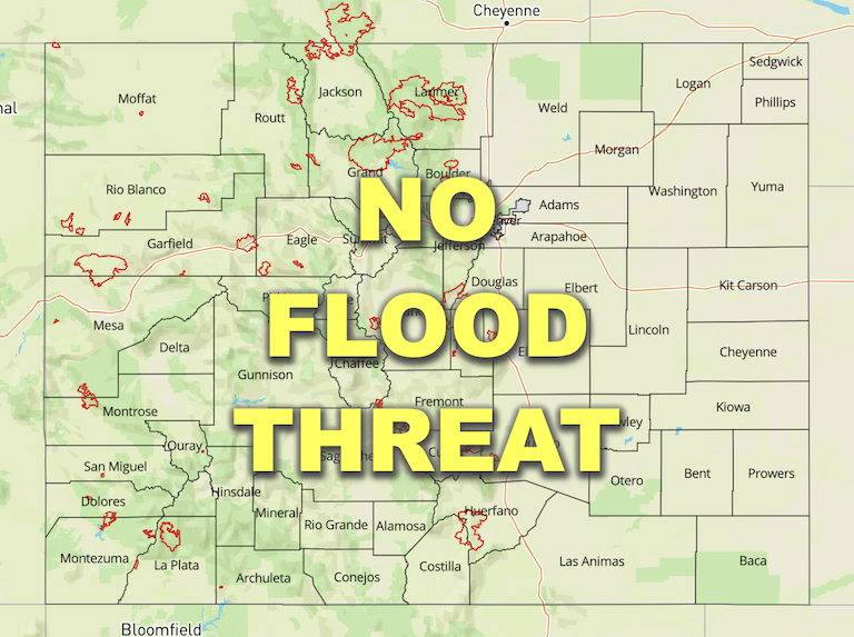
— Flooding is NOT expected today
— A PM forecast update is possible today
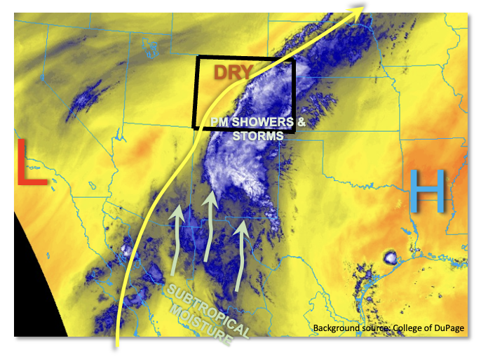
A very interesting weather pattern has developed across the southern Four Corners region. As shown in the water vapor image, below, Colorado is sandwiched between a strong upper-level ridge well to the east and a modest cut-off low pressure over California. The end result is a deep southerly flow that will begin to pump moisture originating from well into the subtropics (or even tropics?!) into our state, at least the southern half of it. To add even more emphasis, there are two tropical disturbances that will help import moisture northward over the next 3-5 days as well. As mentioned in yesterday’s Outlook, this overall pattern may not be a short-term anomaly but instead the predominant flow through most of this week.
But let us not get ahead of ourselves. This morning, most of Colorado remains quite dry. PW at Denver was 0.40 inches, while Grand Junction was even lower at 0.23 inches. Nonetheless, with Albuquerque PW coming in at 0.91 inches, weak southerly flow in the mid-levels of the atmosphere will advect some moisture back into Colorado later today. By late afternoon, we expect PW in the 0.6 – 1.0 inch range along our southern border. Dynamics-wise, a mid-level disturbance with some weak jet-stream support was draped across New Mexico this morning. It shows up well in the water vapor loop below. This feature will trek very slowly northward through the day and will serve as the primary rainfall generation mechanism. A large complex of storms will form over New Mexico later today and move slowly northward. Outflow boundaries could push moist, unstable air into the San Juans before instability wanes around sunset. But at this time, it looks improbable that the heavy rainfall threat will cross into our state as guidance has backed off on rain intensity over the past 24 hours. This is consistent with only marginal instability of perhaps 300-500 J/kg over the southern portion of the San Juan Mountains. Nonetheless, while we do NOT foresee a flood threat at this time, an afternoon update may be required today should moisture and instability trend upward. The San Juan Mountains have received a large amount of rainfall over the past 72 hours so that will promote more effective runoff than normal, should heavy rainfall develop.
Further east, afternoon showers and embedded storms are expected to cross into the Southeast Mountains, Raton Ridge and Southeast Plains. However, with limited instability, sustained but light/moderate intensity rainfall is anticipated and flooding is not expected today.
For the rest of the state, a pleasantly cool and dry Tuesday is in store.
Today’s Flood Threat Map
For more information on today’s flood threat, see the map below. If there is a threat, hover over the threat areas for more details, and click on burn areas to learn more about them. For Zone-Specific forecasts, scroll below the threat map.
Zone-Specific Forecasts:
San Juan Mountains, Southwest Slope, San Luis Valley, Southeast Mountains, Raton Ridge & Southeast Plains:
Increasing clouds and cool with widely scattered showers and storms developing by late afternoon. Highest coverage will be right along the NM border. Max 30-minute rainfall up to 0.5 inches possible, with max 1-hour rainfall up to 0.7 inches mainly over the San Juan mountains. Further east, steadier light/moderate rain showers are expected to develop by mid-afternoon with total accumulation by tomorrow morning up to 0.5 inches possible. Flooding is NOT expected at this time, but an afternoon update may be needed today for the San Juan Mountains.
Primetime (west): 5PM to 11PM
Primetime (east): 2PM into the overnight hours
Northern Mountains, Central Mountains, Grand Valley, Northwest Slope, Northeast Plains, Front Range, Urban Corridor & Palmer Ridge:
Mostly sunny today and seasonably cool today with temperatures running 4-7F below normal. Isolated showers could clip the far southeast portions of the Northeast Plains later today, but rainfall is expected to stay below 0.1 inches.

