Issue Date: Sunday, June 19th, 2022
Issue Time: 10:25AM MDT
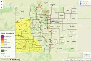
— A LOW flood threat has been issued for the Grand Valley, Southwest Slope, San Juan Mountains and portions of the Central Mountains and Northwest Slope
— Fire-Burn Forecast Summary: 4 burn areas under MODERATE threat, 4 burn areas under LOW threat; click HERE for more info
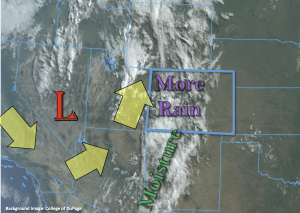
The closed Low has relocated eastward and will continue to move slightly northeast today, which means western Colorado will be under the influence of stronger wind speeds with a more easterly steering component. Thankfully, the plume of moisture will remain overhead, so with the rainfall and cloud cover ongoing and forecast to continue, critical fire weather should remain east of our border. The plume of subtropical moisture is once again marked in the visible satellite imagery below with a significant moisture increase noted in today’s morning sounding at Grand Junction. PW was measured at 0.91 inches, which is around the 95th percentile for this time of year! The dew point has also jumped up to 55°F and much deeper moisture is present within the boundary layer, which should help storms to produce more efficient rainfall rates today with higher accumulations likely over the lower elevation valleys, especially north.
Today is a rinse and repeat pattern with the main area of rainfall forecast to be over western Colorado and the western high terrains with the highest accumulation totals south. Less coverage of storms and lower rain rates are anticipated for the high terrains east of the Continental Divide. Over the last 48-hours, a large portion of the San Juan Mountains has seen 1 to 1.5 inches of rainfall with smaller pockets of these lower-end totals over the Central Mountains. That means soils are likely widely saturated, and rises have already been seen in local creeks and rivers over these areas. With multiple rounds of rainfall forecast today and this evening over that area and meaningful accumulation likely again, there is a better potential for mud flows, debris slides, increased runoff and local creeks running at bankfull conditions. Similar to yesterday, lack of instability (ongoing cloud cover) and quick storm motion should help to limit the flood threat areal coverage, but isolated flash flooding will be possible if any stronger storm cores can develop where there are breaks in cloud cover. These are already occurring over the Grand Valley and northern Southwest Slope. A LOW flood threat has been reissued for the above reasoning.
Over the adjacent eastern plains, surface moisture at Denver is similar to yesterday, which means another day with more of a wind/virga threat than measurable rainfall as storms move off the eastern high terrains with southeasterly steering flow. There are some higher dew points east of the 104°W longitude line, so if a couple storms can make it that far east, more moderate rainfall will be possible. However, flooding is not anticipated for this region.
Today’s Flood Threat Map
For more information on today’s flood threat, see the map below. If there is a threat, hover over the threat areas for more details, and click on burn areas to learn more about them. For Zone-Specific forecasts, scroll below the threat map.
Zone-Specific Forecasts:
Northern Mountains, Northwest Slope, Central Mountains, San Juan Mountains, San Luis Valley, Southwest Slope & Grand Valley:
Another round of widespread rainfall is forecast today with the potential for a few stronger storms to develop where there are breaks in cloud cover. Max 30-minute rain rates up to 0.75 inches will be possible in these areas, and isolated storm totals up to 2 inches possible again over the San Juan Mountains. A LOW flood threat has been issued for isolated flash flooding issues as well as the potential for mud flows and debris slides over the steeper terrains where stronger storm cores or long duration rainfall occurs. A couple showers may continue over the mountains tonight, but the flood threat from rainfall should end as the sun sets.
Primetime: Ongoing to 3AM
Front Range, Southeast Mountains, Urban Corridor, Palmer Ridge, Raton Ridge, Northeast Plains & Southeast Plains:
Scattered afternoon storms are possible over the eastern high terrains this afternoon with an increase in the easterly portion of the steering flow. Max 1-hour rain rates up to 0.75 inches are possible over the moutnains with lesser amounts possible over the immediate adjacent plains. As storms move off the mountains, strong outflow winds will be the main threat. If storms can hold together and make it into the eastern portions of the Northeast Plains/Palmer Ridge/Southeast Plains, max 1-hour rain rates up to 0.6 inches will be possible. The far eastern plains should remain dry, and 25 to 30 mph southerly winds will increase the fire danger over the area.
Primetime: 12PM to 11PM

