Issue Date: Saturday, June 18th, 2022
Issue Time: 10AM MDT
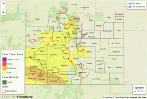
— A MODERATE flood threat has been issued for parts of the Southwest Slope and San Juan Mountains
— A LOW flood threat has been issued for parts of the Front Range, Northern Mountains, Central Mountains, Palmer Ridge, Southeast Mountains and Grand Valley
— Flood threat will persist into the overnight hours
— Fire-Burn Forecast Summary: 5 burn areas under MODERATE threat, 4 burn areas under LOW threat; click HERE for more info
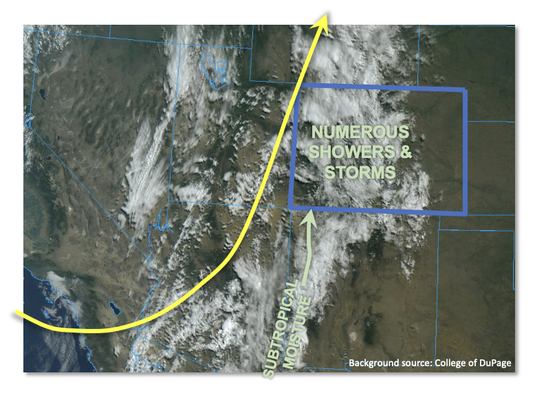
Moisture continues to stream into Colorado from the south, fueled by a somewhat unusual combination of a deep trough to the east and strong subtropical flow originating in Mexico (see visible satellite image, below). Moisture, by any measure, has increased over central and western Colorado since yesterday morning with Grand Junction PW coming in at 0.74 inches. Further south, a nearly saturated Albuquerque sounding showed a PW of 1.10 inches with a dewpoint temperature of 61F! This is the kind of airmass heading into our state today. Instability will also be notably higher than Friday, with CAPE values (briefly) up to 1,200 J/kg possible for far southwest Colorado and more generally in the 400-600 J/kg range further north and east. These are all factors that support a heavy rainfall threat over most of the higher terrain.
There are two main mitigating factors. First, cloud cover, as seen in the satellite image, is fairly expansive so that instability will be come and go today. Second, storm motion will continue to stay on the quicker side, especially towards the WY border. Further south, storm motion is expected to be slower which supports higher rainfall intensity. Nonetheless, a significant increase in shower and storm activity is expected today compared to Friday. The main flood threat will arise from 30-90 minute heavy rainfall that could lead to isolated flash flooding, debris slides and mud flows over most of the higher terrain. This supports a LOW flood threat. However, further southwest, due to higher instability and an expected more rounds of storms, a MODERATE flood threat is warranted as total 24-hour rainfall up to 2.4 inches is possible for parts of the San Juans.
Further east, Denver’s PW this morning was 0.79 inches but boundary layer and total column moisture has actually decreased since yesterday. Additionally, a stronger cap is in place today and will limit precipitation mainly to areas near the foothills. Thus, flooding is not expected.
Today’s Flood Threat Map
For more information on today’s flood threat, see the map below. If there is a threat, hover over the threat areas for more details, and click on burn areas to learn more about them. For Zone-Specific forecasts, scroll below the threat map.
Zone-Specific Forecasts:
Northern Mountains, Northwest Slope, Front Range, Palmer Ridge, Southeast Mountains, Central Mountains, San Juan Mountains, San Luis Valley, Southwest Slope & Grand Valley:
Numerous showers and storms increasing in coverage this afternoon and lasting through the early overnight hours. Max 30-minute rain rates up to 0.8 inches, with max 1-hour rainfall up to 1.2 inches. A LOW flood threat is in effect for most of the area for isolated flash flooding, debris slides and mud flows.
For southwestern areas, storm coverage is expected to be highest leading to max 24-hour rainfall up to 2.4 inches. This will increase the chance for debris slides and mud flows over steeper terrain. Thus, a MODERATE flood threat has been issued here.
Primetime: 11AM through 3AM
Urban Corridor, Raton Ridge, Northeast Plains & Southeast Plains:
Mostly sunny to the east, partly/mostly cloudy to the west with continued warm temperatures of 3-10F above normal. Isolated to widely scattered showers and weaker thunderstorms are expected over the foothills closer to the mountains. Max 1-hour rainfall up to 0.8 inches is possible. However, flooding is NOT expected today.
Primetime: 1PM through Midnight

