Issue Date: Friday, June 17th, 2022
Issue Time: 9:45AM MDT
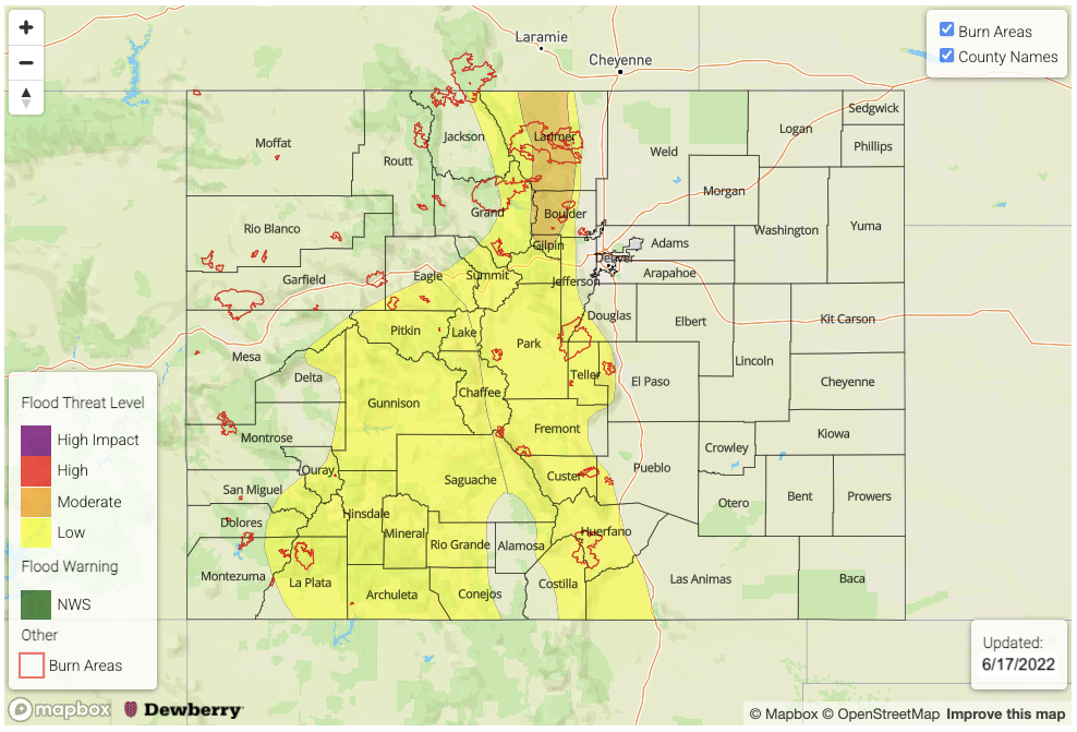
UPDATE (11:50AM MDT): A MODERATE flood threat has now been issued for portions of the Front Range
— A LOW flood threat has been issued for the San Juan Mountains, Central Mountains, Southeast Mountains, Front Range and portions the Northern Mountains and Raton Ridge
— This flood threat continues into the overnight hours
— Fire-Burn Forecast Summary: 3 burn areas under MODERATE threat, 6 burn areas under LOW threat; click HERE for more info
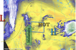
An early season subtropical moisture plume has arrived to western Colorado and the mountains today bringing some much needed widespread rainfall to the area through the weekend, but it also returns the flood threat. As the day continues, the Low will move slightly eastward along the main moisture plume, which is being syphoned northwards from this west coast Low and High pressure system over the Midwest. PW has jumped up to 0.51 inches in Grand Junction with a morning dew point measured at 24°F, and these values should continue to climb with surface moisture deepening over the next 24-hours as evidence by Albuquerque’s 48°F dew point. Equally notable is Denver’s PW morning value, which has increased to 0.83 inches with a dew point measured in the upper 50°Fs.
The jet stream associated with the Low will set up just to our east, which will help provide some extra dynamics for lift and keep storms moving at a quick pace across the state. However, with the abundance of moisture and mid-level energy moving through the southerly flow, numerous rounds of south to north moving storms are forecast to develop over the higher terrains, which will help increase local precipitation totals. This is especially true over south facing slopes. Initially, rain rates will likely be less efficient over the western high terrains due to a drier boundary layer; however, by this evening rain rates have the potential to exceed flood threat criteria. This could cause excessive runoff, mud flows and debris slides over the steeper terrains, so a LOW flood threat has been issued which continues into the overnight hours. Over the eastern mountains, there’s a bit more surface moisture to work with today, which means the storms that develop this afternoon and evening could cause localized flooding issues under the stronger cores. A LOW flood threat has also been issued for this area with the threat of mud flows and debris slides over the steeper terrains.
Out east, it’s going to be a smoky, hot day with a heat advisory issued for portions of the Urban Corridor and Northeast Plains. Due to the more south to north storm motion with the terrain being the driving feature of storm develop, spillover into the adjacent plains should be limited. However, a few showers may reach the I-25 corridor. Flooding is NOT anticipated for this area.
Today’s Flood Threat Map
For more information on today’s flood threat, see the map below. If there is a threat, hover over the threat areas for more details, and click on burn areas to learn more about them. For Zone-Specific forecasts, scroll below the threat map.
Zone-Specific Forecasts:
Northern Mountains, Northwest Slope, Central Mountains, San Juan Mountains, San Luis Valley, Southwest Slope & Grand Valley:
Smoke and widespread rainfall are forecast today. It’s likely that the valleys will stay fairly dry with the main threat from storms tracking off the mountains being lightning and gusty outflow winds. Isolated storm totals up to 0.20 inches will be possible on the outer edges of the valleys. A Red Flag Warning has been issued for the Grand Valley and Southwest Slope for dry lightning and thunderstorm wind gusts increasing fire danger over the area.
Over the elevated terrains, max 1-hour rain rates up to 1.25 inches (south) and 0.75 inches (north) will be possible by this evening, and isolated storm totals by morning over the San Juan Mountains could reach just over 2 inches. A LOW flood threat has been issued for these reasons. Flash flood threats include excessive runoff as well as mud flows and debris slides over the steeper terrains. The flood threat continues overnight, but it should wind down just after midnight with ongoing showers anticipated into tomorrow morning over the Central and San Juan Mountains.
Primetime: 1PM to Ongoing
Front Range, Southeast Mountains, Urban Corridor, Palmer Ridge, Raton Ridge, Northeast Plains & Southeast Plains:
Numerous afternoon thunderstorms and showers are anticipated to fire over the high terrains with better coverage of rainfall north. Max 30-min rainfall rates up to 1.4 inches will be possible, with a max 1-hour rate up to 2.0 inches so a LOW flood threat has been issued. This could cause localized mud flows and debris slides over the steeper terrains under the stronger storm cores as well as excessive runoff. Storms may spill into the adjacent plains, but likely won’t produce much rainfall and should stick areas along and west of the I-25 corridor. Max 1-hour rain rates up to 0.60 inches are possible for this area. A Heat Advisory has been issued for portions of the Urban Corridor and Northeast Plains. More information about this can be found from the NWS Boulder office.
Primetime: 12:30PM to 9:30PM

