Issue Date: Wednesday, June 8th, 2022
Issue Time: 11:15 AM MDT
Summary:
Tuesday was nearly a carbon copy of Monday, as Colorado saw another day of severe weather and heavy rainfall east of the Divide. The axis of the main upper trough responsible for our weather over the last several days passed across the northern Rockies, while an impressive 110 knot jet max progressed from southern Idaho into southern Wyoming during the day. At the surface, broad southeasterly upslope flow led to better moisture and instability compared to Monday, with appreciable moisture reaching as far west as I-25.
A combination of afternoon heating and upper-level energy associated with the wave to our north led to convective initiation by mid-afternoon on the high terrain of the Palmer and Raton Ridges. Environmental parameters favored discrete supercells with this initial round of convection, and storms quickly moved off the high terrain and into the Northeast and Southeast Plains. A secondary round of convection developed later in the evening along the Palmer Ridge before moving into the Southeast Plains; this secondary wave of convection traveled over many of the same areas while growing upscale into a line.
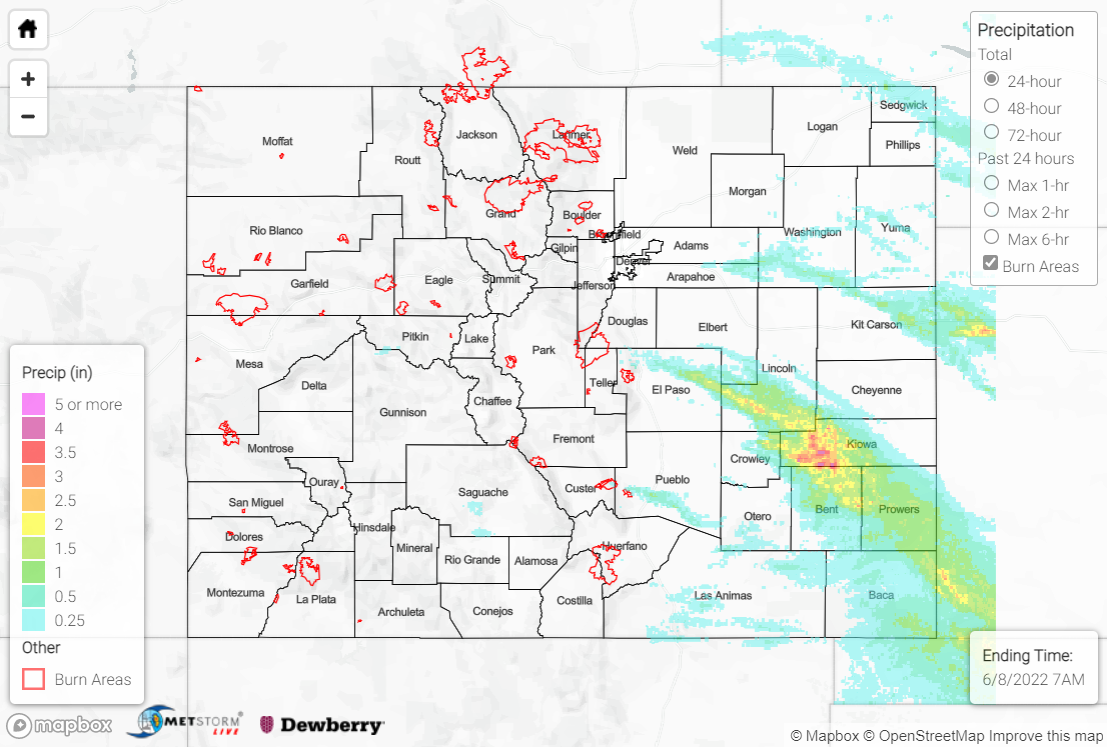
Storms and their associated precipitation were confined to the Northeast Plains, far-southern Urban Corridor, Palmer Ridge, and Southeast Plains, where amounts of 0.50-1.00” were generally observed wherever storms passed. The exception was across southern Lincoln County southeastward into western Kiowa County and Bent and Prowers Counties. In this swath where storms repeatedly passed, the heaviest precipitation in the state was observed, with amounts of 2-3” and localized totals approaching 4+”, per QPE data. Observations are sparse, but some noteworthy reports in this region include:
• 3.00” 3 miles SW of Lamar
• 2.25” 3 miles S of Lamar
• 2.23” at Lamar Municipal Airport
The Pueblo WFO issued another Flash Flood Warning for west-central Prowers County as well as east-central Bent County, including the towns of Lamar, Granada, and Hasty. Local law enforcement reported Main Street in Lamar under 1-2 feet of water! An automated station 3 miles SW of Lamar record 0.98” of rain in just 20 minutes; with rainfall rates of this magnitude, combined with Monday’s rainfall, it does not come as a surprise that flash flooding was observed. The Arkansas River at Lamar is not currently in flood stage, but a sharp rise was observed overnight:
Tuesday saw more intense severe weather than Monday, with 8 tornado reports, 50 hail reports, and 6 wind reports across the state. Of the hail reports, 10 were for significant hail (2+”), including a report of 3.5” hail (nearly softball-sized) 15 miles ENE of Two Buttes! Of the wind reports, 2 were for significant wind (75+ mph), including an 85-mph thunderstorm wind gust 5 miles S of Burlington. The tornado reports were for landspouts in the far northeast corner of the state, and for tornadoes associated with the supercells across the Southeast Plains near Lamar.
The Palmer Divide was a supercell machine yesterday, helping to produce several rounds of severe thunderstorms from early afternoon until well after sunset. The storm structure on a few of them was quite impressive with massive hail cores and localized flash flooding. #cowx pic.twitter.com/c9YcHnDSgq
— Eric Hurst (@WorkingFirePIO) June 8, 2022
The only flooding reported statewide yesterday was in Lamar. For precipitation estimates in your area, check out the map below.

