Issue Date: Wednesday, June 8th, 2022
Issue Time: 10:30AM MDT
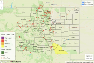
— A LOW flood threat has been posted for parts of the Raton Ridge and Southeast Plains
A complex of storms helped drive a cool front southward across eastern Colorado overnight with temperatures this morning measuring 5-10 F lower compared to yesterday morning. Moisture content has also dropped essentially statewide with morning PW at Denver measuring in at 0.57 inches (right in line with the seasonal normal), but a paltry 0.37 inches at Grand Junction. Most of the state will experience mostly sunny and pleasant weather today with temperatures running a bit below normal over eastern areas and slightly above normal over the western slope.
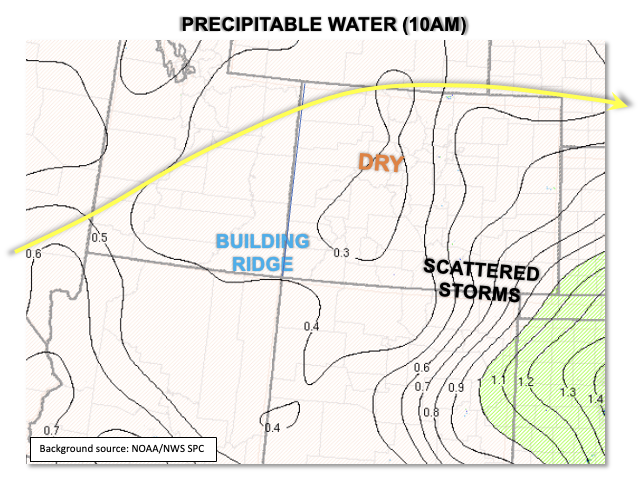
The only area of concern for heavy rainfall today will be over the Raton Ridge and surrounding areas. A strong moisture gradient was noted this morning, as shown in the PW analysis below. Although Denver’s PW is near normal, the PW at Amarillo, TX was an impressive 1.60 inches, a near record level for early June. With a building ridge overhead, steering flow will weaken considerably today compared to yesterday. In turn, this will allow for our normal topographically-driven circulation to take over. Over southeast Colorado, weak northerly flow seen at lower levels this morning will be replaced by upslope east/southeasterly flow this afternoon, allowing the maintenance of dewpoints in the 48F+ range (along with PW of 0.8-0.9 inches). With CAPE instability up to 1,500 J/kg, slow moving storms will be capable of heavy rainfall, albeit with relatively limited duration. Nonetheless, 30-60 minute accumulation potential of 1.2-1.5 inches, respectively, exceeds our flash flood guidance for the region. Thus, a LOW flood threat has been posted for isolated flash flooding, along with debris slides and mud flows over steeper terrain. Storms should dissipate by late evening.
Today’s Flood Threat Map
For more information on today’s flood threat, see the map below. If there is a threat, hover over the threat areas for more details, and click on burn areas to learn more about them. For Zone-Specific forecasts, scroll below the threat map.
Zone-Specific Forecasts:
Raton Ridge, Southeast Plains & Southeast Mountains:
Becoming mostly sunny later this morning, then partly cloudy with scattered showers and thunderstorms expected this afternoon mainly over the Raton Ridge. Max 30-minute rainfall up to 1.2 inches with max 1-hour rainfall up to 1.5 inches possible. Isolated flash flooding, debris slides and mud flows will be possible especially over the steeper terrain. A LOW flood threat has been issued for parts of the area. Hail up to 1 inch will also be possible with the stronger storms.
Primetime: 4PM through 10PM
Northeast Plains, Front Range, Palmer Ridge, Grand Valley, San Juan Mountains, Central Mountains, Northern Mountains, Southwest Slope, San Luis Valley, Southwest Slope & Northwest Slope:
Mostly sunny and pleasant with high temperatures 4-8F below normal east of the Continental Divide and 3-5F above normal west of the Continental Divide. An isolated shower or storm cannot be ruled out over the higher terrain and foothills of the San Juan Mountains, Palmer Ridge and Front Range. However, max 1-hour rainfall only up to 0.3 inches expected. Thus, flooding is NOT expected today.

