Issue Date: Tuesday, June 7th, 2022
Issue Time: 9:30AM MDT
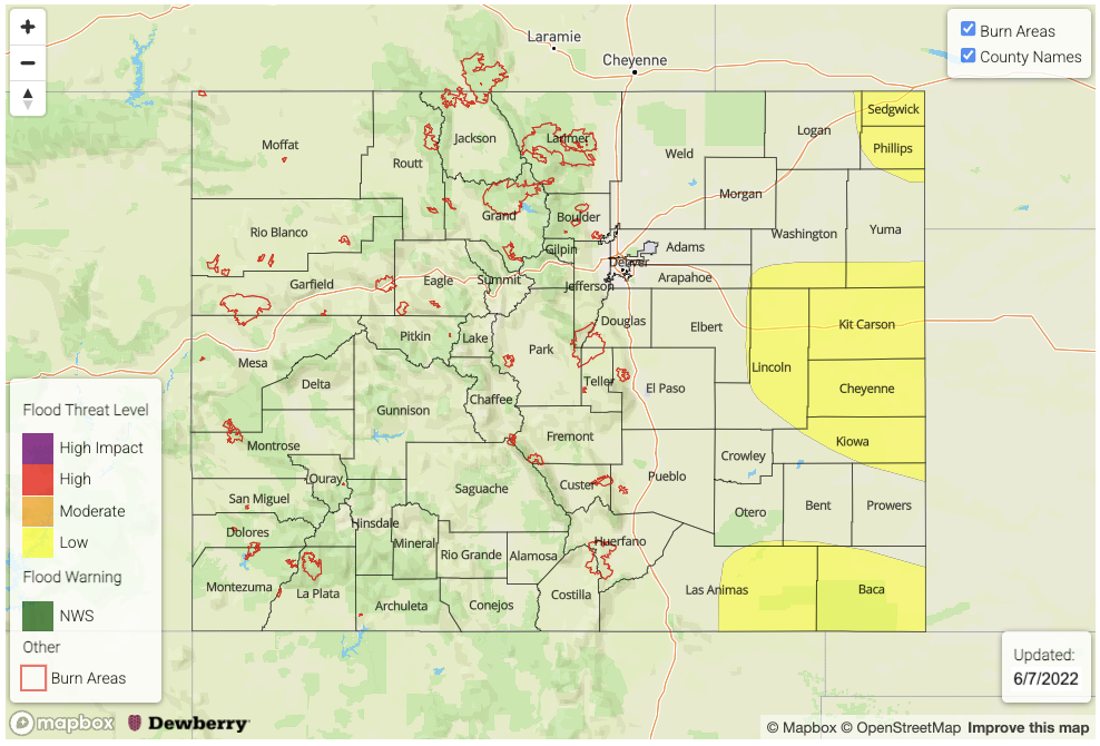
— A LOW flood threat has been issued for portions of the Raton Ridge, Palmer Ridge, Northeast Plains & Southeast Plains
A cold front dropped through the state overnight, which is helping to produce some pockets of cooler morning temperatures and higher surface moisture. This morning, there are some light showers just over the border in Nebraska that are moving east. In their wake, they have left cloud cover and fog over the Northeast Plains, but this should begin to burn off after a few hours of heating. Although today should be a quieter rainfall day in terms of coverage when compared to yesterday, heavy downpours and widely scattered severe thunderstorms are forecast again over the eastern plains this afternoon into the evening hours.
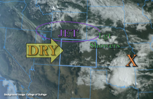
PW at Grand Junction was measured at 0.61 inches, so a slight decrease from yesterday. Over Denver, PW has actually increased to 0.73 inches, which can be witnessed by the cloud deck in visible satellite imagery above from earlier this morning. However, the drier westerly flow and daytime heating is expected to mix out the shallow surface moisture over these areas, which will limit the chances of precipitation out west and over the mountains today. Outside of some weak, isolated showers over the Front Range and Southeast Mountains, it should remain dry with plenty of fair-weather cumulus clouds present this afternoon.
Additional storms are forecast to initiate over the elevated ridges this afternoon and move east where some higher moisture will be present as southeast surface flow resumes. The upper-level jet will continue to sit across the northern border, and it is forecast to dip into the eastern plains this evening. This means a couple things. One is that faster steering flows will be present over northern Colorado again, limiting the flood potential, but also that a stronger thunderstorm could clip the far Northeast Plains later this afternoon. With slower steering flows south and severe thunderstorms ingredients present, heavy rainfall will be likely in the storm cores once again. Therefore, a LOW flood threat has been issued for the area. Similar to yesterday, there is some confidence that a thunderstorm or two may develop over the eastern CO/KS border overnight, so this flood threat continues into the early morning hours.
Today’s Flood Threat Map
For more information on today’s flood threat, see the map below. If there is a threat, hover over the threat areas for more details, and click on burn areas to learn more about them. For Zone-Specific forecasts, scroll below the threat map.
Zone-Specific Forecasts:
Palmer Ridge, Raton Ridge, Northeast Plains & Southeast Plains:
Storms should initiate over the elevated ridges by early afternoon. As they track east, they may become severe with the main threats being large hail (up to 1.75 inches) and strong outflow winds (up to 65 mph), but an isolated tornado cannot be ruled out. In the higher moisture environment, especially with the slower steering flows south, max 1-hour rain rates up to 2 inches could occur. A couple areas (central/south) may see a couple storms track overhead, so isolated storm totals up to 3.5 inches will be possible. A LOW flood threat has been issued for road, low-lying area and local stream/creek flooding possible under the stronger storm cores. A thunderstorm or two could linger into the overnight hours near the KS/CO border, so the threat continues overnight.
Primetime: 2:30PM to 3AM
Southeast Mountains, Front Range, San Juan Mountains, Central Mountains, Urban Corridor, San Luis Valley, Northern Mountains, Northwest Slope, Southwest Slope & Grand Valley:
High-based, isolated storms will be possible for the Southeast Mountains and Front Range. Gusty winds will be more of a threat than rainfall, but max 30-min rain rates up to 0.15 inches will be possible. Otherwise, it should remain dry and warm with broken afternoon cloud cover. Flooding is NOT expected.
Primetime: 1PM to 8PM

