Issue Date: Monday, June 6th, 2022
Issue Time: 3PM MDT
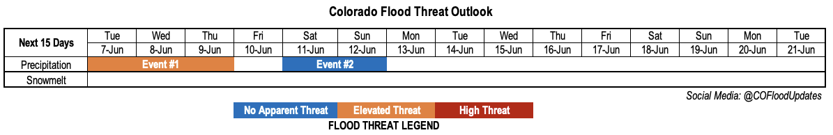
Valid Dates: 6/7-6/21
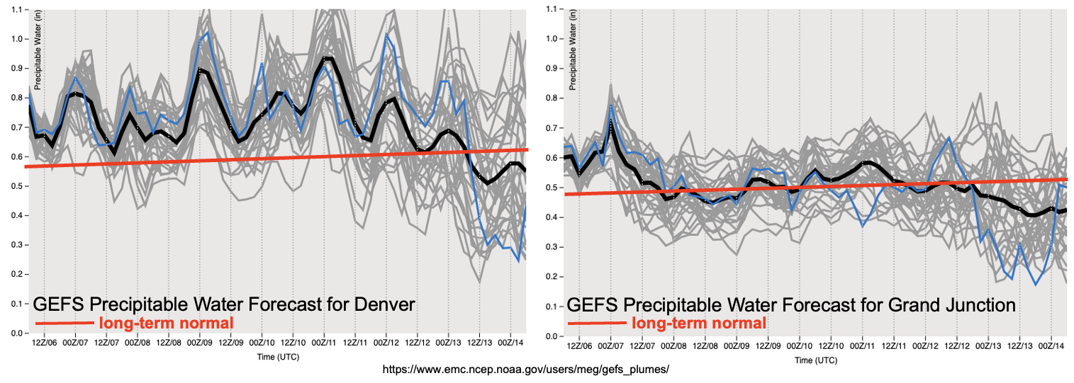
As you have probably heard us say many times, moisture plays a surprisingly large role in dictating our heavy rainfall chances here in Colorado. As shown in the forecast GEFS PW plumes, below, over the next 5 days or so, there will be abundant moisture in place over central and eastern Colorado. PW is expected to range in the 0.7 – 1.2 inch range over the eastern half of the state, which is significantly above normal for early June. An Elevated flood threat is expected, mainly for eastern Colorado, through at least Thursday (Event #1).
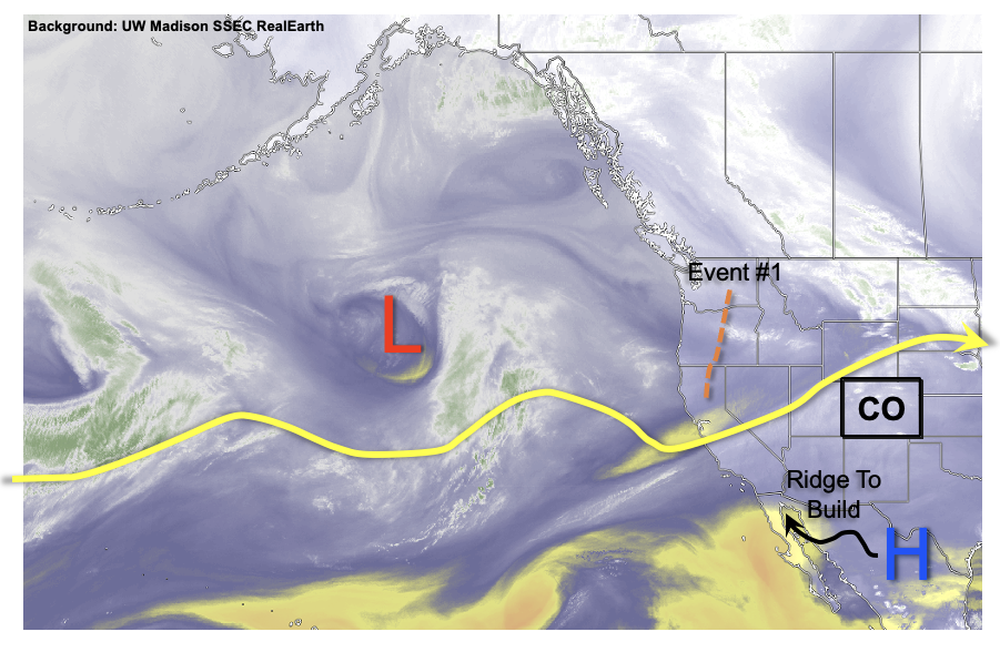
Although we have a good grasp on moisture remaining above normal, the forecast for the atmosphere’s circulation is unfortunately another matter. As shown in this afternoon’s water vapor image, below, while there is a trail of disturbances across the Pacific Ocean, the steering flow is weaker than in recent weeks. This is consistent with summertime dynamics, as we are entering that time of year where the jet stream begins weakening and moving further north. Thus, the strong trough of low pressure over the Gulf of Alaska is actually expected to remain rather stationary over the next 3 – 5 days. Instead, Event #1 will be more dictated by subtler features within the flow over the Rocky Mountains. With plenty of instability daily, at least isolated heavy rainfall and possibly severe weather is a good bet with Event #1.
After Event #1, a few weak fronts are expected to skirt by the eastern border (Event #2), although any meaningful rainfall is expected to stay east of our border. Thereafter, a strong ridge is expected to build over west-central North America, putting Colorado in a favorable position for above normal temperatures. Possibly, much above normal. The prospects of precipitation will depend squarely on moisture availability. With sufficient moisture, our topographically-induced daily circulation can drive its own storm activity. However, at this time, moisture unfortunately looks to be marginal, and meaningful precipitation is not expected through the end of this Outlook at this time.
Before going into the precipitation events, a quick look at the snowpack. Snowmelt has essentially ended for central and southern Colorado. For the North Platte and northern South Platte basins, there is still pockets of high SWE remaining. Melt rates are expected to hover near normal through this week. Melt rates may increase next week with the expected heat wave, but it does not appear that there will be enough remaining SWE to warrant any flooding concerns. Most of the state is expected to be snow free by the end of next week, about 1-2 weeks sooner than normal.
The identified precipitation events are described in more detail below.
Event #1: Tuesday – Thursday (June 7 – June 9)
Elevated Flood Threat, along with severe weather, mainly for southeast Colorado
With plenty of moisture available, daily rounds of scattered storm activity is expected over the eastern Plains. On Tuesday, activity should remain focused along and south of I-70 where max 1-hour rainfall up to 2.0 inches is possible. There is a potential for storm training on Tuesday, with max 3 hour rainfall up to 4 inches possible where storm training occurs. Additionally, with favorable shear profiles, large hail and damaging winds gusts are expected to accompany the strongest storms. A tornado threat will also exist, though mainly along the KS border.
By Wednesday and Thursday, a cool front passage will generally suppress activity over the Northeast Plains. Instead, the focus will shift towards the Southeast Plains, Palmer Ridge and Raton Ridge where adequate instability will fuel scattered storms and support hourly rainfall intensity up to 1.5 inches. Severe weather chances look to diminish somewhat, although the instability will be high enough to warrant at least a slight threat of large hail and possibly damaging. Overall, an Elevated flood threat is expected through this event.
Event #2: Saturday – Sunday (June 11 – June 12)
No Apparent Flood Threat as storms expected to graze Colorado’s eastern border
Western Colorado will begin to dry out and heat up, while a couple of weak cool fronts are possible over the eastern Plains. With moisture generally dropping and ridging overhead favoring subsidence, storm coverage is expected to stay in the isolated to widely scattered range. However, some storms could skirt by the far eastern counties especially over the Northeast Plains. At this time, the flood threat associated with these storms is expected to remain on the Kansas side of the border, and with rainfall expected to stay below 0.5 inches, no precipitation map is warranted.