Issue Date: Thursday, June 2nd, 2022
Issue Time: 3PM MDT
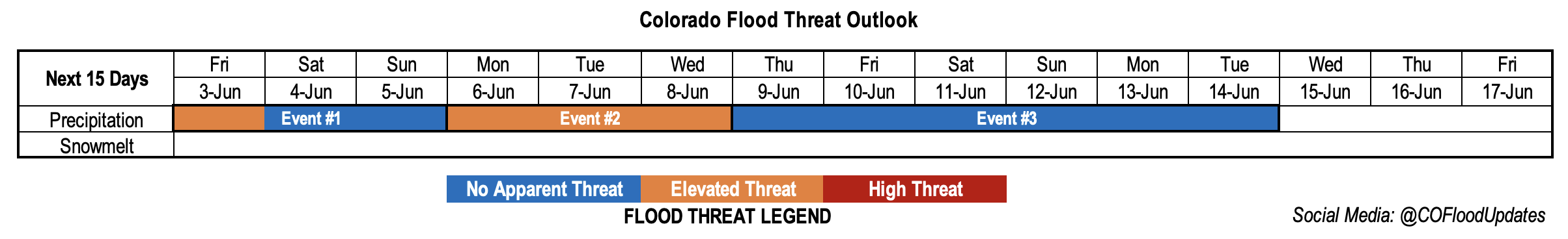
Valid Dates: 6/3 – 6/17
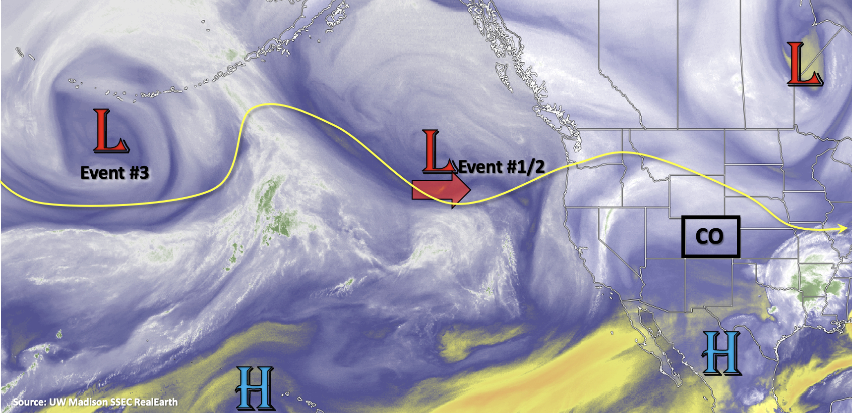
Quite the wave train is shown in the water vapor imagery below, which will translate to a very active rainfall pattern for this outlook, as mentioned on Tuesday. The Low pressure, shown below, will shift slightly east today and spin off the NW coast over the next several days. This is expected to release several shortwaves of various strengths into the westerly flow, which will help produce some stronger thunderstorms and drop a couple cold fronts across the state. Event #1 begins tomorrow with afternoon and evening thunderstorms forecast for the eastern plains. There is a shot for an isolated thunderstorm or two on Saturday afternoon/evening over the far eastern plains, but otherwise it should remain dry to start the weekend. As the upper Low continues to spin over the same area into next week, a larger and slower moving shortwave will be ejected. In tandem with slightly better dynamics, an Elevated flood threat has been issued for Event #2. Finally, by Thursday (start of Event #3), northwesterly flow aloft will return when a strong ridge begins to build over the Great Basin. This setup tends to send plenty of weak disturbances across eastern Colorado with on and off rainfall, but at this time there is No Apparent flood threat.
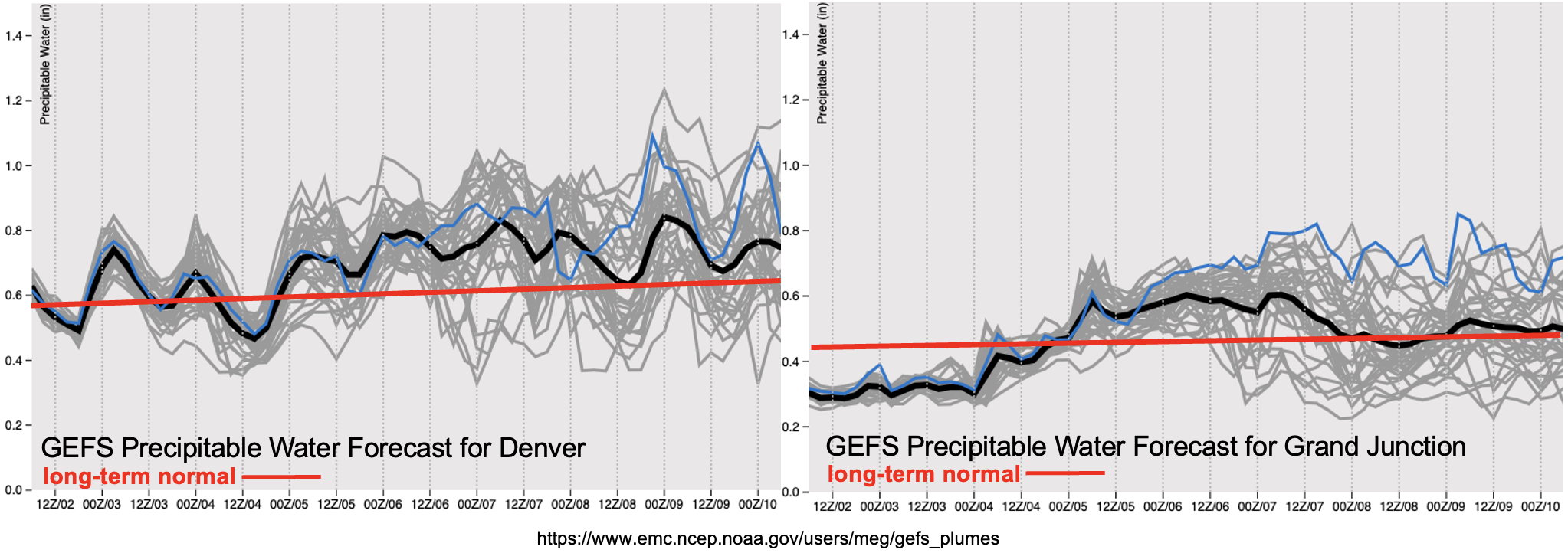
After a quiet April and even May (until the last week or so), it looks like June is going to start off much more active. PW over Denver (left) remains at or above average minus a small dip on Friday night into Saturday morning. While there is still some disagreement between ensemble members (gray lines), it is likely PW will remain elevated into next week, which is another reason that Event #2 received an Elevated flood threat. Even over western Colorado, there is a fairly sharp increase in available moisture as the first shortwave moves across the state, and a cold front helps keep that moisture elevated through mid-week. It’s important to note that there is a strong north to south gradient (high to low) with the moisture return, which indicates that storms will likely be confined to central and northern western Colorado during Event #2. On and off fire danger is expected to continue over the southwest corner through this weekend, although the lack of stronger upper-level winds over the state should make it a less widespread critical fire threat.
Streamflow
Forecasts and observations indicate that the large releases from the Flaming Gorge Reservoir have ended, so expect flows along the Green River to return to normal levels over the next day or two. Outside of a couple isolated events over the next week or so, rainfall isn’t expected over the mountains, so there will be some time for some melt out of the snowpack up north. Not looking at any prolonged period of well above average temperatures over the next week, so this should help temper the melting and subsequent runoff. With the base flows currently on the lower end across northern Colorado, there are not any streamflow highlights for this FTO.
Event #1: Friday – Sunday (6/3 – 6/5)
Elevated flood threat for Friday with severe weather possible out east.
Lee troughing tomorrow and south/southeast surface winds should help pull ample moisture north over eastern Colorado. Storms are expected to initiate over the eastern mountains and elevated ridges by the afternoon. As they move east into this deeper moisture, paired with slower steering flow, the potential for localized flooding issues increase, so an Elevated flood threat has been issued. CAPE, shear and helicity values indicate a couple severe storms could be possible over the plains and eastern Palmer Ridge. These stronger storms may produce large hail, strong outflow winds and perhaps a weak tornado. It’ll be a bit calmer on Saturday behind the passing shortwave, but a stronger storm may clip the far Northeast and Southeast Plains. Lower confidence in this solution, but we’ll be tracking this in the FTB so be sure to check back. Weaker and more isolated storms are forecast over the eastern plains on Sunday, so there is No Apparent flood threat to round out this event.
Event #2: Monday – Wednesday (6/6 – 6/8)
Elevated flood threat as a slower and strong shortwave with aid from upper-level dynamics moves through the state.
It likely won’t be a 3-day period with an Elevated flood threat, but just want to mark a much stronger shortwave and jet moving overhead during this period. These elements should increase the coverage of rainfall each day with measurable rain likely returning to the central and northern mountains as well. Heaviest rainfall is still expected over the far eastern plains, but there’s quite a bit of uncertainty in the location and timing. Depending on when the mid-level energy and an accompanying cold front look to drop through the state (Tuesday into Wednesday), high rain rates and severe weather maybe be possible along Kansas/Colorado border.
Event #3: Thursday – Tuesday (6/9 – 6/14)
No Apparent flood threat as upper-level flow becomes northwesterly.
Bit far out for accurate details, which is why no map has been drawn, but it looks like eastern Colorado will be under the influence of northwesterly flow aloft beginning on Thursday. Through the weekend, a strong ridge begins to build over the Great Basin. This pattern will likely push some shortwaves and cold fronts across the state, which may help initiate some PM thunderstorms. Unsure about moisture during this period, so there will likely be on and off precipitation. The GEFS has also been recently hinting at a large subtropical moisture surge by mid-month, so we’ll be keeping our eye on this as well.