Issue Date: Saturday, May 21st, 2022
Issue Time: 11:05 AM MDT
Summary:
The cold front, which entered the state in the early morning hours yesterday, continued its south-southeast progression across Colorado – bringing plenty of much-needed moisture and some impressive snow totals. Precipitation began in the early morning hours as snow for the high elevations of the Northern Mountains and Front Range, and rain along the Urban Corridor and Northeast Plains. By early afternoon, temperatures continued to cool behind the front enough for a changeover to snow and the beginning of precipitation further south. In fact, some of the most impressive totals from yesterday come from the southern portions of the Front Range, Urban Corridor, as well as the Palmer Ridge. A CoCoRaHS observer in Colorado Springs gave an excellent description of the timing of precipitation throughout the day – their station recorded 2.32 inches of liquid and a foot of snow!
Holy cow. Rain began on Friday May 20th 2022 after 630am and was steady throughout the day. Rain turned to sleet around 4pm and turned to snow by 415pm. By 5pm snow was sticking the ground and clinging to hard surfaces. Branches on the oak snapped by 730pm. More branches down over night. Collection tube had .28 before turning to snow.
For much of the Urban Corridor, Palmer Ridge, and Eastern Plains, temperatures hovered right around freezing or just above, which helped prevent a lot of potential damage and limited snow accumulation once on the ground. Still, some tree damage due to wet heavy snow was reported, like the remark above. Roads largely remained wet as snow easily melted after particularly high temperatures the day before, mostly sticking to grassy or elevated surfaces. Precipitation tapered off in Northern Colorado overnight, while just beginning for portions of Southern and Eastern Colorado. Snowfall totals across the Northern Mountains range between 6-8 inches, while on the opposite end of the state, the Raton Ridge and Southeast Plains, are just seeing the effects of the frontal passage this morning.
Notable Northern Front Range Snow Totals (in inches):
- 12.5 in Genesee
- 10 in Nederland
- 3-8 across Boulder
- 2-4 across Northern Denver Metro
- 5-9 across Southern Denver Metro
Notable Southern Front Range/Urban Corridor, Palmer Ridge, Southeast Plains Snow Totals (in inches):
- 20 inches of snow near Cripple Creek!
- Amounting to 1.76 total liquid, which will certainly be helpful in firefighting efforts on the High Park Fire.
- 19 in Palmer Lake
- 18 in Larkspur
- 13-16 inches between Woodland Park, Black Forest and locations across Colorado Springs, including the Air Force Academy
- Over 11 all the way down to Walsenburg
- 5 in Pueblo West
- Even 6 inches in Limon with almost an inch of liquid equivalent
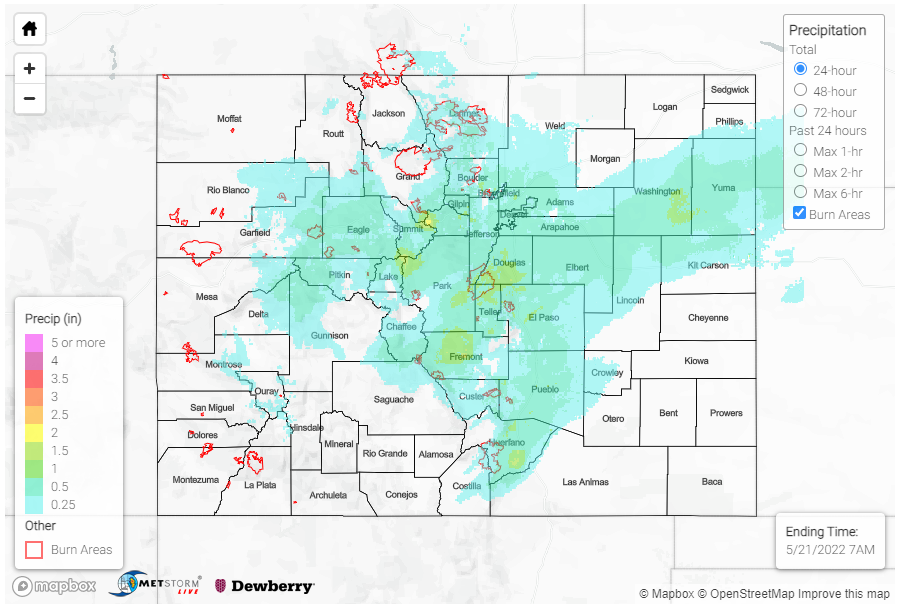
To see how these snowfall totals translate to liquid equivalent precipitation, check out the Quantitative Precipitation Estimates in the SPM below. No flooding was reported yesterday.
Click Here For Map Overview
The map below shows radar-estimated, rainfall gage-adjusted Quantitative Precipitation Estimates (QPE) across Colorado. The map is updated daily during the operational season (May 1 – Sep 30) by 11AM. The following six layers are currently available: 24-hour, 48-hour and 72-hour total precipitation, as well as maximum 1-hour, 2-hour and 6-hour precipitation over the past 24 hour period (to estimate where flash flooding may have occurred). The accumulation ending time is 7AM of the date shown in the bottom right corner. Also shown optionally are vulnerable fire burn areas (post 2012), which are updated throughout the season to include new, vulnerable burn areas. The home button in the top left corner resets the map to the original zoom.
