Issue Date: Friday, May 20th, 2022
Issue Time: 10:20 AM MDT
Summary:
It was a hot and dry one yesterday, with temperatures reaching into the 90s along the Urban Corridor down to the Southeast Plains, and then into the 70s and even some 80s for the Northern, Central, and Southeast Mountains, Palmer Ridge, and Western Slopes. Very high winds moved ahead of the advancing cold front, and coupled with the dry air, Red Flag Warnings were in effect for most of the state yesterday. High winds were reported all across the Western Slopes and Grand Valley, as well as the Eastern Plains along the I-70 corridor near the Kansas border, though it was blustery really everywhere. A 72-mph gust was recorded in Sawpit in San Miguel County and 50-70 mile gusts were reported up and down Western Colorado. On the Eastern Plains, several 50+ mph gusts were reported, and a grassfire was ignited near Wild Horse in Cheyenne County.
Then during the early overnight hours the much anticipated cold-front entered the state from the north, bringing a sharp decline in temperatures and plenty of moisture. For the high elevations of the Northwest Slope, Northern Mountains and Front Range, this came down as very heavy, wet snow. So far this morning over 4 inches of snow has been reported in Steamboat Springs, with up to 0.36 liquid according to CoCoRaHS observers, and it’s still coming down! Scott Longmore shared the following picture on twitter of 4.25 inches of snow near Steamboat. Similar reports on social media show over 2 inches of snow so far in Estes Park and across the Northern Mountains.
4.25” snow 5mi WNW Steamboat II @NWSGJT #COwx pic.twitter.com/HKrdmgS1yH
— Scott Longmore (@ScottLongmore) May 20, 2022
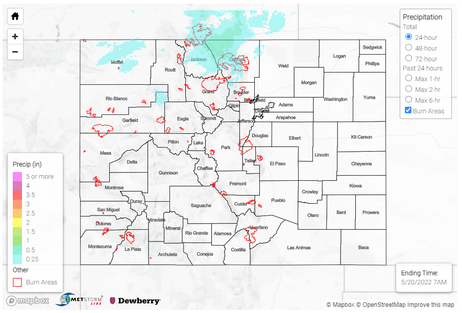
For the Urban Corridor and western portion of the Northeast Plains, rain began around 3 am this morning. Totals as of 7 am are still modest for the northeastern portion of the state, less than 0.25 inches – though it is just the beginning of the storm.
No flooding was reported yesterday. For rainfall estimates in your area, check out the MetStorm Live QPE below.
Click Here For Map Overview
The map below shows radar-estimated, rainfall gage-adjusted Quantitative Precipitation Estimates (QPE) across Colorado. The map is updated daily during the operational season (May 1 – Sep 30) by 11AM. The following six layers are currently available: 24-hour, 48-hour and 72-hour total precipitation, as well as maximum 1-hour, 2-hour and 6-hour precipitation over the past 24 hour period (to estimate where flash flooding may have occurred). The accumulation ending time is 7AM of the date shown in the bottom right corner. Also shown optionally are vulnerable fire burn areas (post 2012), which are updated throughout the season to include new, vulnerable burn areas. The home button in the top left corner resets the map to the original zoom.
