Issue Date: Thursday, May 19th, 2022
Issue Time: 9:45AM MDT
— Flooding is NOT expected today
— Widespread Red Flag Warnings in effect for most of Colorado
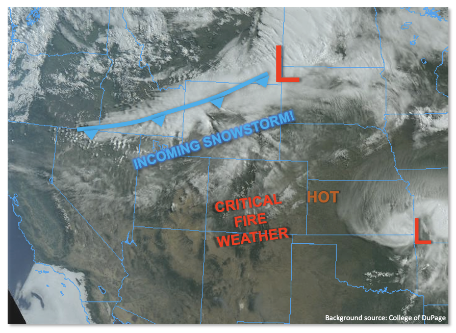
A common saying goes “If you do not like the weather [insert location here], just wait a few minutes”. On a day like today, this saying will be right on point for all of Colorado. As shown in the visible satellite image, below, a strong cold front is currently draped across the Northern Rockies. It will quickly move southward today and enter Colorado early this evening. Behind it, substantial moisture and vigorous dynamics will couple with our unique terrain to provide a powerful May snowstorm for most of the higher terrain and adjacent foothills. However, before we get there, with dry, downsloping winds increasing in strength today, afternoon high temperatures will hit their highest mark of the season for many locations east of the Continental Divide. Now add into the mix very low humidity values, and you guessed it: Red Flag Warnings are widespread today for all but northwest Colorado.
Precipitation will begin as rain below about 11,000 feet today but quickly change to snow. Snow levels will drop all the way to about 6,000 feet by morning. By tomorrow morning, up to 2.25 inches of liquid equivalent is expected over the Northern Mountains! Flooding is NOT expected today.
Flood Threat Map
For more information on today’s flood threat, see the map below. If there is a threat, hover over the threat areas for more details, and click on burn areas to learn more about them. For Zone-Specific forecasts, scroll below the threat map.

Zone-Specific Forecasts:
Northern Mountains, Central Mountains, Grand Valley, San Juan Mountains, Southwest Slope & Northwest Slope:
Increasing clouds and warm today with temperatures 5-12F above normal. Windy conditions will develop by afternoon ahead of the strong incoming cold front, and Red Flag Warnings are in effect for parts of the region. Rain and snow will quickly develop shortly after sunset. Max 1-hour rainfall up to 0.4 inches possible very early in the event before the transition to snow occurs. By tomorrow, up to 2.25 inches of liquid equivalent is expected over the Northern Mountains. However, flooding is NOT expected today.
A few streams in the Northern Mountains (especially the Elk River) are running high. Flows are expected to drop quickly tonight as snowmelt pauses for a few days.
Primetime: 6PM continuing into tomorrow morning
Northeast Plains, Southeast Plains, Front Range, Urban Corridor, Palmer Ridge, Raton Ridge, San Luis Valley & Southeast Mountains:
Partly cloudy with very warm temperatures today, running 10-20F above normal. Windy conditions will develop this afternoon and Red Flag Warnings are in effect. Late in the evening, rain and snow will develop over northern areas and spread south quickly during the overnight hours. Max 1-hour rainfall up to 0.4 inches is possible. Up to 1.4 inches of liquid equivalent is possible over the higher terrain by morning. However, flooding is NOT expected today.
Primetime: 9PM continuing into tomorrow morning