Issue Date: Wednesday, May 18th, 2022
Issue Time: 10AM MDT
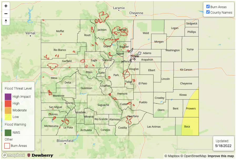
— A LOW flood threat has been issued for the Southeast Plains
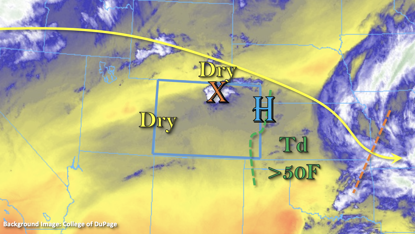
The best moisture and dynamics for storm development will move into southeast Colorado today, and a few severe storms will be possible over the far Southeast Plains late this afternoon and evening. Storms are forecast to develop with upslope flow and a little mid-level energy (orange “X”) over the southern Front Range, Palmer Ridge and Southeast Mountains by early afternoon. As they move off these elevated regions, an incoming trough over the Pacific Northwest will help steering flows gain a bit more of a northerly component. So, expect storms to move ESE at a moderate rate and initially only produce lighter rainfall, wind and a little lightning.
As far as moisture, after the passage of yesterday’s cold front, PW has bounced back to 0.59 and 0.61 inches at Denver and Grand Junction, respectively. At Dodge City, PW was measured just under an inch at 0.92 inches, so a nice gradient, as one would expect, as you move east. There also seems to a weak surface High circulation developing over the eastern border, that will help to produce dry, westerly winds on its north side, and moist, easterly and southeasterly winds on its south side. This should keep dew points in the low 50Fs over the far corner (green dashed line), and may help pull in slightly higher moisture, especially as the diurnal flow kicks in.
As the storms move into this deeper moisture, upscale growth is anticipated, and there is a greater threat for severe thunderstorms to develop. Strong winds will be possible as this occurs along with severe hail and local heavy rainfall. Although the flood threat is on the lower end today, minor road flooding and field ponding will be possible as the storms roll through the far Southeast Plains this evening. Therefore, a LOW flood threat has been issued.
Today’s Flood Threat Map
For more information on today’s flood threat, see the map below. If there is a threat, hover over the threat areas for more details, and click on burn areas to learn more about them. For Zone-Specific forecasts, scroll below the threat map.
Zone-Specific Forecasts:
Front Range, Southeast Mountains, Palmer Ridge, Raton Ridge & Southeast Plains:
Storms will kick off over the southern Front Range, Palmer Ridge, Southeast Mountains and to a lesser extent the Raton Ridge by early afternoon. As storms move into the adjacent plains, they should encounter more moisture, which is when upscale growth is anticipated. Large dew point depressions back to the west mean more of a wind than rain threat, and this wind threat will grow as storms move to the southeast. Severe storms will be likely over the far corner with hail up 1 inch in diameter and gusts up to 65 mph possible, if the storms begin to bow. Max 1-hour rain rates up to 1.75 inches are forecast for the Southeast Plains, which could cause local flooding issues such a minor road flooding and field ponding, so a LOW flood threat has been issued. Over the mountains, isolated totals up to 0.15 inches and over the adjacent plains, max 1-hour rain rates up to 0.50 inches will be possible. So, flooding is not anticipated for these regions.
Primetime: 1PM to 8PM (west); 5PM to 10:30 PM (east)
Northeast Plains, San Luis Valley, Central Mountains, Northern Mountains, Northwest Slope, Southwest Slope, Grand Valley, San Juan Mountains & Urban Corridor:
Isolated storms may develop over the eastern San Juan Mountains and southern Central Mountains with isolated totals up to 0.40 inches (south) and 0.10 (north) possible. Elsewhere, it should remain dry today with 80Fs for the lower elevations and upper 60Fs to low 70Fs for the mountain valleys. Flooding is NOT expected.
Primetime: 1PM to 8PM