Issue Date: Monday, May 16th, 2022
Issue Time: 9:15AM MDT
— Flooding is NOT expected today
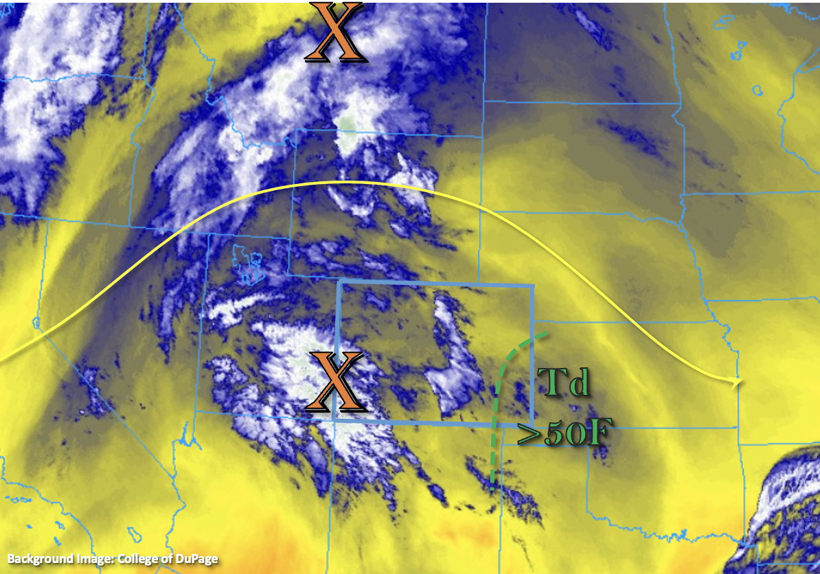
There’s finally some rainfall to forecast today due to a disturbance that has worked its way in from the west under the ridge (orange “X”). This feature will move east today, along with the axis of the ridge, and help to initiate scattered storms over the mountains by early afternoon. These storms are forecast to work their way into the adjacent plains with westerly steering flow aloft late this afternoon into the evening hours. There’s a nice plume of moisture over southeast Colorado shown in the water vapor imagery below (green dotted line), and SSW surface flow is anticipated to turn more southerly throughout the day with a developing surface Low. That means not much moisture advection back to the west, but higher dew points should remain intact over eastern Colorado that could cause some stronger thunderstorms to develop.
PW at Denver and Grand Junction remains about the same as yesterday, 0.36 and 0.35 inches, respectively. The Grand Junction sounding showed this moisture aloft, so it will be too dry to generate storms across the lower elevations. Over the mountains and immediate adjacent plains, expect high-based storms to develop similar to yesterday. A slight increase in dynamics with the mid-level energy should help generate more coverage, although it will still be pretty spotty with only light accumulation forecast. As the storms move east and encounter the weak dryline over the far eastern plains, a couple of severe storms are possible with strong outflow winds and severe hail being the main threats. As for the flood threat, the lack of deeper surface moisture means that the storms will have high bases and likely become outflow driven, which should limit their heavy rainfall potential. Nonetheless, moderate rain rates and much needed rainfall are anticipated under these isolated storm cores. Since storms are not likely to meet flood threat criteria as they quickly move eastward, NO flood threat has been issued.
Today’s Flood Threat Map
For more information on today’s flood threat, see the map below. If there is a threat, hover over the threat areas for more details, and click on burn areas to learn more about them. For Zone-Specific forecasts, scroll below the threat map.

Zone-Specific Forecasts:
Palmer Ridge, Northeast Plains & Southeast Plains:
Expect the highest coverage and strongest storms over these forecast zones today. Over the Palmer Ridge, better moisture will be over the far eastern portion of the forecast zone. As mentioned above, slightly less moisture north than south and west than east. Isolated max 1-hour rain rates up to 1.10 inches (east) and 0.40 inches (west) are possible. Storms will likely produce strong outflow winds today and severe hail may be possible for storms that can make it to the eastern border before instability drops off. Flooding is NOT anticipated at this time.
Primetime: 3PM to 10PM
Front Range, Southeast Mountains, Central Mountains, Northern Mountains & Urban Corridor:
Isolated to scattered, high-based storms are anticipated to develop by early afternoon today favoring the Front Range and areas near and along the Continental Divide (north). A very dry surface layer will increase the wind threat with only limited rainfall forecast. Max 1-hour rain rates up to 0.15 inches are possible with most storms producing under 0.05 inches of accumulation. Flooding is NOT forecast.
Primetime: 1:30PM to 8PM
San Juan Mountains, San Luis Valley, Northwest Slope, Raton Ridge, Grand Valley & Southwest Slope:
Too dry for any rainfall today, but an isolated weak storm may be possible over the San Juan Mountains near the Continental Divide. High temperatures will climb into the mid to upper 80Fs across the lower elevations. A Red Flag Warning has been issued from 12PM to 8PM this evening for the SLV, eastern San Juan and La Garita Mountains as well as portions of the Raton Ridge. Dry southwest winds in the 15 to 25 mph range and gusts up to 35 mph are forecast with relative humidity dropping into the low teens.