Issue Date: Thursday, May 12th, 2022
Issue Time: 9:55AM MDT
— Flooding is NOT expected today
— Widespread Red Flag Warnings in effect
The trough axis is marked as an orange dashed line in the visible satellite imagery below. Throughout the day, this feature is forecast to move to the northeast bringing with it a little mid-level lift and more widespread, windy conditions. As the Low clips the northwest corner of the state, it will likely bring some modest moisture to the area. PW at Denver was measured at 0.39 inches with moisture located at the surface and near 300mb, and some slightly higher dew points were noted in northeast Utah. This should be just enough moisture for some light precipitation to develop this morning and into the afternoon hours over the Northwest quadrant of the state (just south of the Wyoming border). Generally speaking, it is still quite dry over this region, so only scattered, light precipitation is anticipated, and accumulation is most likely over the higher elevations. A weak storm or two may also fire over the Cheyenne Ridge by midday, but northwest steering flow should keep the measurable precipitation north of the state. Flooding is NOT anticipated today.
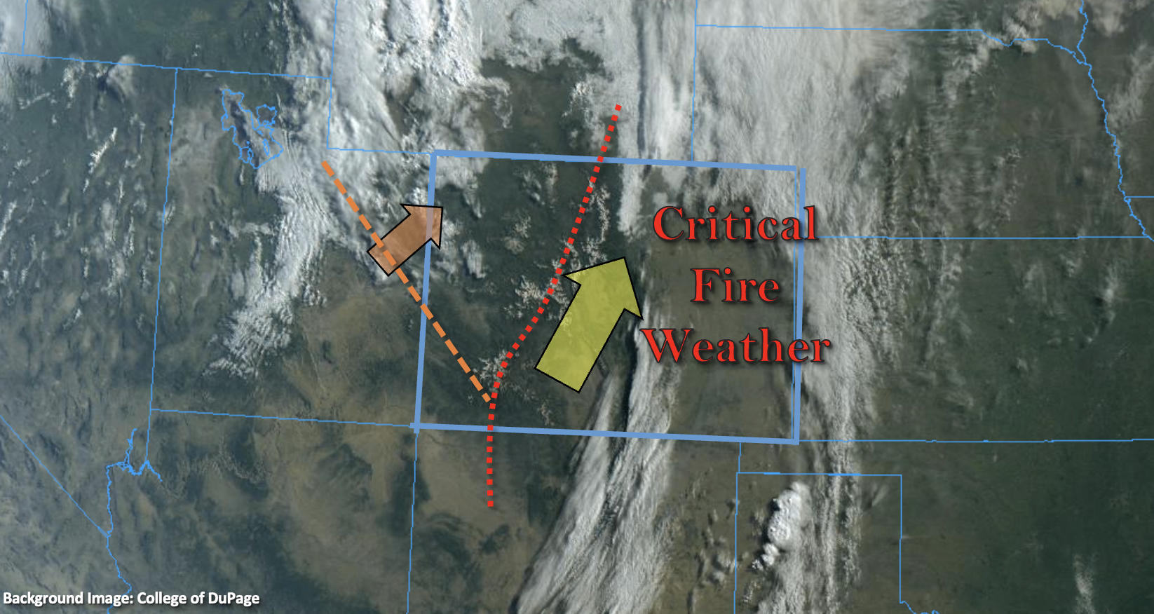
Under the influence of the Low, strong winds and critical fire weather are anticipated once again across large portions of the state. The focus area today will be over areas east of the Continental Divide, associated with the location of the jet. The highest fire danger is forecast east of the dotted red line in image above. A very dry air mass will also be advected into the southwest corner of the state, so although winds will be less today, still use caution with any activities that could produce a spark. The good news is that the wind threat should begin to ease up with the northeasterly movement of the jet by this afternoon. However, a secondary peak in wind speed is forecast tonight, which will likely redevelop windy conditions over the Front Range tonight.
Today’s Flood Threat Map
For more information on today’s flood threat, see the map below. If there is a threat, hover over the threat areas for more details, and click on burn areas to learn more about them. For Zone-Specific forecasts, scroll below the threat map.

Zone-Specific Forecasts:
Northern Mountains, Northwest Slope & Front Range:
Scattered precipitation will likely develop over these regions, just south of the Wyoming border, by mid-morning. Without much moisture to work with, only scattered, light showers are forecast through the afternoon. Isolated max totals just under 0.20 inches will be possible, and high terrains will be favored for accumulation. Flooding is NOT expected.
Very strong winds are forecast to develop over the next hour or two along the Front Range through mid-afternoon, and a Red Flag Warning has been issued. Windy conditions may redevelop over the high peaks of the Front Range overnight.
Primetime: 10AM to 5PM
Southeast Plains, Northeast Plains, Urban Corridor, San Luis Valley, Palmer Ridge, Raton Ridge, Central Mountains & Southeast Mountains:
Dry and windy day ahead. Critical fire weather is forecast for all or portions of these regions this afternoon. Gusts up to 50 mph are possible over the foothills. Paired with dry conditions (remaining surface moisture mixing out), a Red Flag Warning has been issued until 9PM this evening. High Wind Warnings are also issued through noon for El Paso and Huerfano Counties where gusts up to 55mph were already recorded this morning. Since rainfall is not forecast, there is NO flood threat issued. Tune into your local NWS office today for the latest on the fire danger threat.
Grand Valley, San Juan Mountains & Southwest Slope:
Another dry day on tap, but it should at least be less windy. The exception for this will be over the eastern San Juan Mountains this morning where gusts could reach 50 mph. Despite the lack of windy conditions, there are some very low dew points (dry air) that are expected to work their way into the southwest corner with the SSW wind. So, use caution with activities that could cause a spark. Afternoon high temperatures will be more seasonable today with mid to upper 60Fs forecast for the lower elevations.