Issue Date: Tuesday, May 10th, 2022
Issue Time: 6:50AM MDT
— Flooding is NOT expected today
— Widespread Red Flag Warnings in effect
As shown in the water vapor image, below, a strong trough has entered the California coast as of this morning. It is being accompanied by a very powerful jet stream, to the tune of a 160 mph strength, positioned northeastward across the intermountain West. Normally, this would probably be good news for Colorado, as we are beginning to enter our rainy season for the eastern Plains. Unfortunately, that is not the case this time around, as moisture remains lacking across our state. This morning’s PW values are in the 0.2 – 0.4 inch range statewide, compared to a normal value of 0.4-0.7 inches. Thus, we expect dry weather today and flooding is NOT expected.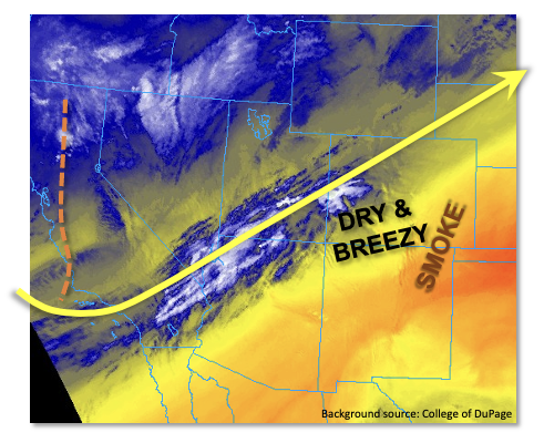
The main impacts from the strong jet stream will be gusty winds once again. Combined with the low moisture content, this has triggered more Red Flag Warnings that cover the central half of Colorado. Additionally, smoke from New Mexico’s three large wildfires will get advected northeast into mainly southeast Colorado this afternoon leading to poor air quality. Incredibly, these three large NM wildfires (Cook’s Peak, Hermit Peak and Cerro Pelado) now exceed a combined 280,000 acres.
Lastly, a quick look at the snowpack shows snowmelt is nearing completion for some of our southernmost basins (notably, the San Juan and Rio Grande rivers) and well underway for other parts of the San Juan Mountains and Central Mountains. With temperatures only slightly above normal today, we do not expect any melt-related flooding issues.
Today’s Flood Threat Map
For more information on today’s flood threat, see the map below. If there is a threat, hover over the threat areas for more details, and click on burn areas to learn more about them. For Zone-Specific forecasts, scroll below the threat map.

Zone-Specific Forecasts:
Northeast Plains, Southeast Plains, Northern Mountains, Front Range, Urban Corridor, Central Mountains & Palmer Ridge:
Mostly sunny early then some high clouds expected during the afternoon. It will be warm with temperatures generally 5-10F above normal, though the far southeast parts of the Southeast Plains will get to 15F above normal (and above 90F). Gusty winds and low humidity has prompted Red Flag Warnings for parts of the region. Smoky conditions are also expected to worsen this afternoon mainly over the Southeast Plains. Flooding is NOT expected today.
Grand Valley, San Juan Mountains, Southwest Slope & San Luis Valley, Northwest Slope, Southeast Mountains & Raton Ridge:
Partly cloudy, windy and seasonably warm with high temperatures about 3-6F above normal. Red Flag Warnings are in effect for the southern parts of the region. Flooding is NOT expected today.