Issue Date: 8/16/2015
Issue Time: 9:30 AM
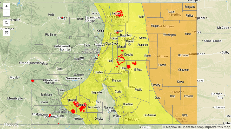
A MODERATE FLOOD THREAT IS FORECAST FOR PORTIONS OF THE NORTHEAST PLAINS, PALMER RIDGE, AND SOUTHEAST PLAINS.
A LOW FLOOD THREAT IS FORECAST FOR PORTIONS OF THE URBAN CORRIDOR, PALMER RIDGE, NORTHERN MOUNTAINS, CENTRAL MOUNTAINS, FRONT RANGE, SOUTHEAST MOUNTAINS, RATON RIDGE, AND SAN JUAN MOUNTAINS.
For today, the main focus will shift to areas east of the mountains as the most active regions due to a passing mid-/upper-level shortwave disturbance. The disturbance will flatten the ridge, cooling temperatures aloft and providing a source of broad-scale thunderstorm support for areas along and east of the Continental Divide. Near the mountains, low-level moisture has been eroded slightly this morning with westerly flow, but should rebound this afternoon as low-level flow turns east-southeasterly once again. The best instability will be in place over the Northeast Plains, Palmer Ridge, and Southeast Plains, with slightly less over the Urban Corridor, Front Range, Raton Ridge, and Southeast Mountains. With the ingredients in place, heavy rainfall will be a threat with thunderstorms, especially considering expected slow storm motions due to weak steering winds aloft. A couple of thunderstorms will become severe, with the main threats being strong winds and large hail, but an isolated tornado cannot be ruled out near the Cheyenne Ridge.
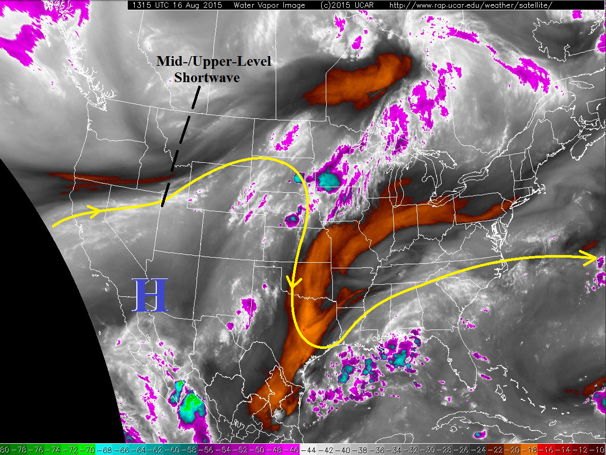
The Northwest Slope, Grand Valley, Southwest Slope, San Juan Mountains, and San Luis Valley will be on the edge of the upper-level support, so terrain-based, isolated-to-scattered thunderstorms will be the main player in those regions. Rain rates will vary, so be sure and check the zone-specific discussions below.
Today’s Flood Threat Map
For more information on today’s flood threat, see the map below (hover over threat areas for more details). For Zone-Specific forecasts, jump below the map.

Zone-Specific Forecasts
Front Range, Urban Corridor, Northeast Plains, Raton Ridge, Palmer Ridge, Southeast Plains, and Southeast Mountains:
Scattered thunderstorms are expected to develop this afternoon, continuing through the evening and into the overnight hours. A few will become severe, mainly across the Northeast Plains and Palmer Ridge regions, producing large hail and strong winds. As stated above, as isolated tornado cannot be ruled out near the Cheyenne Ridge. Maximum rain rates will vary:
Urban Corridor and Front Range: 1.0-2.0 inches/hour
Northeast Plains, Palmer Ridge, and Southeast Plains: 2.2-3.0 inches/hour
Raton Ridge and Southeast Mountains: 0.8-1.4 inches/hour
Timing: Noon – 11 PM, with a few thunderstorms lingering into the early morning hours
Northern Mountains, Central Mountains, San Luis Valley, Northwest Slope, San Juan Mountains, Southwest Slope, and Grand Valley:
Isolated-to-scattered showers and thunderstorms, with the best relative coverage across the Northern Mountains, Central Mountains, and San Juan Mountains. Locally heavy rainfall will be possible across portions of the Northern Mountains, Central Mountains, and San Juan Mountains, and this has been accounted for in the low flood threat area. Maximum rain rates are as follows:
Northern Mountains, Central Mountains, and San Juan Mountains: 1.0-1.5 inches/hour
Northwest Slope, Grand Valley, Southwest Slope, and San Luis Valley: 0.4-0.75 inches/hour
Timing: Noon – 8 PM