Issue Date: Wednesday, May 4th, 2022
Issue Time: 10:30AM
— A LOW flood threat has been posted for parts of the Southeast Plains and Raton Ridge
It seems that Mother Nature flipped a switch on Colorado, going from an ultra dry April to a wet and snowy start to May. Of course, given our historically drought-prone climate, as well as all of the Red Flag Warnings we have endured this spring, it is unlikely that anyone will be complaining!
As seen in the visible satellite image, below, the quick moving disturbance that was forecasted to barrel across the state in Monday’s Flood Threat Outlook, is doing exactly that. However, it is arguably outperforming its earlier forecasts due to the intense dynamics and ability to import at least some modest moisture from the southern Great Plains.
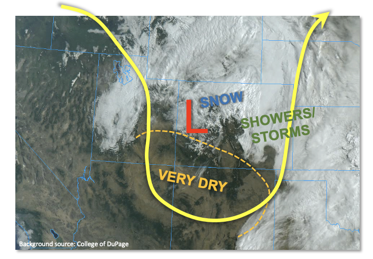
We expect the majority of central and eastern Colorado to experience at least some precipitation today. Two areas, in particular, deserve some more explanation. First, over the northern Front Range, the combination of moist, upslope low-level flow along with frontogenesis will produce a prolonged period of rain and higher-elevation snow, mainly west of I-25. There is no flood threat associated with this as precipitation rates will remain well below key flood thresholds. Second, over the Palmer Ridge, Southeast Plains and Raton Ridge, some early breaks in the clouds will allow convective temperatures to be achieved leading to scattered to numerous showers and thunderstorms during the afternoon hours. The possible formation of a new mesoscale low pressure system over the Arkansas River valley could extend the period of precipitation well into the evening and overnight hours. Instability will not be all that impressive, perhaps up to 800 J/kg of CAPE in parts of the Southeast Plains. However, with strong moisture convergence just north and east of a dryline, training of storms is possible leading to a more prolonged 3-4 hour period of heavier rainfall. Thus, a LOW flood threat of limited extent has been posted for parts of the region for this afternoon and evening. Rain rates will subside shortly after sunset as instability quickly wanes.
Lastly, on a good note, Red Flag Warnings have been lifted today as higher humidity will at least temporarily suppress the wildfire threat. Unfortunately, this looks like a brief respite with very dry conditions returning by Friday.
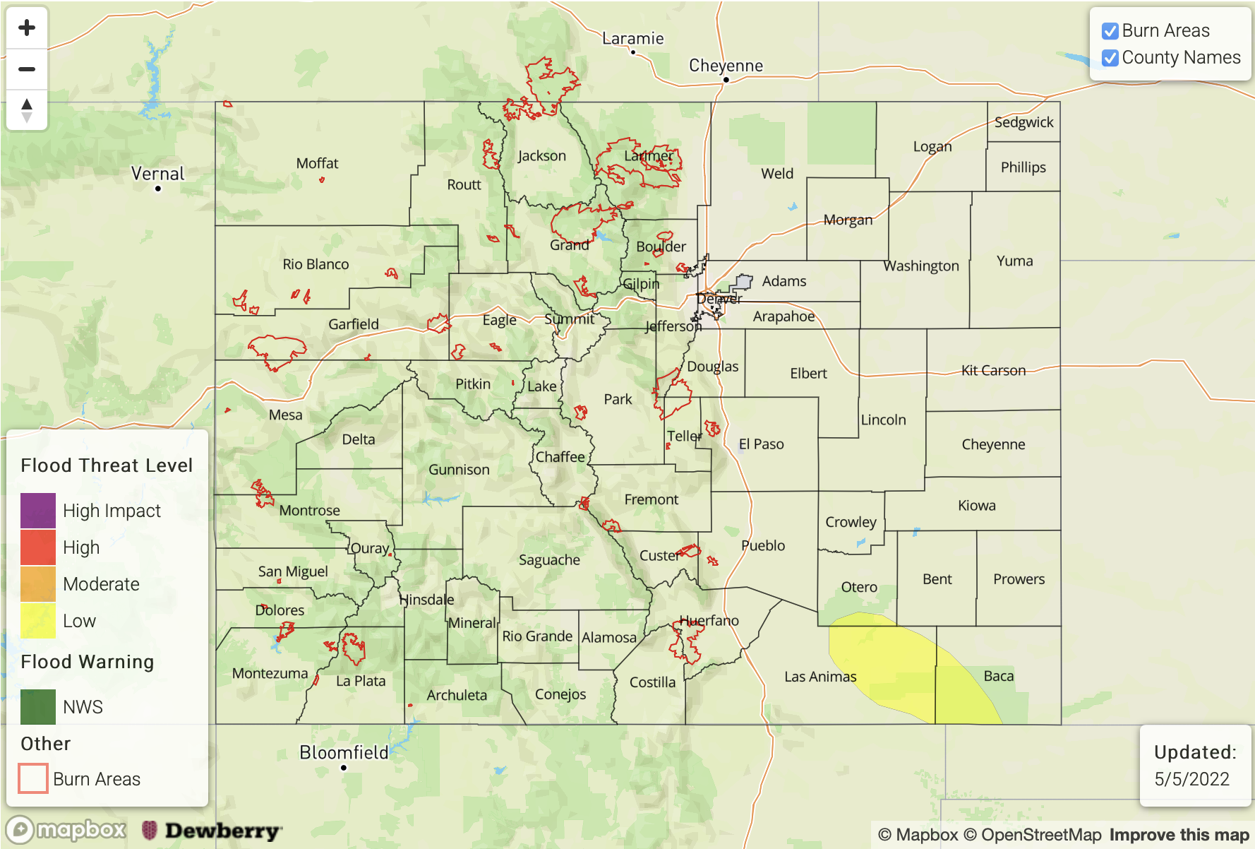
Today’s Flood Threat Map
For more information on today’s flood threat, see the map below. If there is a threat, hover over the threat areas for more details, and click on burn areas to learn more about them. For Zone-Specific forecasts, scroll below the threat map.
Zone-Specific Forecasts:
Raton Ridge and Southeast Plains:
Partly to mostly cloudy with scattered to numerous showers and thunderstorms developing this afternoon. Max 1-hour rainfall up to 1.2 inches with max 3-hour rainfall up to 1.8 inches supports a LOW flood threat for a limited part of the area along the NM border. Isolated flash flooding, debris slides and mud flows will be possible. Hail up to 1.0 inch could also accompany the strongest storms.
Primetime: 3PM to 7PM, then lighter rainfall into the overnight hours
Northwest Slope, Northern Mountains, Central Mountains, Front Range, Urban Corridor, Northeast Plains, Southeast Mountains & Palmer Ridge:
Overcast with scattered to numerous rain and snow showers increasing in coverage this afternoon. The snow level will be in the 7,500 – 9,000 feet level, depending on latitude (lower further north). Thunderstorms, and thundersnow, will also be possible especially east of the Continental Divide. Max 1-hour rainfall up to 0.8 inches will be possible in the lower elevations. Flooding is NOT expected today.
Primetime: Now through 9PM
Grand Valley, San Juan Mountains, Southwest Slope & San Luis Valley:
Becoming partly cloudy with isolated to scattered showers and thunderstorms developing this afternoon. Max 1-hour rainfall up to 0.4 inches. Flooding is NOT expected today.
Primetime: 1PM through 6PM