Issue Date: 8/15/2015
Issue Time: 10:05 AM
A LOW FLOOD THREAT IS FORECAST FOR PORTIONS OF THE PALMER RIDGE, NORTHEAST PLAINS, SOUTHEAST PLAINS, SAN JUAN MOUNTAINS, FRONT RANGE, NORTHERN MOUNTAINS, AND CENTRAL MOUNTAINS.
Another day of isolated-to-scattered showers and thunderstorms is on tap today. Storms will be more numerous over the higher terrain than lower elevations, but regardless of location, all stronger storms will hold the threat of producing locally heavy rainfall. Underneath the upper-level ridge, the large-scale environment is basically neutral for today, but daytime heating will combine with residual moisture to produce thunderstorms, much like yesterday. Also like yesterday, weak steering winds aloft will lead to relatively slow storm motions, providing the opportunity for storms to rain over one location for an extended period of time.
For the lower elevations of eastern Colorado, outflow boundaries from mountain convection will be the main source of forcing for thunderstorms, with a few being the result of strong solar heating. Either way, ample moisture will make heavy rain a threat from any thunderstorm. Other threats include strong winds and lightning, with one or two thunderstorms becoming marginally severe producing wind gusts greater than 55 mph. It looks like the Urban Corridor may be spared the heavy rain threat today, as drier low-level air is in place along the interface with the mountains due to downsloping winds. If the westerly component remains in place through the afternoon, light-to-moderate rain and gusty winds will be all that thunderstorms can muster over the region. For more information on rain rates and timing, please see the zone-specific discussions below.
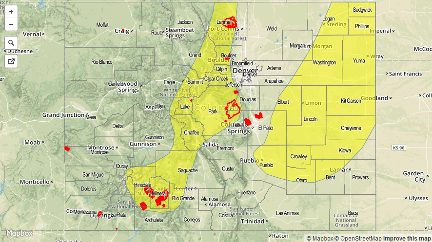
Today’s Flood Threat Map
For more information on today’s flood threat, see the map below (hover over threat areas for more details). For Zone-Specific forecasts, jump below the map.

Zone-Specific Forecasts
Urban Corridor, Northeast Plains, Raton Ridge, Palmer Ridge, and Southeast Plains:
Isolated-to-scattered thunderstorms are expected, with the best coverage over the Palmer Ridge and Southeast Plains regions. Maximum rain rates will vary, so here is the breakdown:
Urban Corridor: 0.4-0.8 inches/hour
Palmer Ridge, Northeast Plains, and Southeast Plains: 1.5-2.5 inches/hour
Raton Ridge: 0.8-1.2 inches/hour
Timing: 1 PM – 10 PM, with a couple thunderstorms lingering until midnight, or just after, across the Plains.
Northern Mountains, Front Range, Central Mountains, San Luis Valley, Northwest Slope, San Juan Mountains, Southwest Slope, Grand Valley, and Southeast Mountains:
Scattered thunderstorms expected over the higher terrain, with more isolated coverage over the lower valleys. The best relative coverage will be over the San Juan Mountains, Central Mountains, Northern Mountains, and Front Range. Maximum rain rates vary:
Northern Mountains, San Juan Mountains, Front Range, and Central Mountains: 0.8-1.4 inches/hour
Southeast Mountains and San Luis Valley: 0.4-0.8 inches/hour
Southwest Slope, Northwest Slope, and Grand Valley: 0.3-0.6 inches/hour
Timing: Noon – 10 PM