Issue Date: 8/14/2015
Issue Time: 9:30 AM
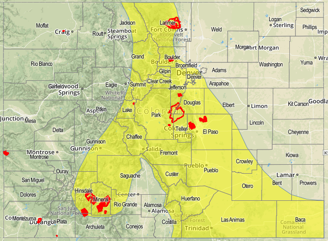
A LOW FLOOD THREAT IS FORECAST FOR PORTIONS OF THE NORTHERN MOUNTAINS, CENTRAL MOUNTAINS, FRONT RANGE, SAN JUAN MOUNTAINS, SOUTHEAST MOUNTAINS, URBAN CORRIDOR, PALMER RIDGE, RATON RIDGE, AND SOUTHEAST PLAINS.
The high pressure ridge will remain anchored over Colorado today, but subtle changes from yesterday will make the difference in today’s forecast. The main difference is that there is really no disturbance expected to track over Colorado. Instead, the main driver behind today’s thunderstorm activity will be daytime heat working on residual moisture under the ridge. Put simply, the activity will favor the higher terrain (especially early in the afternoon), with only a few thunderstorms moving over/developing above the Urban Corridor, Palmer Ridge, and Southeast Plains regions.
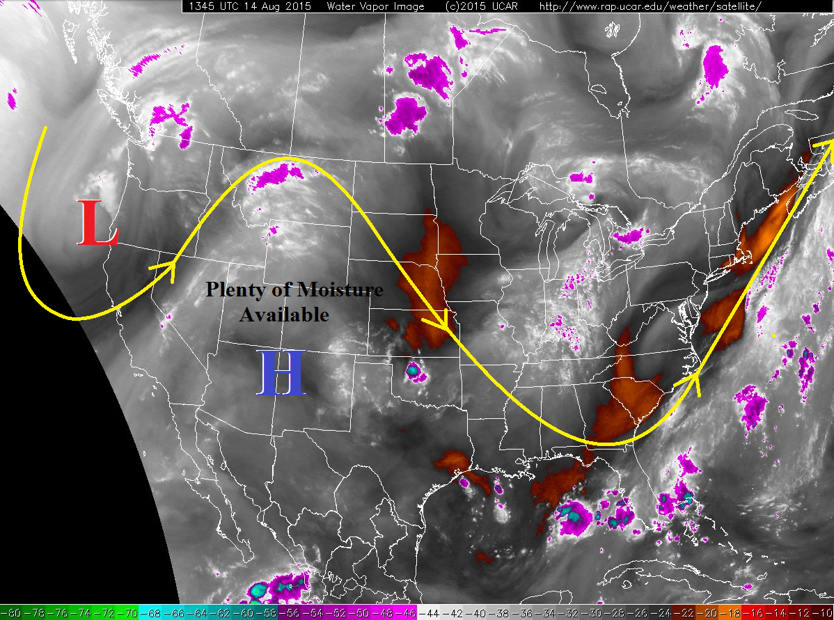
Underneath the ridge, weak flow aloft will allow for slow storm motions. This, combined with precipitable water values near, or above, an inch, will allow for heavy rainfall to impact a localized area for an extended period of time. Tempering the flood threat, though, is that instability is fairly low with warm mid-/upper-levels, so intense convection will be difficult. With all things considered, the low flood threat is warranted. For more details regarding rain rates and timing, please see the zone-specific discussions below.
Today’s Flood Threat Map
For more information on today’s flood threat, see the map below (hover over threat areas for more details). For Zone-Specific forecasts, jump below the map. **OUR MAPPING SERVICE IS EXPERIENCING TECHNICAL DIFFICULTIES THIS MORNING. THE MAP WILL BECOME INTERACTIVE AS SOON AS THEIR ISSUES ARE RESOLVED. WE APOLOGIZE FOR THE INCONVENIENCE.**

Zone-Specific Forecasts
Urban Corridor, Northeast Plains, Raton Ridge, Palmer Ridge, and Southeast Plains:
Isolated-to-widely scattered thunderstorms are expected, mainly near the higher terrain. Further east over the Southeast Plains, a couple of isolated thunderstorms will develop during the late afternoon/evening thanks to outflow boundaries from mountain convection moving into the moist environment. Maximum rain rates will vary…
Northeast Plains: 0.6-1.0 inches/hour
Urban Corridor and Palmer Ridge: 0.8-1.2 inches/hour
Southeast Plains and Palmer Ridge: 1.2-2.0 inches/hour
Timing: 1 PM – 10 PM, with a thunderstorm or two lingering until midnight over the Southeast Plains.
Northern Mountains, Front Range, Central Mountains, San Luis Valley, Northwest Slope, San Juan Mountains, Southwest Slope, Grand Valley, and Southeast Mountains:
Scattered thunderstorms are expected over the higher terrain, with the best coverage expected over the Northern Mountains, Front Range, Central Mountains, Southeast Mountains, and San Juan Mountains. Maximum rain rates will vary…
Northwest Slope, Grand Valley, and Southwest Slope: 0.25-0.5 inches/hour
Northern Mountains: 0.6-1.0 inches/hour
Front Range, Central Mountains, and Southeast Mountains: 1.2-1.8 inches/hour
San Juan Mountains and San Luis Valley: 0.6-1.0 inches/hour
Timing: 11 AM – 10 PM