Issue Date: Wednesday, September 29th, 2021
Issue Time: 10:30AM MDT
— A LOW flood threat has been posted for parts of the Urban Corridor, Front Range and Palmer Divide
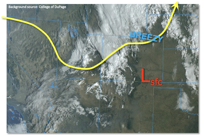
When it comes to analyzing the heavy rainfall threat in Colorado, there are two factors that have significant predictive strength: moisture and dynamics. Very often, only one is present (today, it is dynamics), but in sufficient strength, one can overcome the other’s absence. Such is the case today. As shown in the visible satellite image below, a strong shortwave trough has begun to move into Colorado from the west. In response, a surface low pressure will be developing along the NM/CO border today, responsible for very breezy conditions over the lower elevations of eastern Colorado today. Precipitable Water (PW) at Grand Junction has increased to 0.89 inches this morning, while Denver is steady at 0.67 inches. However, PW is expected to slightly increase today, especially over eastern Colorado. Additionally, the moisture profile has changed to a moister boundary layer over the past 24 hours. This increases chances for moderate to heavy rainfall, especially east of the Continental Divide. The aforementioned surface low pressure will maintain a strong upslope flow east of I-25 over northeast Colorado. With plenty of morning breaks in the cloud cover, there should be enough sunshine to boost instability into the 800-1,000 J/kg range this afternoon. With the stronger dynamics, organization of storms will be likely today, which could lead to prolonged heavy rainfall at a given location. In all, there will be a ~3-5 hour window this afternoon and early evening where heavy rainfall could occur over the Palmer Ridge and surrounding area. A LOW flood threat has been posted for this area.
To the west of the Continental Divide, we expect more light to moderate intensity showers and weaker thunderstorms. Outside of fire burn areas, we do not expect flooding for western Colorado today. The rain/snow line will progress from the 10-11k feet level to 7.5-8.8k feet as colder temperatures aloft move into the state.
Today’s Flood Threat Map
For more information on today’s flood threat, see the map below. If there is a threat, hover over the threat areas for more details, and click on burn areas to learn more about them. For Zone-Specific forecasts, scroll below the threat map.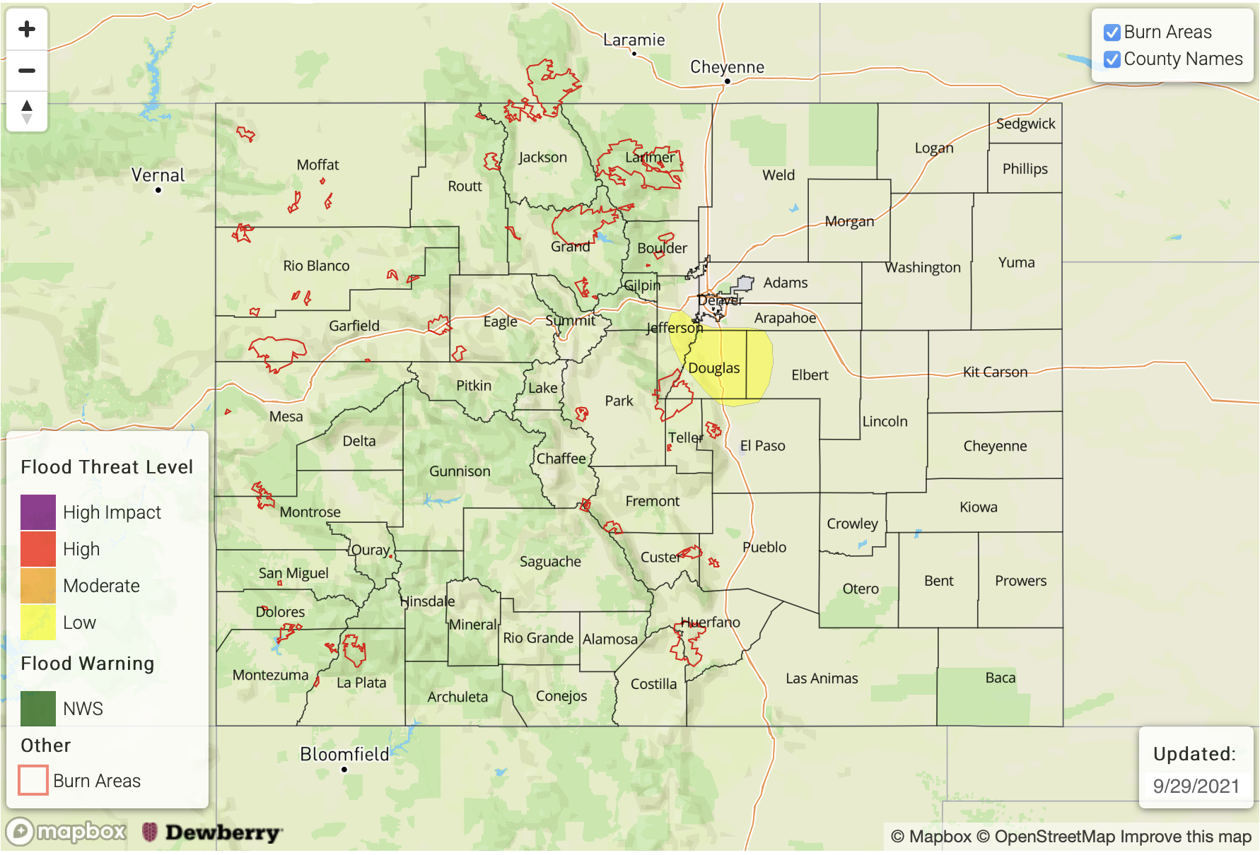
Zone-Specific Forecasts:
Northeast Plains, Southeast Plains, Urban Corridor, Palmer Ridge and Raton Ridge:
Increasing clouds with scattered to numerous showers and thunderstorms developing early this afternoon and persisting into the late evening. Over the Palmer Ridge, max 30-minute rainfall up to 0.8 inches with max 1-hour rainfall up to 1.2 inches possible, and a LOW flood threat has been posted. For other regions, max 1-hour rainfall up to 0.8 inches possible. Hail up to 0.75 inches will be possible with the strongest cells this afternoon
Primetime: 2PM through 10PM
Northwest Slope, Northern Mountains, Front Range, Central Mountains, Grand Valley, Southwest Slope, San Juan Mountains, San Luis Valley and Southeast Mountains:
Mostly cloudy with scattered to numerous showers and weaker storms ongoing throughout the day, then diminishing during the late evening. Max 1-hour rainfall up to 0.8 inches (Front Range) and 0.6 inches (elsewhere). With multiple rounds of precipitation, up to 2.0 inch of total rainfall will be possible especially over the Front Range. Notable accumulating snow will be likely above 10,000 feet, so keep an eye on NWS products and CDOT road conditions.
Primetime: now through 9PM