Issue Date: Saturday, September 18th, 2021
Issue Time: 9:20AM MDT
— Flooding is NOT expected today
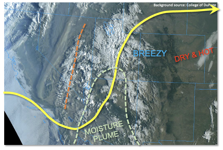
The visible satellite image, below, shows that a vigorous shortwave disturbance is located over CA/NV this morning. Just downstream, deep southerly flow is pumping an impressive moisture surge northward towards the Four Corners region. Precipitable Water (PW) in the southern portion of this plume is well above 1 inch, which is much above normal for mid-September. The main issue in terms of generating rainfall for us here in Colorado is the extremely dry atmosphere overhead. Morning PW was only 0.30 and 0.43 inches in Denver and Grand Junction, respectively. Thus, it will take the majority of the afternoon hours to saturate the atmosphere enough over western Colorado to produce some isolated showers and weaker storms. The timing of this also implies that solar heating will not be able to contribute to generate instability, with maximum CAPE of only a few hundred J/kg expected late today. However, once the atmosphere does become saturated, with a sustained period of lift overhead, scattered showers and an isolated storm are expected to continue over the higher terrain of the Western Slope into the overnight hours. But with limited instability, only modest moisture and fast steering flow, flooding is NOT expected today.
Elsewhere, strong downsloping flow will push temperatures up to 12F above normal east of the Continental Divide today. With this deep boundary layer, gusty winds are expected during the afternoon hours.
Today’s Flood Threat Map
For more information on today’s flood threat, see the map below. If there is a threat, hover over the threat areas for more details, and click on burn areas to learn more about them. For Zone-Specific forecasts, scroll below the threat map.
Zone-Specific Forecasts:
Front Range, Northern Mountains, Northwest Slope, Southwest Slope, Grand Valley, Central Mountains, San Juan Mountains, San Luis Valley and Southeast Mountains:
Increasing clouds, warm and breezy with isolated to widely scattered showers and weaker storms developing late afternoon and persisting into the overnight hours. Max 1-hour rainfall up to 0.5 inches possible, with total precipitation up to 0.7 inches over the higher terrain of the San Juan Mountains and Central Mountains by tomorrow morning. Flooding is NOT expected today. Very gusty winds will be possible with the strongest storms this afternoon and evening.
Primetime: 4PM through 6AM
Raton Ridge, Southeast Plains, Palmer Ridge, Urban Corridor, Northeast Plains:
Mostly sunny, breezy and hot today with temperatures up to 12F above normal (especially over the Northeast Plains). An isolated shower cannot be ruled out over the higher foothills overnight. However, little in any precipitation is expected. Flooding is NOT expected today.