Issue Date: 8/12/2015
Issue Time: 10:35AM
— LOW flood threat for the Palmer Divide, Front Range, Northwest Slope and parts of Central Mountains, Northern Mountains
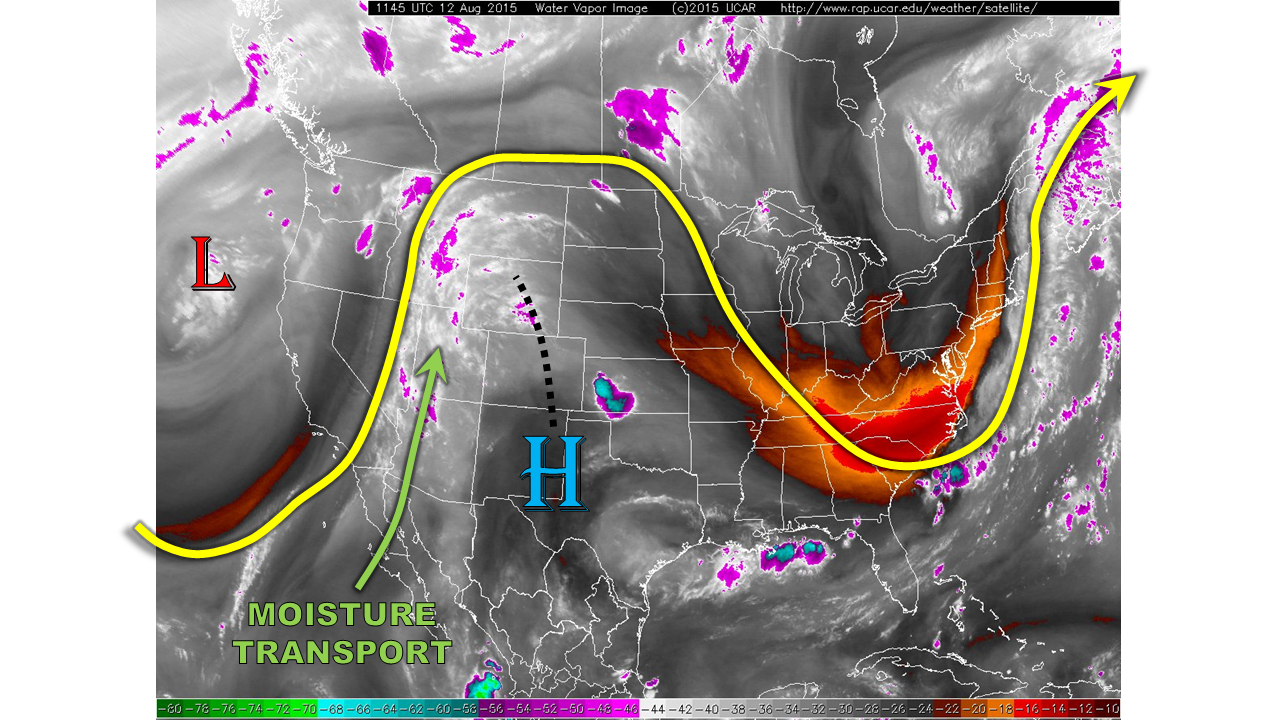
This morning, Colorado is positioned directly under the axis of a stout upper-level ridge, as seen in the water vapor image below. The return flow of very moist monsoonal moisture has been temporarily directed to the west of our state, into Arizona, Utah and Idaho. Typically, this overall setup would imply that we would be lucky to see a drop of rain. However, with the extremely high amount of residual moisture in place, we expect isolated to scattered thunderstorm activity today. Although we do expect a noticeable downtick in coverage, compared to the last few days. Overnight, mid-level temperatures warmed by 3-5 degrees Celsius across the state. Thus, stability this afternoon is expected to be much weaker than yesterday, especially away from higher terrain. However, precipitable water values in the 1.0 – 1.4 inch range (about as high as they get for CO) implies that any storm that does manage to form will be capable of short-term torrential rainfall.
For today, we expect mostly clear skies to quickly give way to scattered thunderstorms over the higher terrain of the Central Mountains, Northern Mountains, as well as the Northwest Slope where return will allow for a continual feed of high moisture content. Isolated storms will have the capability to produce flash flooding, hence a Low flood threat for this region. These storms should diminish rapidly by sunset. Elsewhere a Low flood threat is also in place over the Palmer Ridge where activity moving east and south off the higher terrain could tap into higher moisture and produce isolated flash flooding as well. This activity could last into the late evening hours.
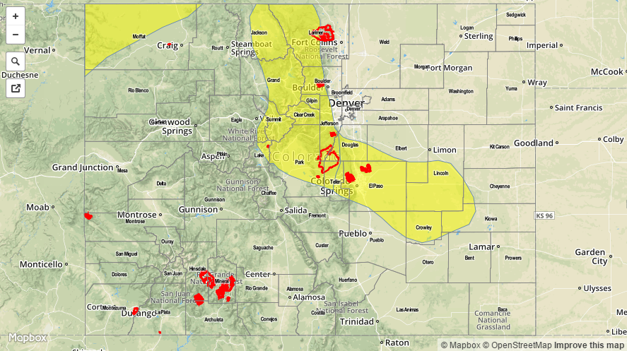
Today’s Flood Threat Map
For more information on today’s flood threat, see the map below (hover over threat areas for more details). For Zone-Specific forecasts, jump below the map.

Zone Specific Forecasts
Central Mountains, Northern Mountains, Northwest Slope, Grand Valley:
Sunny early, then partly to mostly cloudy with isolated to scattered thunderstorms developing by early afternoon. Max 1-hr rain rates up to 1.25 inch will be possible, causing isolated flash flooding and street flooding. Small hail, up to 0.5 inches and gusty winds up to 45 mph may accompany the strongest storms. Storm coverage will likely be highest from mid-afternoon through around sunset.
Primetime: 1pm to 8PM
Front Range, Urban Corridor, Northeast Plains, Southeast Plains, Palmer Ridge, Raton Ridge, Southeast Mountains:
Partly cloudy early, then isolated to scattered showers and thunderstorms forming over the highest terrain by early afternoon. Some storms will be able to move off the mountains and into the plains, especially over the Palmer Ridge. There, max 1-hr rain rates up to 1.8 inches could cause isolated flash flooding and street flooding. A Low flood threat is in place. Activity could persist into the late evening hours as storms find their way into higher moisture and some residual instability.
Primetime: 2PM through 11PM
Southwest Slope, San Juans, San Luis Valley:
Sunny early, then partly cloudy with isolated to widely scattered showers and thunderstorms possible, especially over the higher terrain. Subsidence and unfavorable dynamics will limit 1-hr rain rates to about 0.5 inches. Thus, flooding is not anticipated. Small hail, up to pea-size and gusty winds up to 45 mph could accompany the strongest storm. Activity will subside by sunset.