Issue Date: Tuesday, September 14th, 2021
Issue Time: 9:50AM MDT
— A LOW flood threat has been issued for the Northeast Plains, Palmer Ridge, Southeast Plains and Raton Ridge
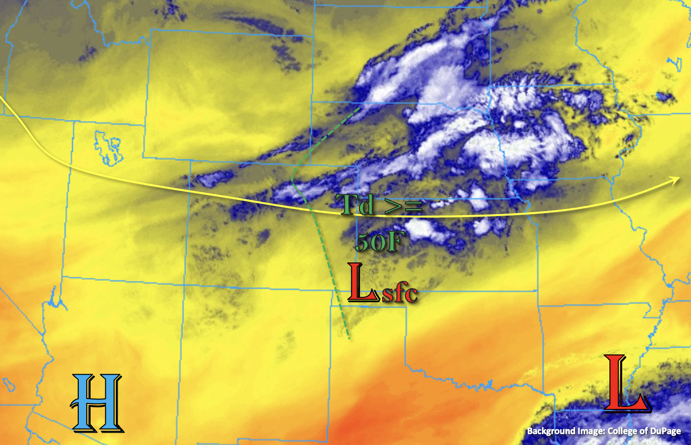
A cold front passed through the state last night, which lead to much cooler morning temperatures across the northern tier of the state this morning. There is still a little bit of upper-level lift helping to generate some weak showers just east of Denver and over Yuma County. Today, post-frontal upslope flow is expected to generate a batch of afternoon storms over the eastern mountains and Palmer Ridge, which should track east and southeast into the adjacent plains by early afternoon. PW, behind the front, has increased to 0.77 inches in Denver with an increasing gradient eastward, over the plains. The higher surface moisture, marked below, should be reinforced by easterly surface winds on the north side of the surface Low. This should allow storms to grow in coverage and intensity as they track into the eastern plains. With decent shear in place from northwesterly flow aloft, a couple severe thunderstorms will be possible with the main threats being large hail and strong outflow winds. These would most likely occur along and south of I-70 and east of I-25 over the Southeast Plains and eastern Palmer Ridge; however, an isolated storm could break the cap over the far Northeast Plains as well with enhanced lift over the area. Steering flows should be just quick enough that widespread flooding issues should be avoided, but local, heavy rainfall may still be possible in the stronger storm cores that can develop. For this reason, a LOW flood threat has been issued.
Over western Colorado, flow aloft will turn more northwesterly throughout the day, which will begin to pull in a dry air mass from western Wyoming and northern Utah. Between this, the already dry boundary layer and an increase in stability behind the passing trough, rainfall is not anticipated for the lower elevations. A couple isolated, high-based storms will still be possible over the Central and San Juan Mountains near the Continental Divide, but flooding is not expected over these regions.
Today’s Flood Threat Map
For more information on today’s flood threat, see the map below. If there is a threat, hover over the threat areas for more details, and click on burn areas to learn more about them. For Zone-Specific forecasts, scroll below the threat map.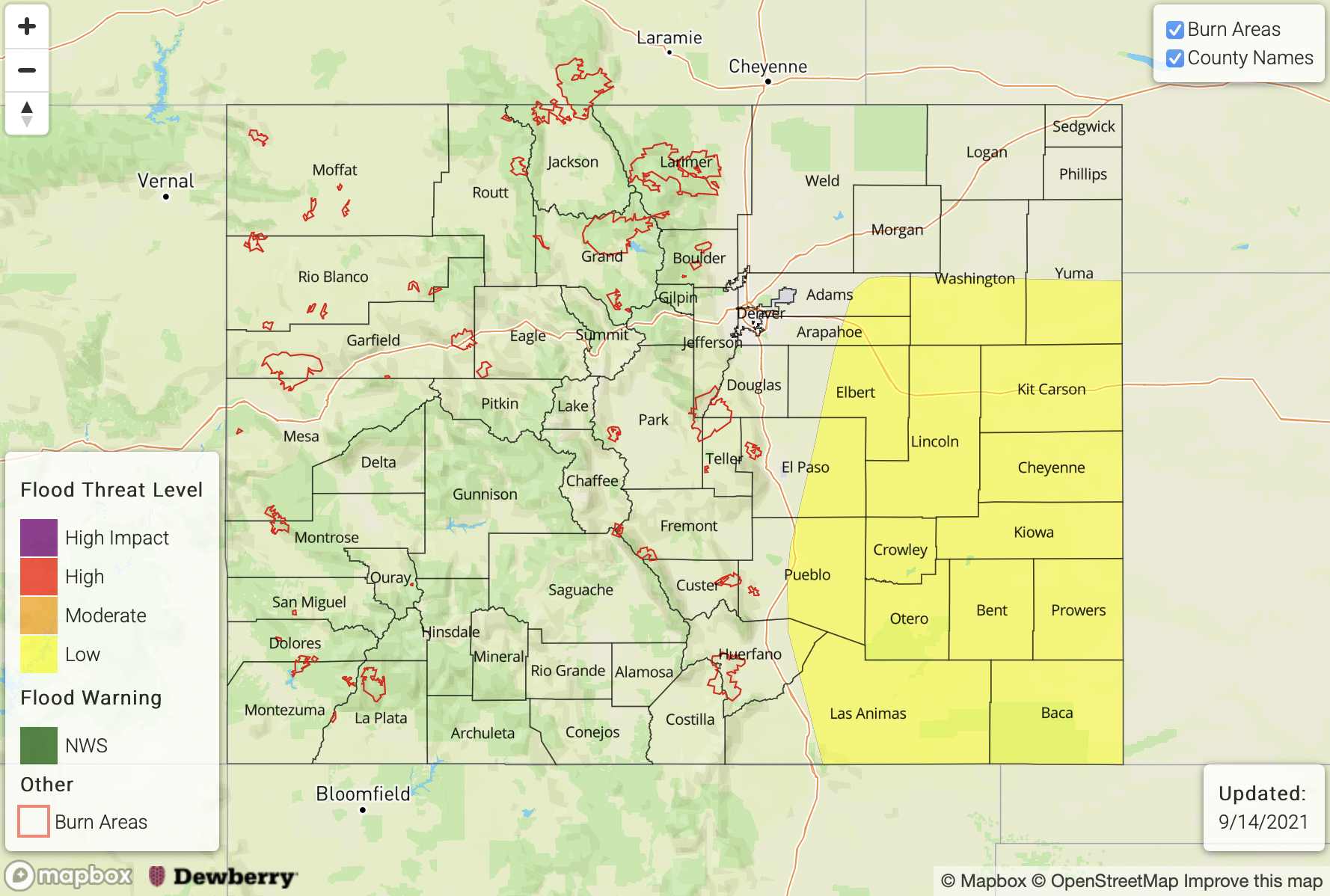
Zone-Specific Forecasts:
Front Range, San Juan Mountains, Southeast Mountains & Central Mountains:
Scattered weak storms should develop over the mountains this afternoon favoring the southern Front Range and Southeast Mountains for development. With a dry boundary layer, storms should be rather weak in nature and may produce some strong outflow winds. Max 1-hour rain rates up to 0.25 inches will be possible, but most storms are expected to produce under 0.15 inches of rainfall. Flooding is NOT expected.
Primetime: 1PM to 9PM
Northeast Plains, Southeast Plains, Urban Corridor, Raton Ridge & Palmer Ridge:
Better moisture, lift and instability are forecast over these regions, although it looks like most of the Urban Corridor will be capped as well as areas north of the front (Northeast Plains). A couple severe thunderstorms will be possible this afternoon with the main threats being damaging outflow winds and large hail. Local, heavy rainfall will be possible in the storm cores, so a LOW flood threat has been issued. Max 1-hour rain rates up to 1.10 inches (west) and 1.75 inches (east) are possible. This could cause road flooding, local creek/stream flooding as well as field ponding.
Primetime: 2PM to 11:30PM
Northwest Slope, Northern Mountains, Grand Valley, San Luis Valley & Southwest Slope:
Flooding is NOT expected today, nor is any rainfall. Cooler temperatures are forecast, especially north where valley locations should stay in the upper 70Fs to low 80Fs. Over the Grand Valley and south, lower elevations should be in the mid to upper 80Fs.