Issue Date: 8/11/2015
Issue Time: 10:05 AM
A HIGH IMPACT FLOOD THREAT HAS BEEN ISSUED FOR PORTIONS OF THE URBAN CORRIDOR AND FRONT RANGE.
A MODERATE FLOOD THREAT IS ISSUED FOR PORTIONS OF THE URBAN CORRIDOR, PALMER RIDGE, NORTHEAST PLAINS, SOUTHEAST PLAINS, RATON RIDGE, SAN JUAN MOUNTAINS, SOUTHWEST SLOPE, AND GRAND VALLEY.
A LOW FLOOD THREAT IS ISSUED FOR PORTIONS OF THE NORTHEAST PLAINS, SOUTHEAST PLAINS, PALMER RIDGE, RATON RIDGE, URBAN CORRIDOR, FRONT RANGE, SOUTHEAST MOUNTAINS, CENTRAL MOUNTAINS, NORTHERN MOUNTAINS, NORTHWEST SLOPE, SAN JUAN MOUNTAINS, SOUTHWEST SLOPE, AND GRAND VALLEY.
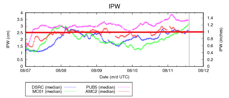
Today will be another active day as the depth of moisture has really become impressive across the state. The increase in moisture is fairly easy to pick out on the IPW graph below. Beginning around 6 PM Sunday, the monsoonal moisture plume began to move back over Colorado, and the increase has continued through this morning with all four normal reporting stations (Boulder, Grand Junction, Pueblo, and Shriever AFB) near, or above, 1.0 inches. The 1.0 inch IPW mark is a rough threshold for heavy rain concerns in Colorado; there will be plenty of moisture available to storms.
Scattered thunderstorms are expected across much of the High Country regions (including their lower elevations), Urban Corridor/Front Range south of I-70, Palmer Ridge, Raton Ridge, and Southeast Plains. More isolated storm coverage is expected over the Northeast Plains, and Urban Corridor/Front Range north of I-70. With the amount of moisture available, most thunderstorms will invoke efficient precipitation processes, thus the large spatial extent of flood threat area today. For more information on maximum rain rates and timing, be sure and check the zone-specific forecast discussions below.
The reasoning behind issuing the first High Impact Flood Threat really hinges on four things: 1) High maximum rain rates of 2-3 inches/hour due to deep moisture, 2) Saturated soils from the previous 36-48 hours of rainfall, 3) Relatively slow storm motion, and 4) Population Density. A couple of water rescues were performed across the area as cars became stranded in high water over roads, debris/fast-flowing water from the Waldo Canyon Burn Scar inundated roads, damaged business in Manitou Springs, and damaged cars in western Colorado Springs. With scattered storms capable of producing equal, or greater, rain rates, and on top of saturated soil, runoff will occur quicker today than yesterday. Be prepared if a strong thunderstorm moves over areas that received heavy rainfall yesterday, and remember: Turn Around, Don’t Drown.
Today’s Flood Threat Map
For more information on today’s flood threat, see the map below (hover over threat areas for more details). For Zone-Specific forecasts, jump below the map.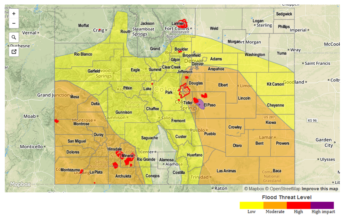
Zone-Specific Forecasts
Urban Corridor/Front Range north of I-70, and Northeast Plains:
Isolated storms are expected, with chances decreasing from west to east. Maximum rain rates will be 1.2-1.8 inches/hour over the Northeast Plains, and 0.9-1.3 inches/hour over the Urban Corridor/Front Range north of I-70.
Timing: Noon/1 PM – Midnight
Urban Corridor/Front Range along and south of I-70, Raton Ridge, Palmer Ridge, and Southeast Plains:
Scattered thunderstorms capable of heavy rainfall are expected today and tonight, with maximum rain rates breaking down like this:
Urban Corridor south of I-70, and Palmer Ridge: 2-3 inches/hour
Front Range south of I-70: 1.2-2.2 inches/hour
Raton Ridge and Southeast Plains: 1.6-2.4 inches/hour
Not every location will receive rainfall, but those that do will likely experience at least brief heavy rainfall. Slow-storm motions are a concern, especially for moderate and high impact flood threat areas.
Timing: Noon – Midnight, with one or two showers/thunderstorms lingering into the early morning hours.
Northern Mountains, Central Mountains, Southeast Mountains, San Juan Mountains, Grand Valley, and Southwest Slope:
Scattered showers and thunderstorms are ongoing, and are expected to continue throughout the day and into the nighttime hours. There will be a few scattered showers/weak thunderstorms that continue into the early morning, especially across southwestern Colorado. Maximum rain rates break down like this:
Northern Mountains: 0.8-1.1 inches/hour
Central Mountains: 0.9-1.2 inches/hour
Southeast Mountains: 1.4-1.8 inches/hour
San Juan Mountains, Grand Valley, and Southwest Slope: 1.2-1.8 inches/hour
Timing: Currently – Midnight, with a few showers/storms lingering into the early morning hours tomorrow
Northwest Slope and San Luis Valley:
Isolated showers and thunderstorms expected, otherwise will be partly sunny. Maximum rain rates will be 0.8-1.2 inches/hour for the strongest storms, mainly over/near the higher terrain. Moisture is less across the Northwest Slope than any other region in Colorado, and thus escapes much of the flood threat.
Timing: 11 AM – 10 PM, with one or two isolated showers continuing into the early morning hours.