Issue Date: Saturday, September 4th, 2021
Issue Time: 10:05 AM MDT
Summary:
The end of the work week began with early morning showers and storms lingering around the Northeast Plains and Palmer Ridge before lifting and dissipating with the general eastward movement. However, it was not long before more widespread thunderstorm development across the state, including the necessary moisture and lift needed for some severe weather. Scattered thunderstorms began firing up in the late morning and early afternoon in the Northern, Central, and Front Range Mountains, moving eastward onto the Urban Corridor and becoming more organized. As the afternoon progressed, storms formed in the Western Slopes and Grand Valley as well. There was less available moisture for heavy rainfall west of the divide, but a different story to the east.
An early afternoon severe thunderstorm made its way across the South Denver Metro Area, causing 0.50-1.00 hail reports across a large swatch of the southern suburbs: Lakewood, Littleton, Highlands Ranch, and near Chatfield Reservoir. High winds were also reported – up to 64 mph gusts at KAPA in Centennial. Hail wasn’t just large, there was enough to blanket the ground like snow Littleton!
This is what Littleton CO hail storm looked like at my place yesterday.#cowx @9NEWSWeather @KDVR #cohail #hail #SaturdayMorning pic.twitter.com/fAhvPKRitw
— Eric Graham (@egraham70) September 4, 2021
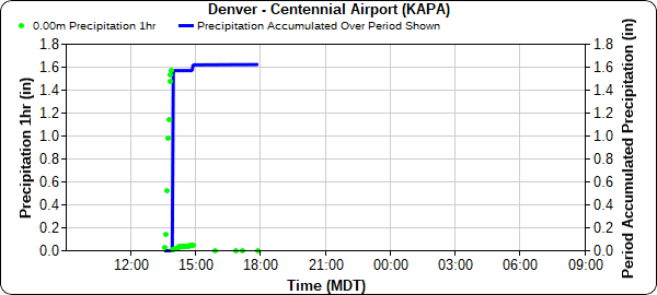
The Centennial Airport also received 1.62 inches of rain yesterday with most of that, 1.57 inches, falling in a single hour. Precipitation Frequency Estimates from NOAA Atlas 14 in this area put 1.57 inches in an hour to be between a 10-year and 25-year event or 4-10% chance of occurrence in any given year. Other high precipitation totals around the South Denver Metro Area include 1.64 in Highlands Ranch, 1.35 in Littleton, 1.29 in Parker, and 0.97 in Aurora.
The heavy rain and hail caused street flooding across the area, prompting response from South Metro Fire Rescues for vehicles stranded in high water.
SMFR is responding to severe thunderstorm related incidents including several vehicles stranded in high water. No injuries have occurred and no rescues have been needed. Please do not drive into water of unknown depth. #COwx pic.twitter.com/NikFFS5lnK
— South Metro Fire Rescue (@SouthMetroPIO) September 3, 2021
The storms quickly moved off the Urban Corridor with eastward movement of the trough axis, forming a line of storms from the northeast corner of the state all the way to Colorado Springs in the afternoon. Fast-moving storms produced heavy rainfall across the Northeast Plains and Palmer Ridge including: 1.95 inches in Burlington, 1.40 inches in Vernon, 1.30 inches in Woodrow, 0.93 inches in Akron, and 0.71 inches south of Greeley.
A second round of thunderstorms on the Southeast Plains prompted three severe thunderstorm warnings for counties on the Colorado-Kansas border overnight. Up to 57 mph wind gusts were reported in Aroya, CO. Storms continued well into the early morning hours before moving eastward out of the state, but not before dropping impressive, and much needed, heavy rain. Rainfall totals in Southeast Colorado include: 1.95 inches in Holly, 1.94 in Timpas, 1.40 in Haswell, 1.33 in Rocky Ford, and 1.00 inch in Lamar. The 1.95 inches in Holly was likely also in just under an hour, with PF estimates placing this event between a 2-year and 5-year rainfall event (20-50% chance in any given year).
Further west, a flash flood warning was issued for the Grizzly Creek burn scar in Glenwood Canyon after 4:00 pm yesterday, which prompted an I-70 safety closure. Up to 0.60 inches of rain fell yesterday in Glenwood Springs and the surrounding area of Glenwood Canyon. Fortunately, no flooding or debris flows were reported and I-70 reopened last night.
For rainfall estimates in your area, check out the State Precipitation Map below.
Click Here For Map Overview

