Issue Date: Friday, September 3rd, 2021
Issue Time: 10:25AM MDT
— A LOW flood threat has been issued for the Urban Corridor, Northeast Plains, Palmer Ridge & Southeast Plains
— This is an overnight flood threat
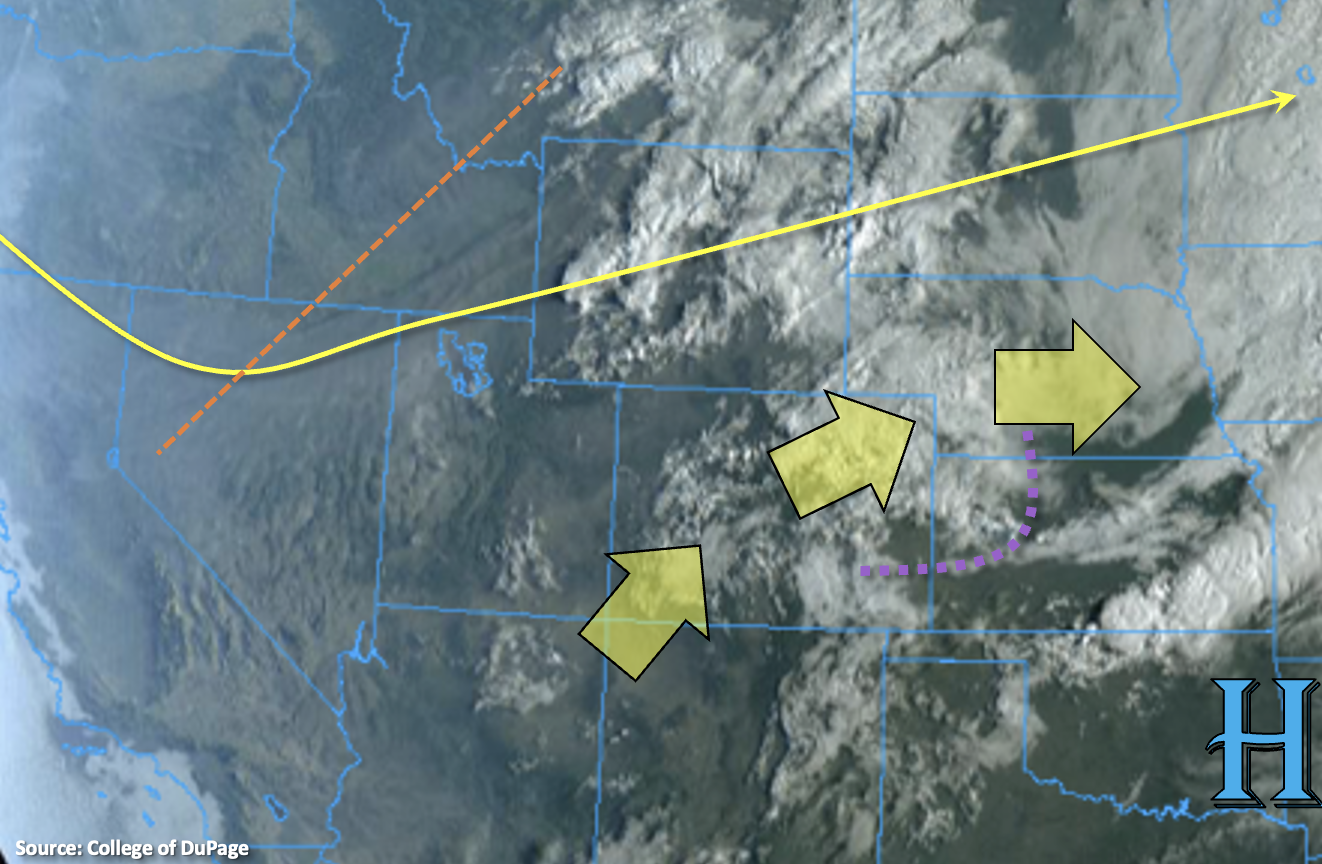
The upper-level trough will continue to approach from the west today and turn this morning’s southwesterly flow aloft more westerly by this afternoon. This should continue to scour out any remaining surface moisture over the western portion of the state and limit the scattered, high-based storm coverage to the high terrains and elevated plateaus. As the trough approaches, the upper-level winds are also expected to pick up just north of the border. This should keep storms moving relatively quickly that develop over the Northern/Central Mountains and Front Range. Together, these two forecast elements should effectively limit the flood threat over the area.
For the most part, as the mountain storms are steered into the adjacent plains with the westerly flow, they will likely be moving too quickly to cause more than nuisance flooding issues. However, a couple training storms may be possible over the Palmer Ridge where some better surface moisture can hang on with increased dynamics, so a LOW flood threat has been issued for the area. As the storms continue to move east and southeast and into higher moisture over the plains, the convection is expected to “line out” and become more widespread. With decent shear over the area, the storm complex is anticipated to intensify, and storms may be capable of producing severe weather which includes large hail, damaging winds and dangerous lightning. Due to the anticipated increased of rain rates over the area with the higher moisture, a LOW flood threat has been issued.
Finally, another moisture axis looks like it will set up over the Southeast Plains today and lasts through the overnight hours. With possible boosted lift from the low-level jet tonight across the southern border and enhanced convergence along this boundary, training storms may develop over the Southeast Plains tonight. With dew points around 60F or slightly above, the storms would have the potential to cause local heavy rainfall and flooding issues, so the LOW flood threat continues overnight.
Today’s Flood Threat Map
For more information on today’s flood threat, see the map below. If there is a threat, hover over the threat areas for more details, and click on burn areas to learn more about them. For Zone-Specific forecasts, scroll below the threat map.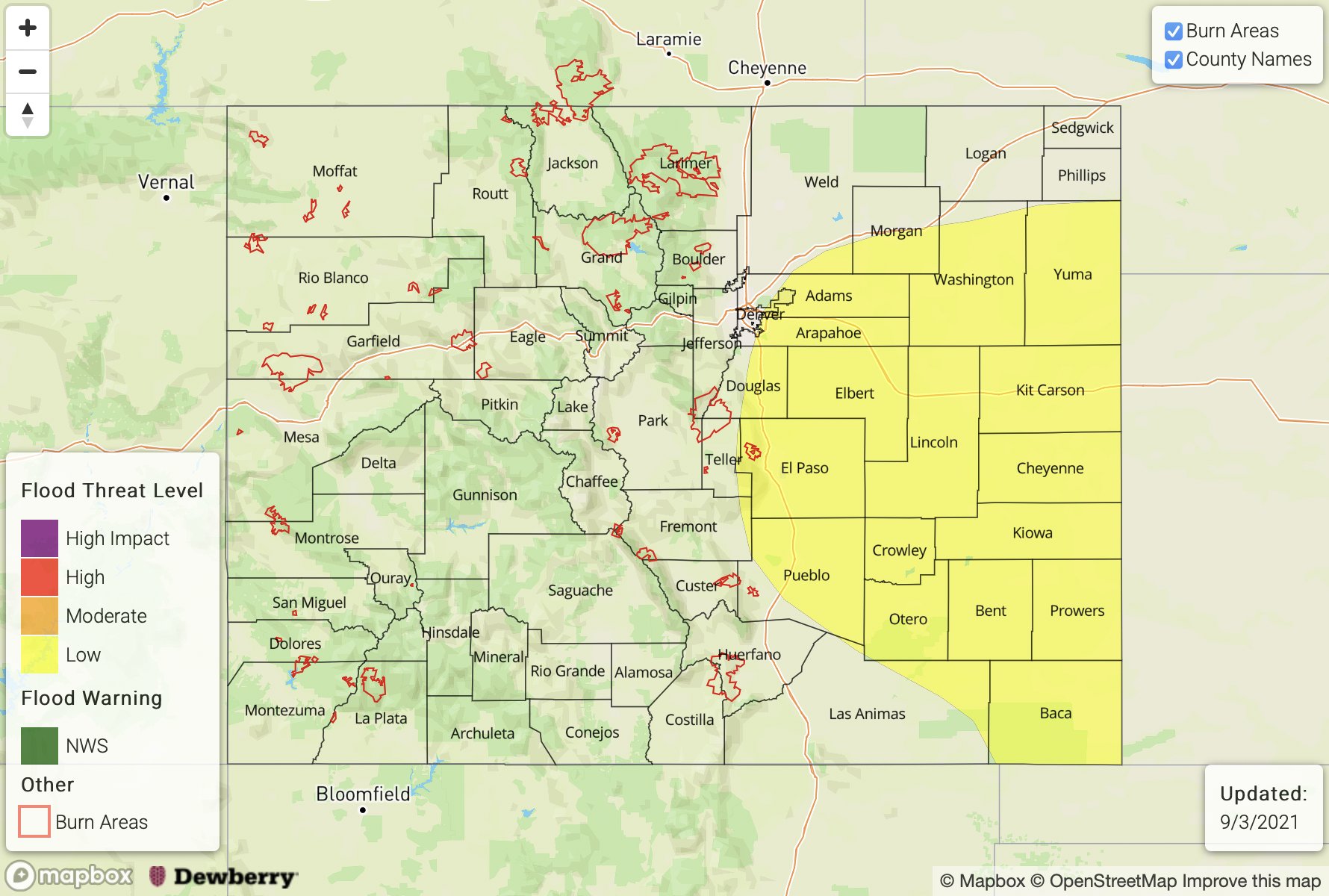
Zone-Specific Forecasts:
Southeast Plains, Northeast Plains, Southeast Mountains, Front Range, Raton Ridge, Urban Corridor & Palmer Ridge:
Faster moving storms should help limit the flood threat today back to the west today. However, training storms may be possible in a pool of moisture over the Palmer Ridge with enhanced convergence, so a LOW flood threat has been issued. Max 1-hour rain rates up to 1.25 inches with local storm totals up to 2 inches may be possible. As storms move east, they will likely form a line and be capable of producing large hail and damaging wind gusts along with lightning and heavy rainfall. An isolated tornado may be possible (south). With max 1-hour rain rates forecast up to 2.25 inches, a LOW flood threat has been issued. It’s possible for another round of overnight storms across the Southeast Plains, and training storms may cause 3-hour rain rates up to 3.50 inches, so the LOW flood threat continues into the overnight hours for this area. Flood threats today include road, local stream and arroyo flooding as well as heavy field ponding.
Primetime: 3PM to 6AM
San Juan Mountains, Southwest Slope, Central Mountains, San Luis Valley, Grand Valley, Northwest Slope & Northern Mountains:
The scattered storms that develop over western Colorado mountains and elevated plateaus are expected to favor the northern/central regions with more isolated pops further south. Max 1-hour rain rates up to 0.25 inches are forecast with isolated storm totals up to 0.50 inches possible. Flooding is NOT forecast today, and activity should come to an end by the evening hours.
Primetime: 1PM to 9PM