Issue Date: 8/10/2015
Issue Time: 10:05 AM
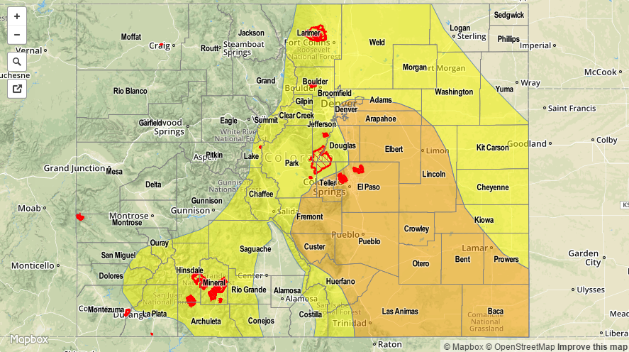
A MODERATE FLOOD THREAT IS ISSUED FOR PORTIONS OF THE URBAN CORRIDOR, FRONT RANGE, PALMER RIDGE, SOUTHEAST PLAINS, SOUTHEAST MOUNTAINS, RATON RIDGE, AND NORTHEAST PLAINS.
A LOW FLOOD THREAT IS ISSUED FOR PORTIONS OF THE NORTHEAST PLAINS, SOUTHEAST PLAINS, PALMER RIDGE, URBAN CORRIDOR, FRONT RANGE, NORTHERN MOUNTAINS, CENTRAL MOUNTAINS, SOUTHEAST MOUNTAINS, RATON RIDGE, SAN JUAN MOUNTAINS, AND SOUTHWEST SLOPE.
Today’s forecast discussion could drag on for hours with the set-up in place, but I will attempt to keep it as clear and concise as possible. The water vapor imagery sets up the background environment quite well: upper-level high over Texas, upper-level low just off the west coast, mid-/upper-level disturbance extending across AZ/NV/CA/OR (black line), and monsoonal moisture streaming into NM/AZ/CO (green arrow).
The depth of the monsoonal moisture will increase, especially across southern and central Colorado, throughout today and tonight as the upper-level high builds westward and pushes the moisture stream directly overhead. In addition to this moisture increase, areas along and east of the Front Range and Southeast Mountains will see surface moisture reinforced as the winds turn southeasterly through the afternoon and evening hours. The depth of moisture will allow scattered thunderstorms to produce locally moderate-to-heavy rainfall.
An additional concern arises this afternoon/evening, as the southeasterly surface flow will likely develop a Denver Convergence Zone. If the convergence zone develops, a couple of well-organized, heavy rainfall producing storms will be possible across portions of the Urban Corridor, Palmer Ridge, and adjacent plains this afternoon/evening. In general, thunderstorms will develop along the Front Range and Southeast Mountains early this afternoon, spreading eastward with time through the evening hours.
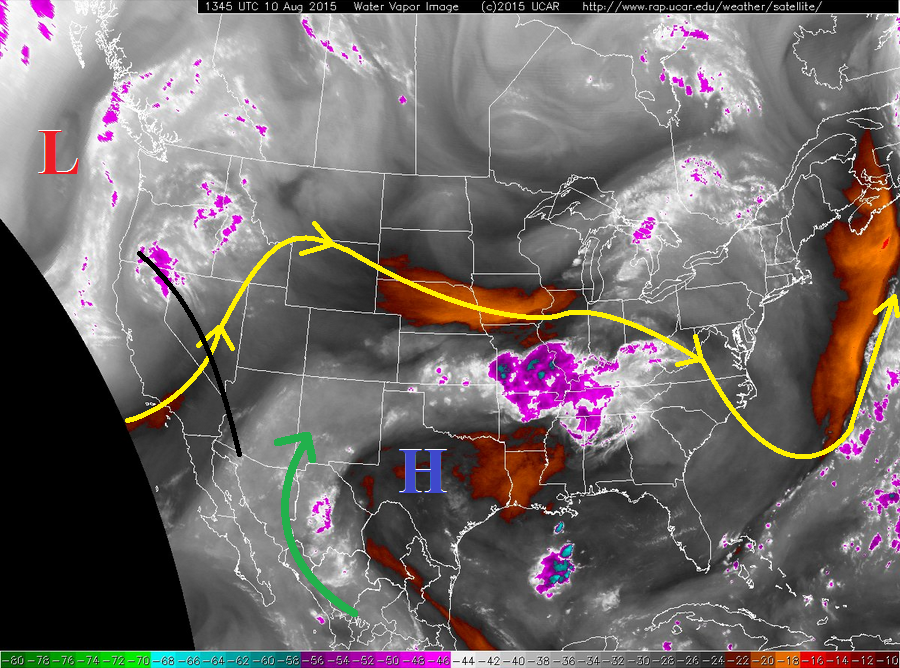
Elsewhere over western Colorado: Scattered thunderstorms are expected over the San Juan Mountains and Central Mountains, with more isolated coverage over the higher terrain of the Northern Mountains, San Luis Valley, and Southwest Slope. The Grand Valley and Northwest Slope regions will remain mainly dry. The Central Mountains and San Juan Mountains will be the likeliest regions to see moderate rainfall, while the other regions will mainly experience light rainfall and gusty winds from any thunderstorm activity. Rain rates are discussed below in the zone-specific discussions.
Overnight, a repeat of overnight last night appears possible for southern portions of the Urban Corridor, Palmer Ridge, Southeast Plains, and to some extent the Northeast Plains. Isolated-to-scattered slow-moving thunderstorms will be possible as easterly/southeasterly flow continues into the early morning hours. Locally heavy rainfall will be a threat if storms can develop. Probability of occurrence for this scenario is roughly 40%.
Today’s Flood Threat Map
For more information on today’s flood threat, see the map below (hover over threat areas for more details). For Zone-Specific forecasts, jump below the map.

Zone-Specific Forecasts
Urban Corridor, Northeast Plains, Raton Ridge, Palmer Ridge, and Southeast Plains:
Scattered thunderstorms expected through the afternoon and evening hours, with a few isolated thunderstorms lingering into the overnight hours, mainly along and south of I-70. See discussion above for more details. Maximum rain rates will be 1.2-2.0 inches/hour near the mountains, and 2.0-3.0 inches/hour further east.
Timing: 11 AM – 6 AM
Front Range, Northern Mountains, Central Mountains, Southeast Mountains, San Juan Mountains, San Luis Valley, and Southwest Slope:
Isolated-to-scattered thunderstorms expected to develop around 11 AM, and continue through the afternoon and evening hours. Overnight, a few isolated showers/thunderstorms will continue over the higher terrain of the San Juan Mountains, Southwest Slope, and Southeast Mountains. Maximum rain rates are as follows:
Front Range and Southeast Mountains: 1.2-2.0 inches/hour
Northern Mountains, Central Mountains, San Juan Mountains, and Southwest Slope: 0.8-1.2 inches/hour
San Luis Valley: 0.4-0.8 inches/hour
Timing: 11 AM – Midnight
Northwest Slope and Grand Valley:
Mostly sunny early, becoming partly sunny this afternoon and evening. An isolated shower/thunderstorm or two cannot be ruled out over the higher terrain, but the day for most areas will be marked by dry conditions.