Issue Date: Friday, September 3rd, 2021
Issue Time: 10:25 AM MDT
Summary:
Residual moisture left behind from widespread rainfall on Wednesday allowed for isolated showers in the Western Slopes, Grand Valley, North and Central Mountains to kick off Thursday morning. Late morning to early afternoon rainfall totals were highest in the Southwest Slope, with 24-hour accumulations around the Utah-Colorado border between 0.63-0.76 inches according to CoCoRaHS observers.
Daytime heating allowed for more widespread shower and thunderstorm development across Western and Central Colorado, and then the Front Range Mountains before spilling onto the Urban Corridor and Palmer Ridge. Most of the Urban Corridor received some rainfall yesterday, though rainfall rates and total precipitation varied, Trace – 0.20 inches were reported between Fort Collins and Castle Rock.
A Flood Advisory was issued shortly after 5:00 pm yesterday in the Northern Mountains, including a portion of the East Troublesome burn area and CO-125, after Doppler radar indicated heavy rain due to thunderstorms. A minor debris flow did occur on CO-125 yesterday in Grand County due to recent rain. CDOT crews were able to quickly clear the highway without closure and no injuries were reported. The Grand County Sherriff shared the following video on twitter taken from a Deputy traversing the debris flow. Based on the trees on the ridgeline, it is likely the debris flow occurred on the East Troublesome burn scar.
🚨Video from a Deputy driving on #CO125 on 9/2 as there were a few of mudslides along the hwy due to recent rain. The Hwy remained open & did not close, @ColoradoDOT crews cleared the mud/debris. We are thankful that all remained safe!
https://t.co/4JyFGZ9EDQ#COwx #coflood pic.twitter.com/LRhQasehZb— Grand County Sheriff (@GrandCoSheriff) September 3, 2021
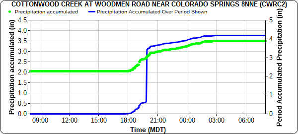
Areas along the Palmer Ridge and Eastern Plains saw heavy rain yesterday evening into the early morning hours as storms developed along a stationary frontal boundary draped across the region. Training thunderstorms produced between 0.80-1.43 inches of rain across Colorado Springs. The following time series plot of rainfall at Cottonwood Creek near Colorado Springs reported 1.43 inches of rain after 6:00 pm yesterday to 3:00 am this morning.
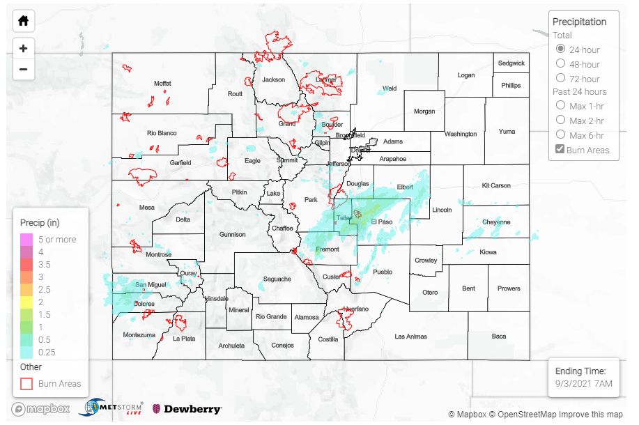
Eastward movement of the overnight showers and thunderstorms resulted in the Northeast Plains and Northern portion of the Southeast Plains waking up to showers this morning. For rainfall estimates in your area, check out the State Precipitation Map below.
Click Here For Map Overview
Note: The 24-hour, 48-hour and 72-hour total precipitation do not contain bias corrections today due to errors in the CoCoRaHS data. This means there may be underestimations in QPE over the southwest and southeast corners of the state.

