Issue Date: Thursday, September 2nd, 2021
Issue Time: 9:50AM MDT
— A LOW flood threat has been issued for the southern Front Range, southern Urban Corridor, Palmer Ridge, northern Southeast Plains and southern Northeast Plains
— Possible PM update may be issued
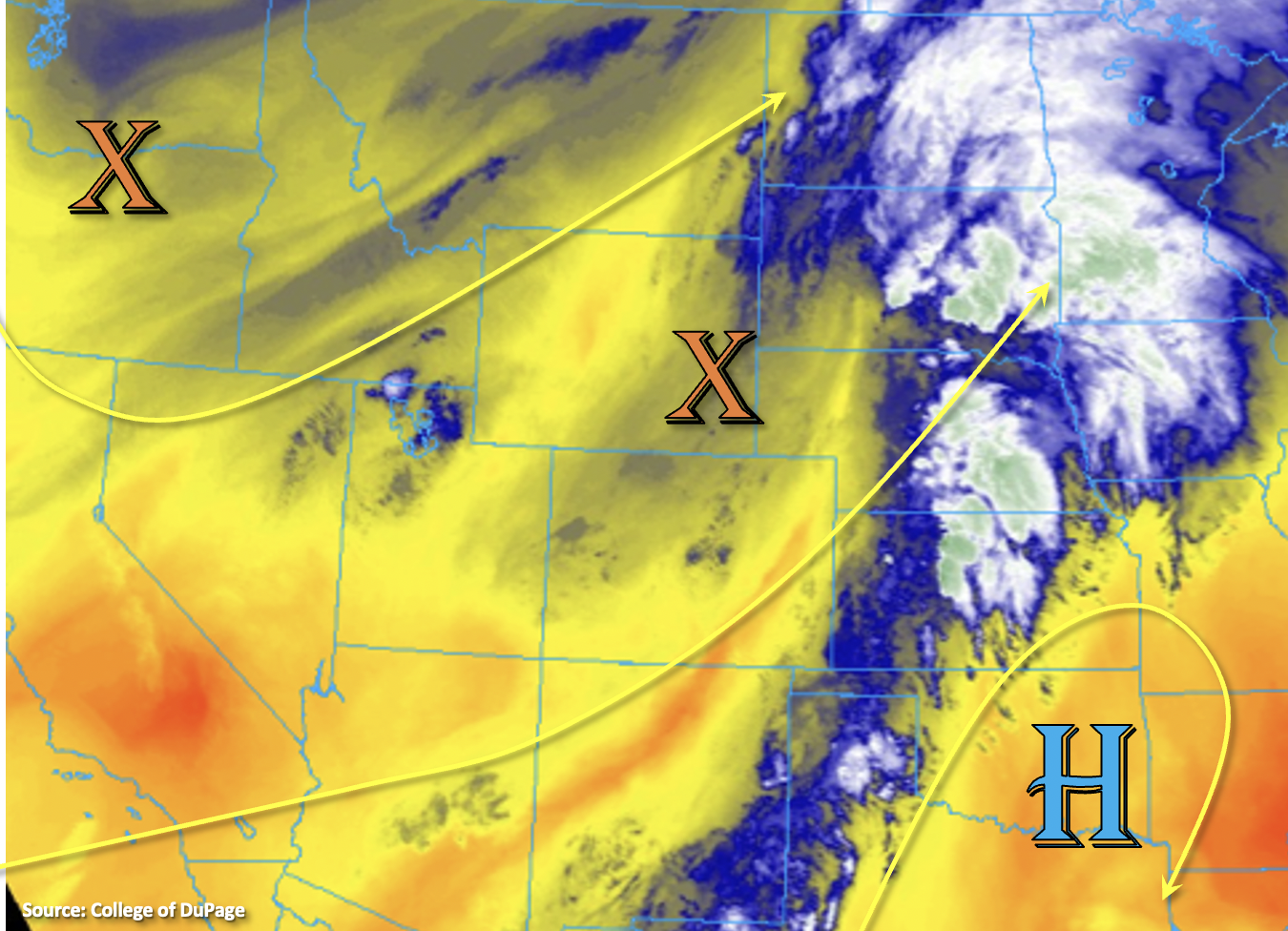
Southwesterly flow aloft continues across the state this morning with the main axis of precipitation to our east. There are still some ongoing, scattered showers over the western portion of the state and Northern Mountains, which indicates a little mid-level lift in the area in an otherwise subsidence promoting environment. Flow aloft by midday will become more westerly as another trough drops in from the Pacific Northwest (orange “X”). This will begin to pull in a drier air mass across western Colorado, which will start to drop PW values and decrease the chances for rainfall over the next several days. However, there should still be enough residual moisture and mid-level lift for a round of scattered, mountain storms this afternoon and evening favoring areas south of I-70. So, expect the current showers to expand a little bit in coverage and intensity as they meander west throughout the day. A couple evening storms may also be possible over the Grand Valley and Northwest Slope, but with instability dropping off rapidly with the sun setting, storms should dissipate rather quickly. With the smaller storm cores and lower-end rainfall rates today, flooding is not expected over this area.
PW at Denver has risen to just under 1 inch over the last 24-hours, and this moisture is forecast to hang on through tomorrow night. With mid-level energy approaching from the west, scattered storms are forecast to return to the area, and more so than yesterday, they are expected to spill into the southern Urban Corridor. Best coverage of showers and storms will be over the southern Front Range and Palmer Ridge where there will be a bit better convergence and mid-level lift. Slower steering flows and training storms may cause some localized flooding issues with the above-average moisture over the Palmer Ridge, if a couple stronger thunderstorms can develop. There is also the possibility of some overnight storms in this area with an uptick in lift forecast. A nice theta-e gradient may work its way into the eastern plains, and if storms generate along this feature, heavy rainfall should be expected. For these reasons, a LOW flood threat has been issued. Should this threat for overnight storms drop off by this afternoon, a PM update will be issued.
Today’s Flood Threat Map
For more information on today’s flood threat, see the map below. If there is a threat, hover over the threat areas for more details, and click on burn areas to learn more about them. For Zone-Specific forecasts, scroll below the threat map.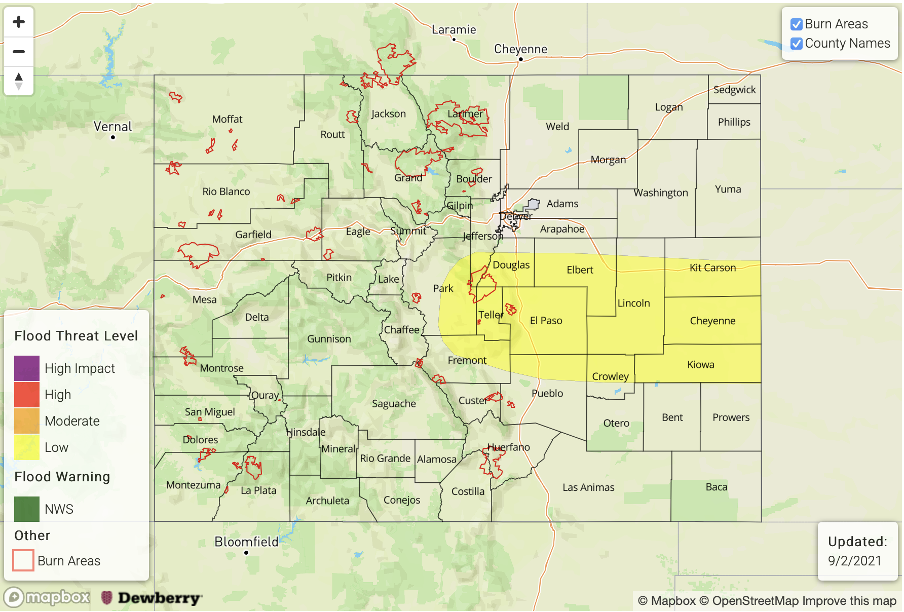
Zone-Specific Forecasts:
Southeast Plains, Northeast Plains, Southeast Mountains, Front Range, Urban Corridor, Palmer Ridge & Raton Ridge:
Afternoon and evening storms are expected over the central, eastern Colorado as the mid-level lift works its way over from the west. Subsidence elsewhere should keep storm chances limited over the northern/southern mountains. In addition to training and slow-moving storms this afternoon/evening, some storms will be possible over the Palmer Ridge and eastern plains overnight. Rainfall that develops along a theta-e axis (front) overnight may also be capable of producing heavy rainfall. Max 1-hour rain rates up to 1.75 inches and storm totals up to 3 inches will be possible. Therefore, a LOW flood threat has been issued for possible road flooding, bankfull conditions of local streams/creeks, mud flows/debris slides (west) and field ponding under the more robust storm cores. A couple thunderstorms may also be capable of producing small hail, strong outflow winds and dangerous lightning. Note that this is an overnight threat.
Primetime: 12:30PM to 6AM
San Juan Mountains, Northern Mountains, Central Mountains, Southwest Slope, San Luis Valley, Grand Valley & Northwest Slope:
More scattered storms are forecast today over the higher terrains mostly south of I-70. Without much instability being able to build, rainfall rates should be on the lower end and accumulations should be gradual enough, and over a small enough area, to avoid flooding issues. A quick 0.50 inches of rain may be able to fall over a 30-minute period if a couple stronger storms can develop. Isolated morning totals up to 1 inch will be possible over the higher terrains of the Northwest Slope (south), Grand Valley and San Juan Mountains, but flooding is NOT forecast today.
Primetime: Ongoing to 10PM