Issue Date: Wednesday, September 1st, 2021
Issue Time: 10:20AM MDT
— A MODERATE flood threat has been issued for the Southwest Slope, San Juan Mountains, Northwest Slope and Grand Valley
— A LOW flood threat has been issued for the Central Mountains, Northern Mountains, San Luis Valley and Southeast Mountains
Southeastward progression of the trough, to our north, has helped pull the Low, off the coast of California, inland. As the day continues, the Low is forecast to be absorbed into the stronger southwest flow, which will bring enhanced mid and upper-level lift across the state. This will help create two distinct areas of precipitation over the state, one over western Colorado and the Southeast Mountains and the other over the eastern plains along a surface trough. Downsloping flow from the lee trough should help to keep precipitation chances fairly low across the Front Range and northern Urban Corridor.
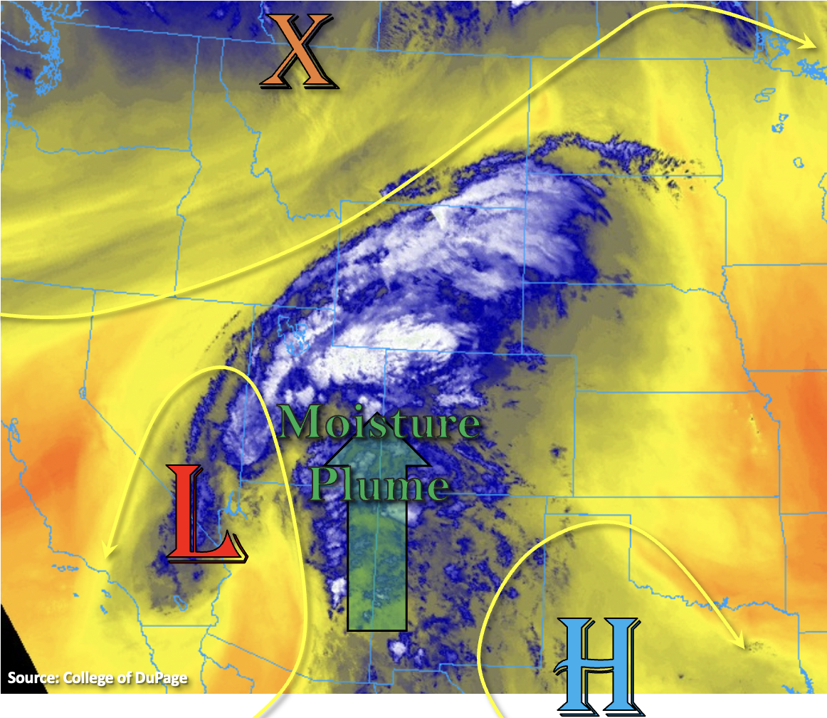
In the meantime, the location of the California Low has created southerly flow aloft, which has advected the plume of subtropical moisture more into western Colorado. PW at Grand Junction has risen to 1.13 inches, which is just a couple hundredths shy of the daily maximum value. The first batch of showers has already arrived to the northwest corner of the state, and throughout the day, showers and storms are expected to increase over all of western Colorado. With better moisture available within the surface layer today, rain rates and accumulations are expected to be higher than yesterday. One limiting factor to the flood threat will be the lack of daytime heating, which should decrease the chance for widespread thunderstorm development. Another limiting factor will be faster southwest steering flows, which should limit the flood threat from any individual storm. However, continuous southwesterly flow and extra lifting dynamics are expected to help initiate multiple rounds of rainfall, training storms and embedded convection. All of which will increase the flood threat, but over a longer duration than the typical 1 to 2 hour threat. A MODERATE flood threat has been issued, which continues into tonight.
Back to the east, PW at Denver was measured at 0.73 inches, which is expected to increase throughout the day as the moisture plume moves east. A drier surface layer was noted in the sounding, which paired with the faster southwest steering flows, should help thunderstorm accumulations from reaching flood threat criteria over the eastern plains. With an increasing moisture gradient towards the southern border, it is possible that storms that develop over the Southeast Mountains, on southwest facing slopes, may produce some heavier rainfall, which could cause some local flooding issues. Thus, the Low flood threat has been extended into this region.
Today’s Flood Threat Map
For more information on today’s flood threat, see the map below. If there is a threat, hover over the threat areas for more details, and click on burn areas to learn more about them. For Zone-Specific forecasts, scroll below the threat map.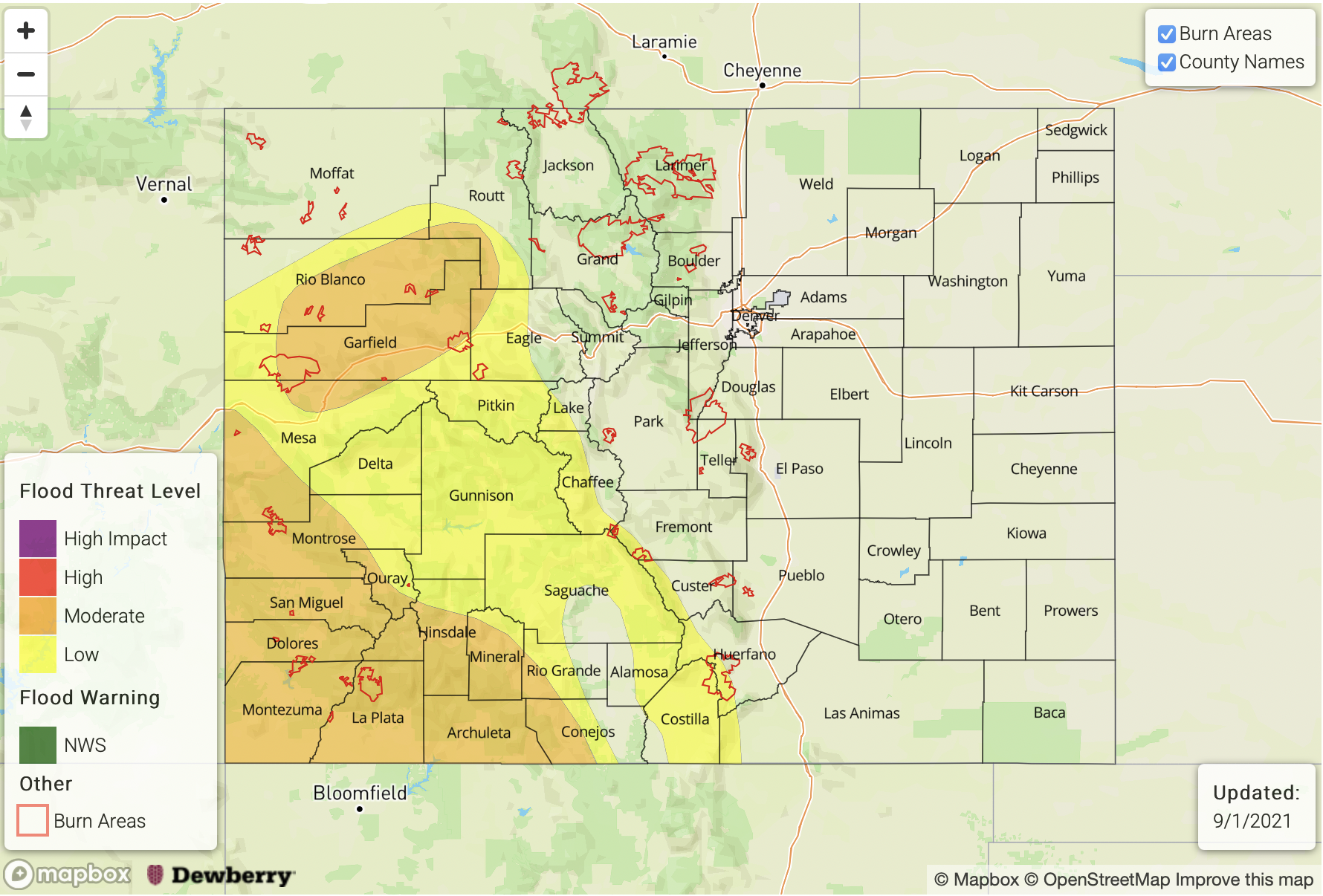
Zone-Specific Forecasts:
San Juan Mountains, Southeast Mountains, Southwest Slope, Central Mountains, San Luis Valley, Raton Ridge, Grand Valley, Northwest Slope & Northern Mountains:
Longer duration rainfall (3 to 6 hour), in a high moisture environment and with extra dynamics overhead may cause some localized flooding issues over the next 24-hours. Expect this mornings storms to expand in coverage and intensity around noon. By morning, isolated totals up to 3.50 inches may be possible with 3-hour rainfall rates reaching around 2 inches in the MODERATE flood threat area this afternoon/evening. This could cause mud flows, debris slides and excessive runoff over steeper terrains, especially as soils become saturated in areas where training storms set up. Other flood threats include flooding of roads and low-lying areas. A couple stronger storms may develop south with the main threats being lightning and embedded convection. Back over the Southeast Mountains, accumulations will be slightly lower with isolated storm totals up to 3 inches possible by morning. With the dry boundary layer, the initial storms that develop may produce some strong outflow winds. A LOW flood threat has been issued for this area. Storms are expected to continue into the evening hours, but should decrease in intensity shortly after sundown.
Primetime: Ongoing to Ongoing (limited to central, western CO tomorrow morning)
Southeast Plains, Northeast Plains, Front Range, Urban Corridor & Palmer Ridge:
Downsloping winds with the lee surface trough will limit precipitation chances further north. Best chance for storms today will be along a surface trough over the eastern plains. Max 1-hour rain rates up to 1.25 inches will be possible. In addition to this rainfall, small hail and strong outflow winds are likely. With dry low-levels and fast steering flows, storms are not anticipated to cause any flooding issues. A second wave of rainfall may arrive to the southern portion of eastern Colorado tonight, which may produce localized totals up to 0.50 inches.
Primetime: 2PM to 4AM