Issue Date: Monday, August 30th, 2021
Issue Time: 10:00 AM MDT
Summary:
Sunday was much cooler to wrap up the weekend, for the eastern half of Colorado at least. High temperatures were 10 degrees or more cooler than Saturday, with highs in the 70s and low 80s for much of Eastern Colorado. However, the Western Slopes and Grand Valley remained hot with highs in the high 80s and low 90s.
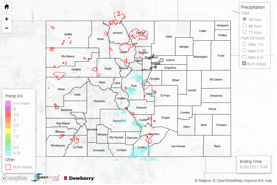
In terms of precipitation, Colorado was largely dry aside from isolated thunderstorms aided by a plume of monsoonal moisture that inched up from the south to the Southeast Mountains, San Juan Mountains, and southern portions of the Central and Front Range Mountains. Storms and showers were isolated, but those areas lucky enough to be under a cell received moderate rain and at times hail and high winds.
Two instances of large hail were reported following thunderstorms in Park County. Between 0.5-1.25 inch hail stones were reported at Red Hill Pass and in Jefferson. Precipitation totals around Jefferson were only about 0.12 inches of rain, but a few other nearby locations received more including: 0.23 inches reported above Cheesman Lake, and 0.43 inches in Lost Park. Further southwest, 0.54 inches of rain was reported at Saguache Municipal Airport from a quick afternoon thunderstorm. A nearby CoCoRaHS observer also reported 0.26 inches after “rain fell fairly hard for about 45 to 50 minutes…beginning about 3:45 pm.”
In Manitou Springs, between 0.12-0.50 inches fell across town in just over an hour yesterday afternoon. The same cell that produced some moderate rain at lower elevations also produced hail and graupel at higher elevations on Pikes Peak. Graupel, sometimes called “soft hail”, is the result of ice deposition on a snow crystal. The Pueblo WFO shared the following tweet with pictures of the summit of Pikes Peak blanketed in hail/graupel.
A thunderstorm brought some hail and graupel to Pikes Peak around 6 pm on Sunday August 29th! #cowx pic.twitter.com/NKb1JHYIoL
— NWS Pueblo (@NWSPueblo) August 30, 2021
Also on Sunday, a fire of unknown cause started in Grand County, Northeast of Kremmling. It has been named the Black Mountain Fire and has burned approximately 150 acres since yesterday afternoon. More information about the fire can be found here, however it is limited due to how recently the fire started.
No flooding was reported on Sunday. For rainfall estimates in your area, check out the State Precipitation Map below.
Click Here For Map Overview
Note: The 24-hour, 48-hour and 72-hour total precipitation do not contain bias corrections today due to errors in the CoCoRaHS data. This means there may be underestimations in QPE over the southwest and southeast corners of the state.
