Issue Date: Monday, August 30th, 2021
Issue Time: 9:20AM MDT
— Flooding is NOT expected today
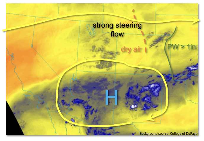
As shown in the water vapor image, below, yesterday’s zonal flow across Colorado has shifted northward, leaving our state in between two main features. To the south, a relatively weak monsoon ridge, with some residual boundary layer moisture, will cause isolated storms over the very high terrain along the NM border. However, only short-term moderate intensity rainfall is expected, so no flood threat is needed here. Further north, a jet streak over WY will guide a weak disturbance across mainly northern and eastern CO this afternoon and evening. Moisture will be the limiting factor for today’s rainfall chances. This morning’s Precipitable Water (PW) at Denver was 0.59 inches, down notably from yesterday’s 0.80. Over the western slope, Grand Junction’s morning PW continued to be far below seasonal normal at 0.46 inches. Pockets of much drier air have also infiltrated parts of central Colorado with very shallow moisture profiles noted along most of the Front Range. With a sharp moisture gradient developing over eastern Colorado, we expect a dryline-type convergence zone over the Northeast Plains and Southeast Plains this afternoon and evening. Strong shear moving into the area this afternoon suggests a few storms will have severe potential for large hail and gusty winds. However, westerly steering flow will also increase throughout the day as the incoming disturbance passes through the area. Short-term heavy rainfall will be possible but flooding is NOT expected today.
Today’s Flood Threat Map
For more information on today’s flood threat, see the map below. If there is a threat, hover over the threat areas for more details, and click on burn areas to learn more about them. For Zone-Specific forecasts, scroll below the threat map.
Zone-Specific Forecasts:
Northeast Plains and Southeast Plains:
Much warmer today with widely scattered showers and storms mainly north of I-70. Max 1-hour rainfall up to 1.5 inches is possible, which could lead to nuisance ponding. However, flooding is NOT expected today. Large hail and damaging winds will be possible with the strongest storms.
Primetime: 4PM through 10PM
San Luis Valley, Raton Ridge, Southeast Mountains, Southwest Slope and San Juan Mountains:
Seasonably warm with isolated to widely scattered showers and weak storms mainly over the higher terrain along the NM border. Max 1-hour rainfall up to 0.6 inches possible. However, flooding is NOT expected today.
Primetime: 1PM to 8PM
Grand Valley, Northwest Slope, Central Mountains, Northern Mountains, Urban Corridor, Palmer Ridge and Front Range:
Hot and mainly dry today with an isolated shower or weak storm possible mainly over the higher terrain along and west of the Continental Divide. Max 1-hour rainfall up to 0.3 inches. Flooding is NOT expected today.
Primetime: 1PM to 7PM