Issue Date: Sunday, August 29th, 2021
Issue Time: 10:15AM MDT
— A LOW flood threat has been issued for the Front Range, Urban Corridor and western Palmer Ridge
It’s a cool and cloudy start to the morning over eastern CO behind yesterday’s cold front. Morning temperatures are running around 8-12F cooler than this time yesterday for most locations. Lower-level moisture has also returned behind the front, and PW at Denver was measured at 0.86 inches. Also noticeable in the sounding was a strong cap right above 700mb, which will help to limit the chance for precipitation north today. The front has had little affect over western CO where PW remains around 0.40 inches. It is likely that PW near the southern border is probably slightly higher, so another round of diurnally driven, scattered storms will be possible over the southern San Juan Mountains. Otherwise, it should remain dry with smoky conditions continuing.
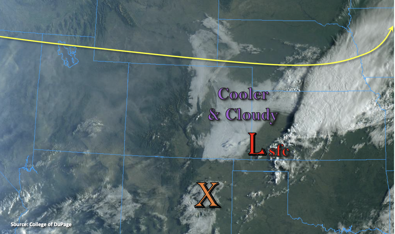
Flow aloft across the state will be zonal behind the trough, and only minimal mid-level energy is forecast to move through this flow. That means the cap will likely not be broken over the northern portion of the Front Range/Urban Corridor. Best chances for post-frontal upslope flow storms to develop will be over the southern Front Range/Palmer Ridge intersect, Southeast Mountains and western Raton Ridge where clearing began earlier in the day. There is a chance for a stronger storm or two to develop over the Palmer Ridge/southern Front Range, if mid-level energy with decent daytime heating can break the cap. Guidance this morning is showing higher confidence in this solution. With the increase in low-level moisture behind the front and slower steering flows aloft, if storms develop, heavy rainfall and localized flooding issues would likely accompany them. So, a LOW flood threat has been issued for this possibility. Elsewhere, rain rates from storms today should be on the lower end, so flooding is not expected.
Today’s Flood Threat Map
For more information on today’s flood threat, see the map below. If there is a threat, hover over the threat areas for more details, and click on burn areas to learn more about them. For Zone-Specific forecasts, scroll below the threat map.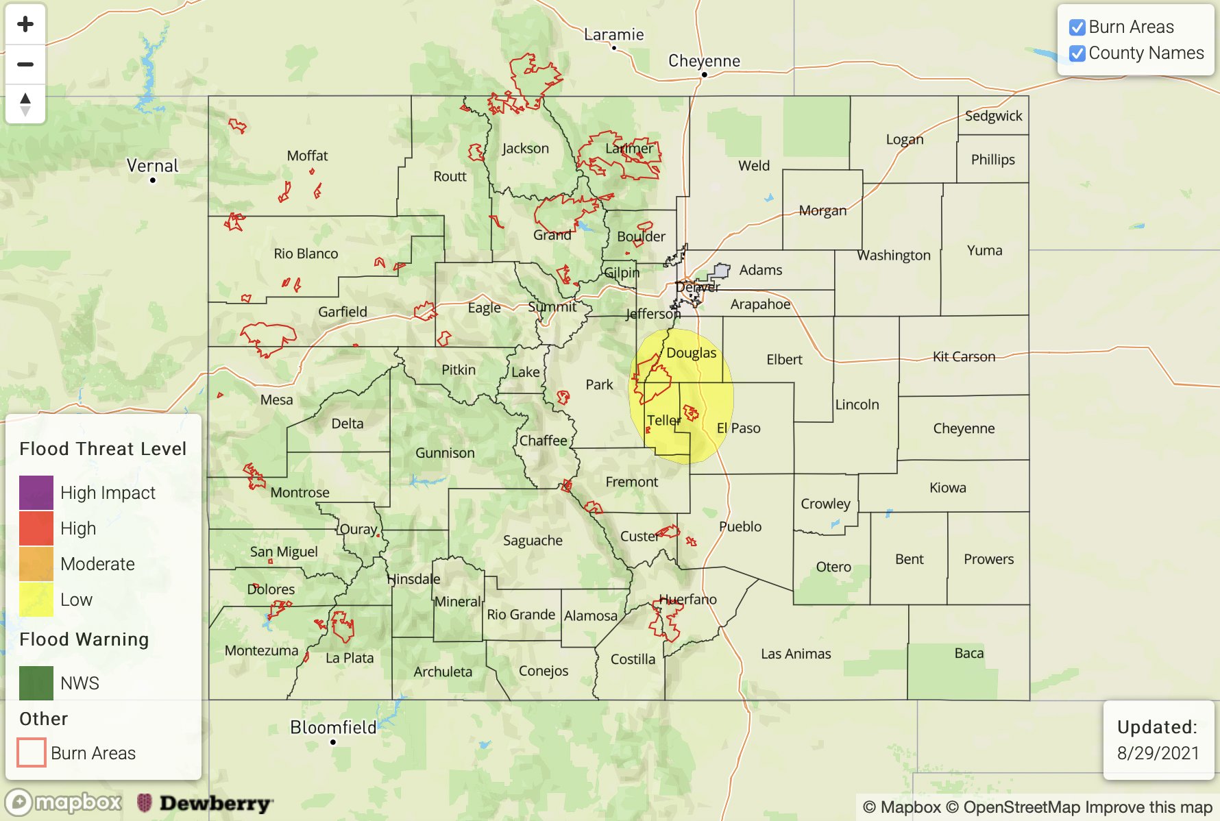
Front Range, San Juan Mountains, Southeast Mountains, Palmer Ridge, Raton Ridge, Urban Corridor, Northeast Plains & Southeast Plains:
Best chance for post-frontal upslope flow storm development today will be over the western Palmer Ridge, southern Front Range, Southeast Mountains and western Raton Ridge. If a storm can break through the cap over the Palmer Ridge/Front Range intersect, heavy rainfall will be possible with max 1-2 hour rainfall totals up to 1.40 inches. A LOW flood threat has been issued for this reason. Elsewhere, rainfall rates should be more gradual with storm totals just under an inch possible. Additional mountain, scattered storms will likely form over the southern San Juan Mountains where max 1-hour rain rates up to 0.75 inches will be possible. Finally, it will be possible for an isolated storm or two to develop over the far Southeast Plains along a trough axis, but confidence in this occurring is low. If it does, isolated storm totals up to 1.50 inches may occur, so flooding issues would not be likely.
Primetime: 1PM to 10PM
Southwest Slope, Central Mountains, San Luis Valley, Grand Valley, Northwest Slope & Northern Mountains:
It will be another smoke-filled and dry day for much of the western portion of the state. Near surface smoke may mix out a bit over the lower elevations by this afternoon, but it will likely remain thick over the Northern Mountains. Afternoon highs will reach into the 90Fs for the lower elevations and upper 80Fs for the mountain valleys. A couple storms off the high terrains may spill into the San Luis Valley this evening, but more wind than rainfall is likely as storms advance away from the source of lift. Isolated storm totals on the edges of the SLV up to 0.35 inches will be possible. Elsewhere, rainfall is not forecast today.