Issue Date: Sunday, August 29th, 2021
Issue Time: 10:00 AM MDT
Summary:
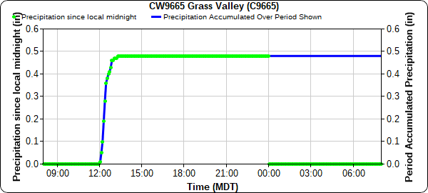
Saturday morning kicked off with a weak cold-front entering the northeast corner of the state, producing a bit of convection ahead of it but very little in terms of precipitation along the Colorado-Nebraska border. Then in the early afternoon scattered showers and thunderstorms began to form in the San Juan Mountains, San Luis Valley, and Southeast Mountains. As the afternoon progressed, southern showers became more widespread, and some convection also built up with the daytime heating along the Front Range Mountains before spilling into the Urban Corridor. If any significant precipitation fell, it was in Southern Colorado: 0.40 was reported in Pagosa Springs by a CoCoRaHS observer, and a quick 0.48 inches was recorded at a APRSWXNET station near Zamara just after noon yesterday (Las Animas County, Grass Valley Station below). A second cold-frontal passage in the evening hours and overnight cooled off the Eastern half of the state, again with little precipitation. Western Colorado remained hot and dry.
The bigger weather story of the day was the impressive heat across Southern Colorado. Records were broken in Alamosa and Colorado Springs, and record-tying heat was reported in Pueblo – the Pueblo WFO shared the following tweets after each record was broken or tied.
As of 1 pm, the temperature has reached 94 degrees in Colorado Springs. This sets a new daily record high temperature for August 28th, surpassing the previous record of 93F, set in 1958. With a few more hours of heating to go, this record may continue to go up! #cowx
— NWS Pueblo (@NWSPueblo) August 28, 2021
At 328 pm, the temperature hit 87 degrees in Alamosa, Colorado. This ties the record high temperature for August 28th, of 87 degrees set in 2011. With a few more hours of heating to go, this record may be broken! #cowx
— NWS Pueblo (@NWSPueblo) August 28, 2021
At 323 pm, the temperature touched 100 degrees in Pueblo, Colorado. This ties the record high temperature for August 28th, of 100F set in 1970. With a few more hours of heating to go, this record may be broken! #cowx
— NWS Pueblo (@NWSPueblo) August 28, 2021
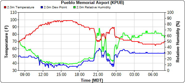
For the second time this summer, the Pueblo WFO also experienced a heat burst before the evening cold-frontal passage. The heat burst was caused by a thunderstorm northeast of Pueblo dissipating and forcing hot, dry air to the surface in the downdraft. This can be seen in the temperature time series from KPUB below, with temperatures rapidly increasing after 9:00 pm up to nearly 90 degrees before 11:00 pm. Temperatures then rapidly decrease again as the cold front passed through the area after 11:00. The Pueblo Airport reported up to 0.29 inches of rain with the initial heat-burst causing thunderstorm. More information about heat bursts can be found here.
No flooding was reported on Saturday. For rainfall estimates in your area, check out the State Precipitation Map below.
Click Here For Map Overview


