Issue Date: Saturday, August 28th, 2021
Issue Time: 10:15AM MDT
— A LOW flood threat has been issued for the Palmer Ridge, Northeast Plains and Southeast Plains
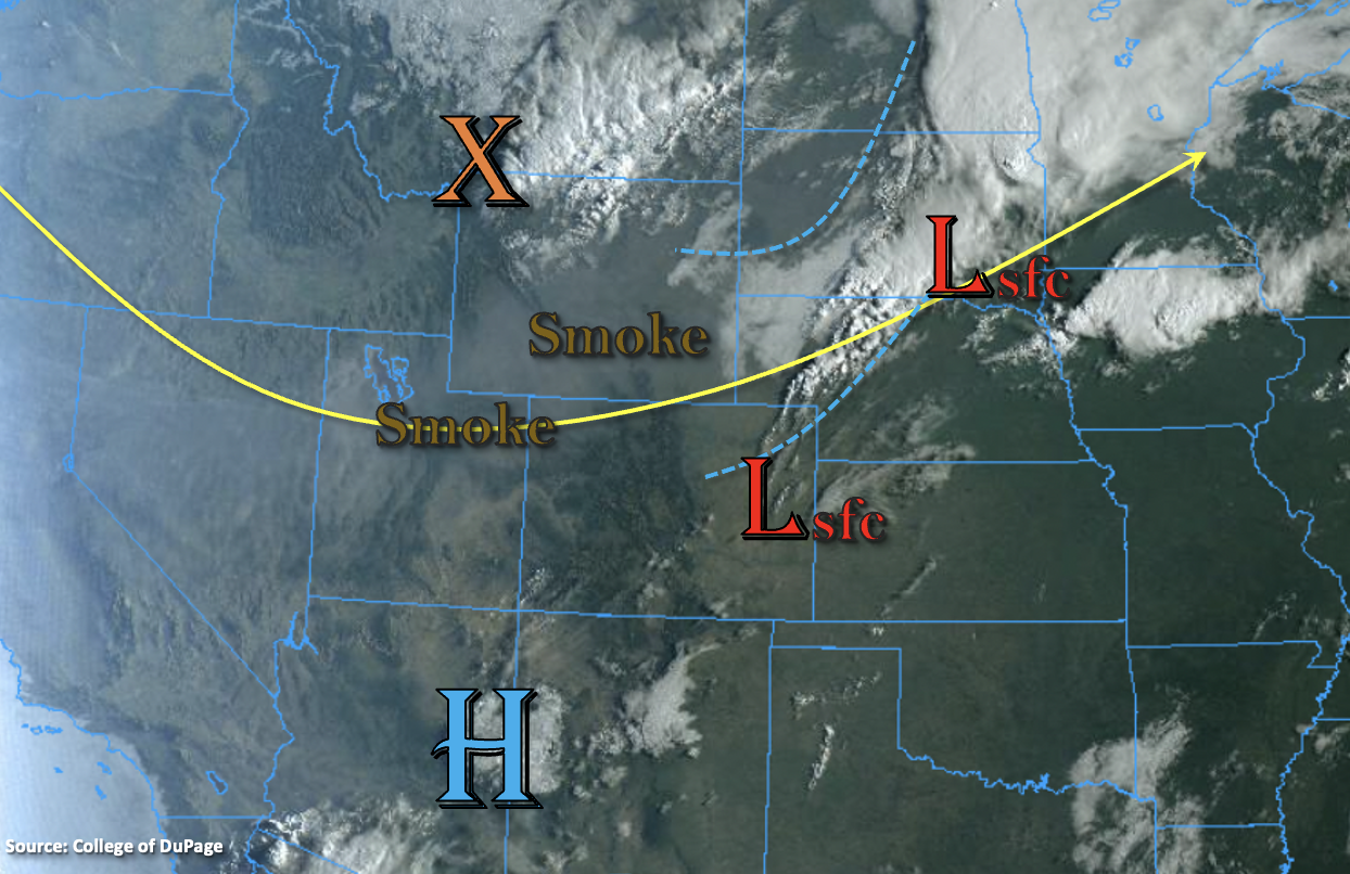
A “cold” front has moved into the northeast corner of the state this morning, but it won’t do much cooling with high temperatures over the area still reaching around 90F. This feature should be stationary throughout the day, and northerly winds behind the boundary will likely pull the plume of smoke, marked below, across the region. Today, the base of the trough (to our north) moves eastward, and flow aloft becomes more zonal (westerly). This drier flow should help to scour out any remaining surface moisture and any new moisture return behind this morning’s front. This set up is expected to keep afternoon rainfall activity on the quieter side with only scattered, high-based storms developing over the mountains and elevated ridges (west), similar to yesterday. The tightening surface gradient will also produce some gusty, westerly surface winds over the Northern Mountains where a Red Flag Warning has been issued.
Tonight, a second surge of cooler air will push through eastern Colorado associated with the trough. This cold front is forecast to not only generate much cooler temperatures tomorrow, but it will likely produce 35 to 45 mph gusts as it slides south. The higher wind gusts will be most likely over the adjacent and far eastern plains during the evening and overnight hours. Moisture is also expected to increase along and behind the front, so it may generate some evening storms and showers. Best chance for a couple of vigorous thunderstorms to develop will be over the eastern plains with more general showers forecast back to the west. The main forecast question for today is the amount of instability that will be over the eastern plains when the lift from the front arrives. Since there is the possibility of a couple stronger storms in a high moisture environment with enhanced convergence along the boundary, a LOW flood threat has been issued. Localized flooding threats include road/low-lying area flooding and field ponding.
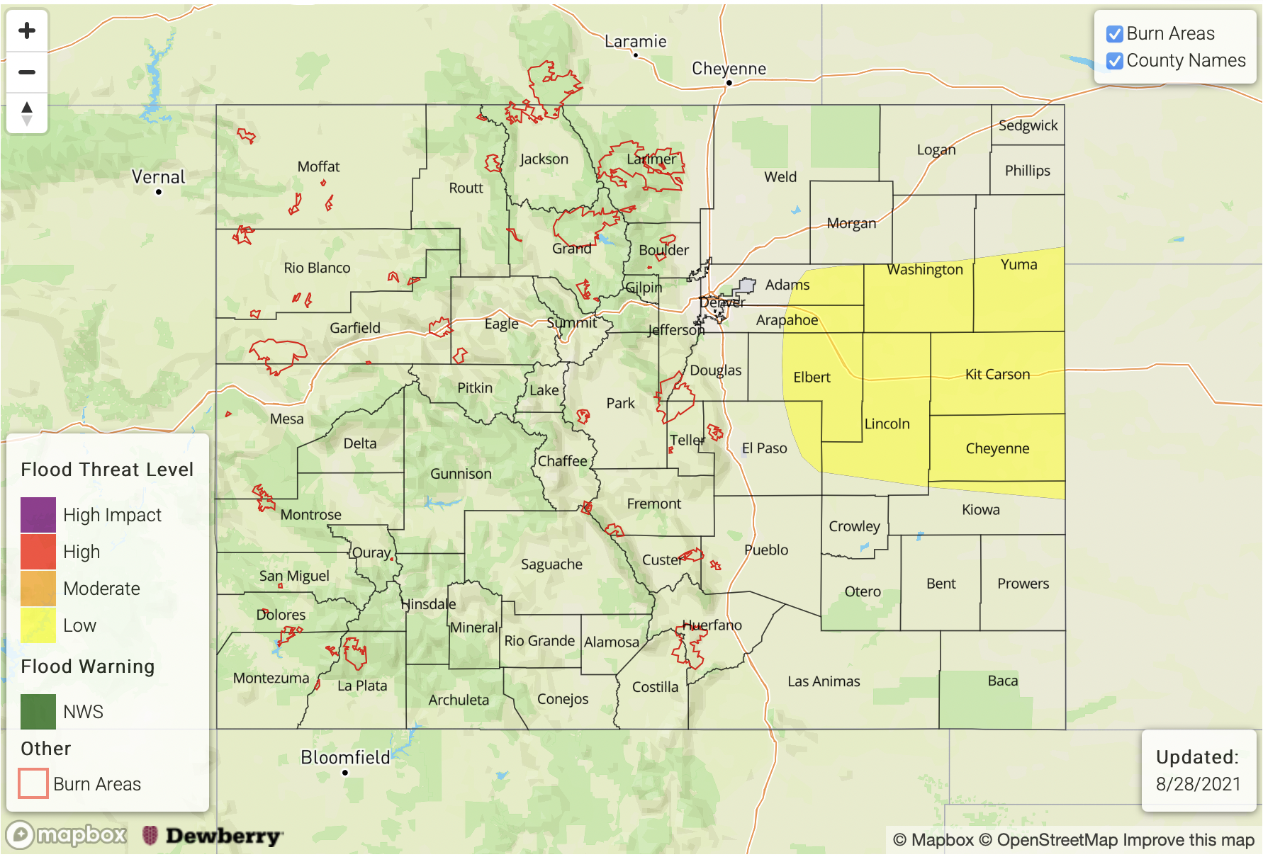
Today’s Flood Threat Map
For more information on today’s flood threat, see the map below. If there is a threat, hover over the threat areas for more details, and click on burn areas to learn more about them. For Zone-Specific forecasts, scroll below the threat map.
Zone-Specific Forecasts:
Southeast Plains, Northeast Plains & Palmer Ridge:
A couple stronger storms may develop over this area this evening and overnight as lift from the front moves south. With high moisture in place from the surface Low, and enhanced convergence along the boundary, storms that develop may be capable of causing localized flooding issues. Max 1-hour rain rates up to 1.75 inches and storm totals up to 2.50 inches will be possible. If the storms develop, they could cause localized road flooding, local stream/creek bankfull conditions, field ponding and flooding of low-lying areas. A LOW flood threat has been issued.
Primetime: 6PM to 3AM
San Juan Mountains, Southeast Mountains, Front Range, Southwest Slope, Central Mountains, San Luis Valley, Raton Ridge, Urban Corridor, Grand Valley, Northwest Slope & Northern Mountains:
Not much rainfall expected this afternoon though some moderate showers with lightning may develop across the southern high terrains again, both east and west. Other than that, western CO should remain dry. Over the elevated ridges (east) and southern Front Range, showers accumulations are forecast on the lower end with the downscoping flow aloft. Max 1-hour rain rates up to 0.50 inches (west/south) and 0.25 inches (adjacent plains) will be possible. Additional showers may develop over the eastern high terrains and immediate adjacent plains overnight as the cold front drops south. With the dry low-levels and decreasing instability, storms are only expected to produce light to moderate showers. Flooding is NOT forecast today.