Issue Date: Wednesday, August 25th, 2021
Issue Time: 10AM MDT
— A LOW flood threat has been issued for the Northeast Plains, Palmer Ridge and Urban Corridor
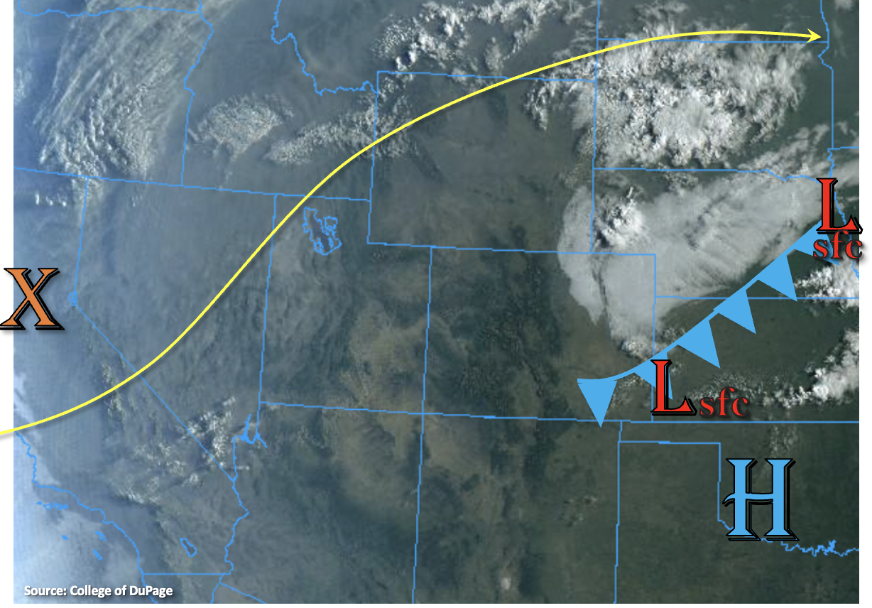
Shown in the visible satellite imagery below is a lot of fog and cloud cover over the northeast corner of the state behind a cold front. The passage of the front will help to keep afternoon temperatures a few degrees cooler when compared to the last couple of days. With decent moisture return behind the front, PW at Denver has risen to 0.68 inches and increases to around an inch over the plains. A surface Low over the Southeast Plains will help to hold this moisture in place on its north and east side with east and southeast surface winds, which will help set the stage for the possibility of later PM storms. Best chance to break the cap will be over the Palmer Ridge this evening/tonight, and northeast movement of the isolated storms should allow the thunderstorms that develop to spread into the Northeast Plains overnight. There may be enough mid-level energy moving through the flow to pop some additional late afternoon storms along the Southeast Plains trough axis as well. Lower-end steering flow over the area, an increase in low-level moisture and an increase in upper dynamics may cause some localized flooding issues under the stronger storm cores that develop, so a LOW flood threat has been issued.
For western Colorado, the trough to our west will continue to move eastward throughout the day. As mid-level lift and moisture arrives late tonight and into tomorrow morning expect some light showers to develop over the area. Today however, windy and dry conditions continue, and a Red Flag Warning has been re-issued for Moffat County.
Today’s Flood Threat Map
For more information on today’s flood threat, see the map below. If there is a threat, hover over the threat areas for more details, and click on burn areas to learn more about them. For Zone-Specific forecasts, scroll below the threat map.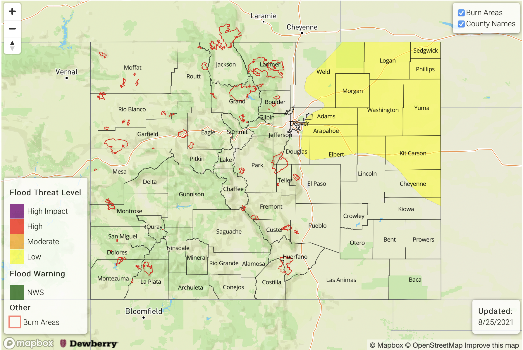
Zone-Specific Forecasts:
Palmer Ridge, Southeast Plains, Northeast Plains & Urban Corridor:
Biggest difference to note about storms today is their later development. It will take a bit for the cap to break, so don’t expect the first round of storms until late this afternoon and evening. There’s some uncertainty where an isolated storm or two will be able to break the cap, but the highest likelihood is over the Palmer Ridge. As storms move northeast, outflow boundaries could trigger additional convection in the moisture rich environment for scattered storm coverage. Max 1-hour rain rates up to 1.25 inches (west) and 2 inches (east) with slightly higher storm totals are possible (1.40 inches and 2.50 inches, respectively). This could cause road flooding, field ponding and flooding of local streams and creeks. A LOW flood threat has been issued, which continues into the overnight hours. Additional storms could develop over the far Southeast Plains late this afternoon, and if they develop, these storms would be capable of producing storm totals up to 1 inch.
Primetime: 4:30PM to 2:30AM
San Juan Mountains, Southwest Slope, Central Mountains, Southeast Mountains, Front Range, San Luis Valley, Raton Ridge, Grand Valley, Northwest Slope & Northern Mountains:
It will likely be too dry today for rainfall over these forecast regions today. Some late night/early morning light showers will be possible across the western border area as the trough arrives. Rainfall should pick up tomorrow as this trough moves overhead. Today, dry, hot and breezy conditions continue. A Red Flag Warning has been issued for Moffat County with the jet overhead and tightening surface gradient. Southwest surface winds are forecast to be in the 10 to 20 mph range with gusts up to 30 mph possible. Flooding is NOT forecast.