Issue Date: Friday, August 20th, 2021
Issue Time: 9:30AM MDT
— Flooding is NOT expected today
— A PM forecast update is possible today.
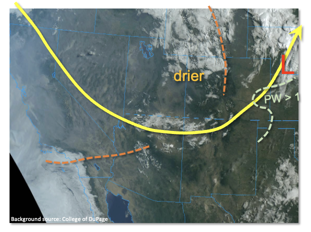
As shown in the visible satellite image, below, a strong trough is currently positioned right over Colorado allowing for the influx of much drier and cooler air into our state. The air is so much cooler that higher elevation locations as low as 10,000 feet received a bit of snow overnight! To the east, a surface low pressure was observed along the KS/NE border, along with an attendant cool front that was racing southward across eastern Colorado. Precipitable Water (PW) has fallen sharply for most areas with Denver’s morning reading at 0.67 inches, and Grand Junction’s at 0.60 inches. PW will continue to fall for all areas except the Southeast Plains where it will stay steady, up to 1 inch, or even increase slightly overnight as easterly low-level winds advect some moisture from KS back into CO.
Dry conditions are expected for most of the state today, along with pleasantly cool temperatures and breezy conditions at times. It will certainly feel a bit like fall! However, an interesting and unusual situation will setup during the late evening and overnight hours over the Southeast Plains and Raton Ridge. Lee-side cyclogenesis is expected over northern New Mexico later this afternoon as another disturbance, currently over CA/AZ, races eastward. This will shift low-level winds from northerly to easterly and allow for a 3-6 hour period of moisture return into Colorado. Depending on moisture availability, there could be enough instability to fuel isolated to scattered showers and storms over the Arkansas River basin. Short-term moderate to possibly heavy rainfall could result as these storms slowly move northward. At this time, flooding is NOT expected but due to the unusual timing of the expected heavy rain (i.e. overnight), an afternoon forecast update is possible today should a flood threat arise.
Today’s Flood Threat Map
For more information on today’s flood threat, see the map below. If there is a threat, hover over the threat areas for more details, and click on burn areas to learn more about them. For Zone-Specific forecasts, scroll below the threat map.

Zone-Specific Forecasts:
Southeast Plains, Palmer Ridge and Raton Ridge:
Cooler and breezy today, with dry conditions expected through early evening. Isolated to scattered showers and thunderstorms are possible beginning late evening and into the overnight hours. Max 1-hour rainfall up to 0.9 inches (Palmer Ridge and Raton Ridge) and up to 1.4 inches (Southeast Plains). This is just below flood threat thresholds, so flooding is NOT expected at the moment. However, an afternoon forecast update is possible if a threat arises.
Primetime: 11PM through 3AM
Grand Valley, Northwest Slope, Central Mountains, Northern Mountains, San Juan Mountains, Southwest Slope, San Luis Valley, Southeast Mountains and Front Range Palmer Ridge, Urban Corridor and Northeast Plains:
Cooler and breezy today with mainly dry conditions. Isolated rain and high-elevation snow showers are possible mainly this morning over the Northern Mountains and Central Mountains. Accumulations will be very light. Overnight, an isolate shower or weak storm cannot be ruled out over the Northeast Plains. Max 1-hour rainfall up to 0.6 inches. Flooding is NOT expected today.
Primetime: 2AM through 5AM