Issue Date: Friday, August 20th, 2021
Issue Time: 10:50 AM MDT
Summary:
Yesterday’s weather across Colorado had it all – heavy rain, severe thunderstorms including large hail and tornadoes, and snow! There’s a lot to cover this morning, starting out west:
The Western Slopes and Grand Valley remained under a plume of monsoonal moisture and northwest flow spinning around the upper level low, resulting in a second day of widespread, long-duration rainfall. Heavy rain caused a debris flow in Uravan in Montrose County on the Southwest Slope, reported yesterday afternoon by CDOT.
COLORADO HIGHWAY 141 HAD ALTERNATING TRAFFIC DUE TO MUDSLIDE CLEAN-UP BETWEEN COUNTY ROAD Y11 AND COUNTY ROAD Q12.
A CoAgMet weather station in Bedrock, 7 miles southeast of the reported debris flow location, reported 2.05 inches in 24-hours yesterday. For this part of the state, 2.05 inches in a day is between a 25-year and 50-year Average Recurrence Interval (or 2%-4% chance of occurrence in any given year). CDOT has reported that CO-141 since reopened.
While no flooding was reported, the last two days of rain in Grand Junction have broken daily records at the airport. A total of 0.47 was reported on the 18th, and 0.68 inches at the time of the following tweet from the Grand Junction WFO. Since then, a total of 0.79 inches was reported at the airport for a 2-day total of 1.26 inches. This falls between a 2-year and 5-year rainfall event for Grand Junction.
The @GJAirport has officially set new daily rainfall records for both August 18th and 19th! Yesterday we received 0.47″ which broke the old record of 0.26″ set in 1989. Today we’ve received 0.68″ (so far!) which breaks the old record of 0.60″ set in 1925! ☔ #cowx
— NWS Grand Junction (@NWSGJT) August 19, 2021
Other notable rainfall totals along the Western Slopes and Grand Valley include:
- 1.66 in Paonia
- 1.60 in Hotchkiss
- 1.56 in Olathe and Redstone
- 1.25 in Montrose
- 1.21 in Carbondale (“the most significant rain event in the 13 years of data collection at this station.”)
- 1.15 in Nucla
- 0.92 in Ridgway
Moving towards the high county in the Northern and Central mountains – a cold-frontal passage associated with the low-pressure system resulted in August snow in the high elevations! The Boulder WFO shared the following tweet, showing snow at Rocky Mountain National Park and Vail Pass. Snow was also reported yesterday at Wolf Creek Pass, Berthoud Pass, and Storm Peak in Steamboat Springs. Trail Ridge Road in Rocky Mountain National Park was closed due to white out conditions.
Say it ain’t snow! ❄️
Yesterday, some of our mountain areas received some summer snowfall. (Left: Alpine Visitor Center in @RockyNPS) (Right: Vail Pass on I-70) #COwx pic.twitter.com/wHAH1wesFC— NWS Boulder (@NWSBoulder) August 20, 2021
I-70 through Glenwood Canyon remained closed for the entire day yesterday due to the threat of flooding and debris flows. The Glenwood Springs area received over 1.15 inches of precipitation yesterday in the form of long-duration rain most of the day and overnight. Thankfully, no flooding or debris flows were reported along I-70 due to the Grizzly Creek burn scar.
Continuing to the Urban Corridor, the eastward movement of the low-pressure system met with daytime heating ahead of the cold-front to produce two swaths of severe thunderstorms across the northern and southern Denver Metro Area. First up north, a severe-thunderstorm and tornado warned storm traversed the northwest Denver suburbs from Golden to Brighton, producing up to 2.00 inch hail in Golden, a funnel-cloud in Arvada, and 1.95 inches of rain in Brighton! To the south, a similar setup moved southwest to northeast across Castle Rock to Bennet, with over 1.00 inch hail reported all along the storm track, a funnel-cloud in Parker, and over an inch of rain in just an hour in Castle Pines. An additional round of rainfall occurred over the Urban Corridor overnight from the passage of the cold front, boosting 24-hour precipitation totals.
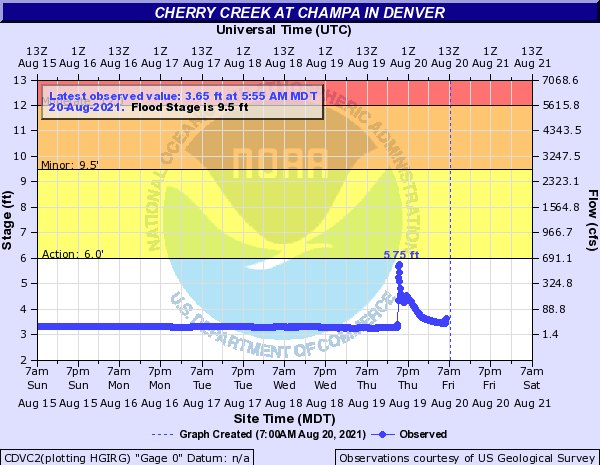
Minor street flooding was reported in Denver, including the Cherry Creek bike trail being overtopped. The Cherry Creek River at Champa gauge briefly reached just below “Action” stage yesterday, peaking at 5.75 feet as seen in the hydrograph below. Other small streams and rivers across the Urban Corridor had similar responses to the heavy rain.
Other notable rainfall totals from the Urban Corridor include:
- 1.28 inches in Fort Lupton
- 1.10 inches Greenwood Village
- Another 1.10 inch observation in Boulder
- 1.05 inches in Highlands Ranch
- 0.87 inches in Littleton
- 0.71 inches in Arvada
Finally, on the Northeast Plains a supercell thunderstorm followed by training thunderstorms over the same area produced heavy rain and flooding in Holyoke and nearby towns. The severe thunderstorm also produced up to 66 mph wind gusts, 0.25-1.00 inch hail, and a tornado on the Colorado-Nebraska border. The following flood reports were made by the public or law enforcement.
SEVERAL HOUSES HAD WATER RISE UP TO THE FRONT DOORS.
SIGNIFICANT STREET FLOODING INCLUDING MAIN STREET IN AND NEAR HOLYOKE.
SIGNIFICANT FLASH FLOODING 6 MILES EAST OF HOLYOKE ON U.S. HIGHWAY 6.
THREE 6 INCH RAIN GAUGES ON HIS FARM OVERFLOWED.
WIDESPREAD FLOODING OF ROADS, DITCHES, AND FIELDS. AT LEAST ONE ROAD CROSSING FRENCHMAN CREEK ARE IMPASSABLE. FRENCHMAN CREEK AND OTHER STREAMS HAVE SIGNIFICANT FLOODING.
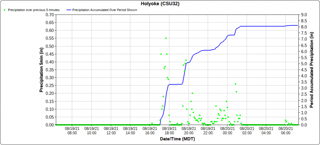
A CoAgMet Station in Holyoke, which was directly impacted by the supercell (tweet below), received 3.26 inches of rain in a single hour! This amounts to between a 100-year and 200-year ARI for this area. The series of storms over this area ultimately dropped 8.11 inches of rain in Holyoke yesterday (as seen in the time series plot below), with 8.06 of that falling within a 12-hour period. The 12-hour, 1000-year ARI (or 0.1% chance of occurrence in any given year) for Holyoke is 6.48 inches, so the 8.06 inches observed from this storm well exceed the 1000-year return interval!
Our station southeast of Holyoke recorded 3.26″ in one hour between 5-6 pm. Flooding being reported, and more heavy rain moving into the area. #cowx @NWSBoulder pic.twitter.com/wrsHRzJ27X
— CoAgMET (@ColoradoMesonet) August 20, 2021
Other notable rainfall totals in the Northeast Plains (although they seem paltry in comparison) include:
- 4.23 in Wray
- 1.95 in Ovid
- 1.70 in Big Springs
- 1.59 in Haxtun
- 1.20 in Iliff
- 0.98 in Yuma
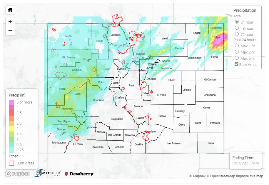
The San Luis Valley, Southeast Mountains, Raton Ridge, and Southeast Plains stayed largely dry yesterday. For rainfall estimates in your area, check out the State Precipitation Map below.
Click Here For Map Overview
The map below shows radar-estimated, rainfall gage-adjusted Quantitative Precipitation Estimates (QPE) across Colorado. The map is updated daily during the operational season (May 1 – Sep 30) by 11AM. The following six layers are currently available: 24-hour, 48-hour and 72-hour total precipitation, as well as maximum 1-hour, 2-hour and 6-hour precipitation over the past 24 hour period (to estimate where flash flooding may have occurred). The accumulation ending time is 7AM of the date shown in the bottom right corner. Also shown optionally are vulnerable fire burn areas (post 2012), which are updated throughout the season to include new, vulnerable burn areas. The home button in the top left corner resets the map to the original zoom.

