Issue Date: Wednesday, August 18th, 2021
Issue Time: 9:15 AM MDT
Summary:
As discussed in yesterday’s FTB, Tuesday was an overall calm day before the incoming pattern change. Scattered afternoon showers developed in the high elevations of the Northern, Central, and Front Range mountains before spilling onto the Urban Corridor, while the Eastern Plains and the southern half of Colorado remained largely dry.
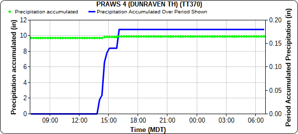
In the Northern and Front Range Mountains, early afternoon flood advisories issued turned to a flash flood warning for portions of the Cameron Peak burn scar and nearby locations in Larimer County. A RAWS station on the southern extent of the burn scar recorded 0.18 inches in an hour, as seen in the precipitation accumulation time series plot below. Thankfully, no flooding was reported.
As storms moved eastward off the mountains, limited available moisture dampened precipitation accumulations from thunderstorms. According to CoCoRaHS and MesoWest observations across the area, only Trace – 0.11 inches of rain fell. Instead, the main phenomena observed were high winds. Thunderstorm wind gusts exceeding 50 mph were reported across the Urban Corridor and adjacent Northeast Plains, from Keenseburg to Castle Rock– including a 63 mph wind gust recorded at KAPA-Centennial Airport.
No flooding was reported on Tuesday. For rainfall estimates in your area, including antecedent conditions, check out the State Precipitation Map below.
Click Here For Map Overview

