Issue Date: Monday, August 16th, 2021
Issue Time: 1:15PM MDT
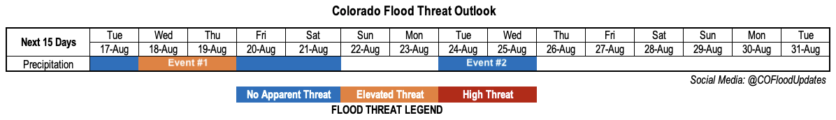
Valid Dates: 8/17-8/31
Fortunately, the ingredients for a widespread rainfall event look to be coming together for Colorado’s Western Slope. This is excellent news for the region, which is currently experiencing the worst drought conditions in the entire state, by far. Unfortunately, there will be an Elevated flood threat with this event, in addition to the chance of severe weather. Let’s get into the details.
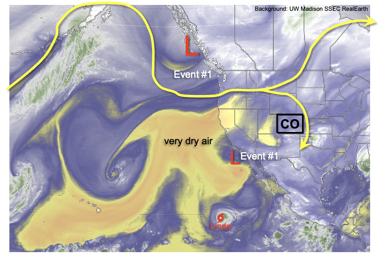
As shown in the water vapor image, below, Colorado remains on the eastern periphery of a weakening upper-level ridge. However, to the northwest, an incoming, initially fast-moving trough (Event #1) will set the stage for very active weather mainly for western Colorado over the next 48-72 hours. As the trough moves SE, it will tap into some sub-tropical (monsoonal) and even tropical moisture that currently exists along the Mexican west coast. Fortunately, the previous Outlook’s concern of a deep tropical moisture feed is unlikely to occur. Nonetheless, a 48 hour period of very high moisture will overspread the entire state. After some isolated showers and storms Tuesday, things quickly pick up by Wednesday as multiple rounds of moderate to heavy rainfall are expected starting in the afternoon and lasting well into the evening, and even into the overnight hours. The prime region on Wednesday will be far western areas, right along the entire Utah border. The trough will actually cross the state on Thursday afternoon and the heavy rainfall threat will move slightly east over the entire high terrain along the Continental Divide. Conditions will quickly improve late Thursday as drier air races into the state.
Severe weather looks like a strong possibility with this system, as deep wind shear will combine with at least moderate instability to support the chance of damaging winds, large hail and even tornadoes on Wednesday and Thursday across the Western Slope. There is also a chance of severe weather over the far northern parts of the Northeast Plains, though most of the action is expected to stay in NE and WY.
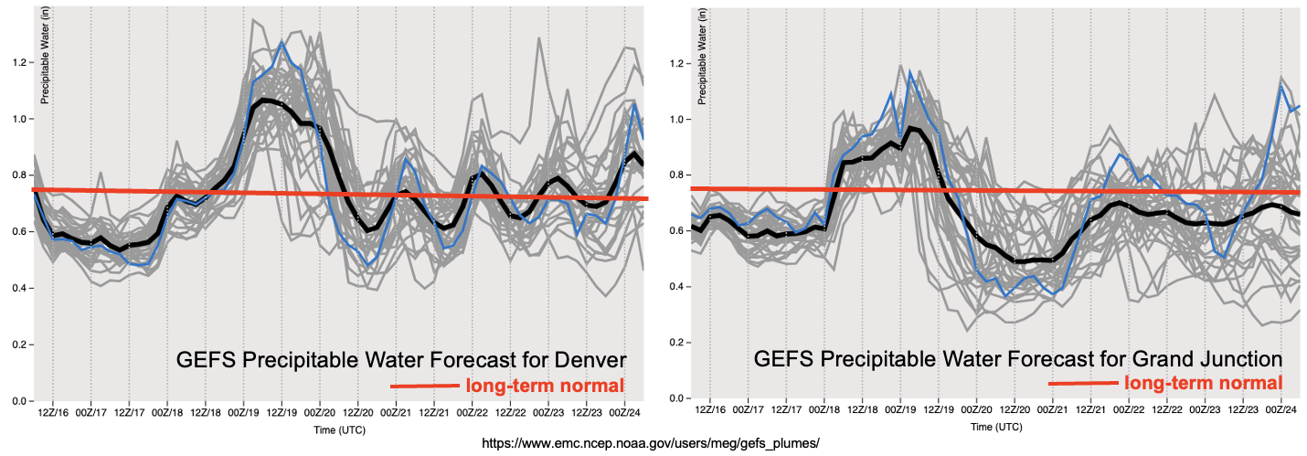
As shown in the forecasted Precipitable Water (PW) plumes, below, moisture quickly drops to at or slightly below seasonal normal level by Friday with isolated weak storms still possible mainly over northern Colorado even into Saturday. By next week, there is significant disagreement in guidance but currently it appears there are a few different pathways to bring rainfall back into the state (Event #2). This includes both monsoonal and non-monsoonal rainfall. Due to the uncertainty, there is currently No Apparent Flood Threat with this event.
The two identified precipitation events are described in more detail below.
Event #1: Tuesday – Saturday (August 17 – August 21)
Elevated Flood Threat On Wednesday And Thursday Across Entire Western Slope
Isolated showers and weak storms are possible over the higher terrain of the Western Slope on Tuesday, but Wednesday is when the much heavier and more widespread precipitation moves in. We expect a few rounds of showers and thunderstorms Wednesday afternoon and evening, especially over far western parts of the Western Slope. Max 1-hour rainfall up to 1.5 inches looks likely, which will support isolated flash flooding, debris slides and mud flows. On Thursday, there is some uncertainty regarding the amount of instability available, which will dictate the type of rainfall. With higher instability, max 1-hour rain rates up to 1.5 inches once again look possible. With lower instability, it will be more of the 3-6 hour rainfall up to 2 inches that could trigger debris slides and mud flows, especially with already saturated soils expected after Wednesday. Overnight moderate to possibly heavy rainfall could also occur both Wednesday and Thursday nights. Overall, the main factor precluding a High threat for this event is the fast steering flow, which will tend to suppress point rainfall totals and keep high rainfall intensity relatively isolated in space.
With strong downsloping winds, rainfall chances are not looking promising for the lower terrain east of the Continental Divide. The best chances of heavy rainfall here will be over the far northern portions of the Northeast Plains where showers and thunderstorms will be possible on Thursday. There will be a chance of severe weather also as strong wind shear and instability will co-exist. However, rainfall over 1.5 inches, which is the rough threshold for flooding, is looking unlikely at this time as storm motion will be rapid and storms will quickly move out of CO into WY/NE.
Conditions will turn much calmer by Friday as significant drying will take place, but with cold temperatures aloft and some retrogression of the upper-level trough, a few showers and weak storms could pop over the northwest quadrant of Colorado. These are unlikely to pose a flood threat. Similar conditions are expected on Saturday, as the trough of low pressure slowly weakens.
Event #2: Tuesday – Wednesday (August 24 – August 25)
Precipitation Chances To Increase; Flood Threat Highly Uncertain So No Apparent Threat At This Time
At this time, some guidance is suggesting a monsoonal moisture plume that will mainly affect western Colorado. Other guidance is showing frontal-type precipitation that will affect mainly eastern Colorado. Regardless of the eventual outcome, an increase in rainfall chances looks likely, but more details will follow in Thursday’s Outlook.