Issue Date: Monday, August 16th, 2021
Issue Time: 9:30 AM MDT
Summary:
Those on the Northeast Plains woke up yesterday to an early morning line of thunderstorms moving southeast between the I-76 and I-70 corridors. As discussed in yesterday’s FTB, this was unusual for anywhere in Colorado this time of year, but it was indicative of the moisture available for showers and thunderstorms throughout the day. By early afternoon, widespread storms began to fire up along the high elevations of the Northern, Central, San Juan, Southeast and Front Range Mountains, before expanding into the Southwest Slope, Palmer Ridge, and Southeast Plains by evening.
Along the Urban Corridor, the Colorado Springs area received between 0.10-0.77 inches of rainfall across town, according to various observation networks, thanks to an initial strong afternoon thunderstorm and then lingering light precipitation though the evening.
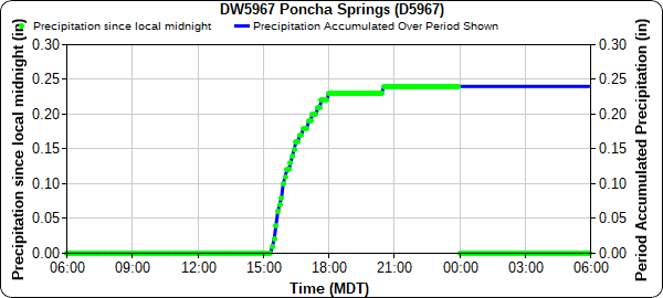
In the Central Mountains, two flash flood warnings were issued after heavy rain was indicated over Poncha Pass and Chalk Cliffs in Chaffee County. A MesoWest station in Poncha Springs reported 0.24 inches of precipitation, as seen in the time series plot below. The heaviest rain fell in a short period between 3:00 and 6:00 pm. Nearby in Salida, a PWS reported 0.25 inches for the day. Thankfully no flooding was reported on Poncha Pass, the Decker burn scar, or the Chalk Cliffs – one of the most debris-flow prone areas of the state.
Afternoon storms also prompted a flood advisory to be issued for Grand Lake and some of the East Troublesome burn area. Two MesoWest stations around Grand Lake both picked up 0.22 inches in a short period just before 3 pm, however no flooding was reported in Grand Lake as well.
Still, forecasted rain, thunderstorms, and the potential for debris flows resulted in preventative measures taken by CDOT. A long stretch of I-70 was briefly closed between Dotsero and Rifle, including Glenwood Canyon; and CO-5/Mount Evans Road remains closed after “adverse weather” prompted a safety closure. No flooding has been reported in Glenwood Canyon from the Grizzly Creek scar or along Mount Evans Road.
On the southwest slope, high winds were reported in Montrose and Cortez overnight and into the early morning after rounds of thunderstorms. A CoCoRaHS observer in Hesperus (La Plata County) reported 0.87 inches of precipitation from several rounds of storms, including pea-sized hail. The Durango area received between 0.25-0.55 inches as well.
For rainfall estimates in your area, check out the State Precipitation Map below.
Click Here For Map Overview
The map below shows radar-estimated, rainfall gage-adjusted Quantitative Precipitation Estimates (QPE) across Colorado. The map is updated daily during the operational season (May 1 – Sep 30) by 11AM. The following six layers are currently available: 24-hour, 48-hour and 72-hour total precipitation, as well as maximum 1-hour, 2-hour and 6-hour precipitation over the past 24 hour period (to estimate where flash flooding may have occurred). The accumulation ending time is 7AM of the date shown in the bottom right corner. Also shown optionally are vulnerable fire burn areas (post 2012), which are updated throughout the season to include new, vulnerable burn areas. The home button in the top left corner resets the map to the original zoom.

