Issue Date: Saturday, August 14th, 2021
Issue Time: 9:05 AM MDT
Summary:
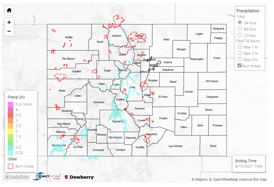
Moisture circling around the high-pressure ridge to the west brought southerly flow and early afternoon scattered thunderstorms to the high elevations of the Northern, Central, and San Juan mountains yesterday. As the afternoon progressed, showers spilled onto the Front Range Mountains and Urban Corridor, as well as filled in in the Southwest Slope.
The Southwest Slope benefited the most from the additional surge of monsoonal moisture. Between 0.25-0.78 inches were reported from various networks around Cortez and Mancos in Montezuma County. A bit to the northeast, a short-lived thunderstorm produced up to 0.34 inches of rain and small hail in Saguache. The CoCoRaHS observer left the following remark, indicating most of the rain fell in just half an hour:
Rain started as sprinkles about 4:50 p.m. About 4:55 it became heavy and lasted about 25 minutes. Hail (approximately 1/4 inch) started after the rain (about 5:10) and lasted for 5 minutes. The storm was over by 5:30. The temperature dropped 20 degrees from the storm–from 80 to 60 degrees
Flash flood warnings were issued for portions of the East Troublesome and Cameron Peak burn scars in the Northern and Front Range Mountains, but ultimately no flooding was reported. Rainfall accumulations were between 0.10-0.25 inches across each of the burn areas, which is just below the threshold for the State Precipitation Map below.
Yesterday also had the potential for severe weather on the Eastern Plains and Palmer Ridge, however there was too much stability to overcome and storms never materialized – to the disappointment of many who were hoping to chase, or at least get to see some excitement, near the Colorado-Wyoming border.
For rainfall estimates in your area, check out the State Precipitation Map below.
Click Here For Map Overview
The map below shows radar-estimated, rainfall gage-adjusted Quantitative Precipitation Estimates (QPE) across Colorado. The map is updated daily during the operational season (May 1 – Sep 30) by 11AM. The following six layers are currently available: 24-hour, 48-hour and 72-hour total precipitation, as well as maximum 1-hour, 2-hour and 6-hour precipitation over the past 24 hour period (to estimate where flash flooding may have occurred). The accumulation ending time is 7AM of the date shown in the bottom right corner. Also shown optionally are vulnerable fire burn areas (post 2012), which are updated throughout the season to include new, vulnerable burn areas. The home button in the top left corner resets the map to the original zoom.
