Issue Date: 8/7/2015
Issue Time: 9:40 AM
A MODERATE FLOOD THREAT IS FORECAST FOR PORTIONS OF THE NORTHEAST PLAINS AND PALMER RIDGE.
A LOW FLOOD THREAT IS FORECAST FOR PORTIONS OF THE SOUTHWEST SLOPE, SAN JUAN MOUNTAINS, GRAND VALLEY, URBAN CORRIDOR, SOUTHEAST PLAINS, RATON RIDGE, AND PALMER RIDGE.
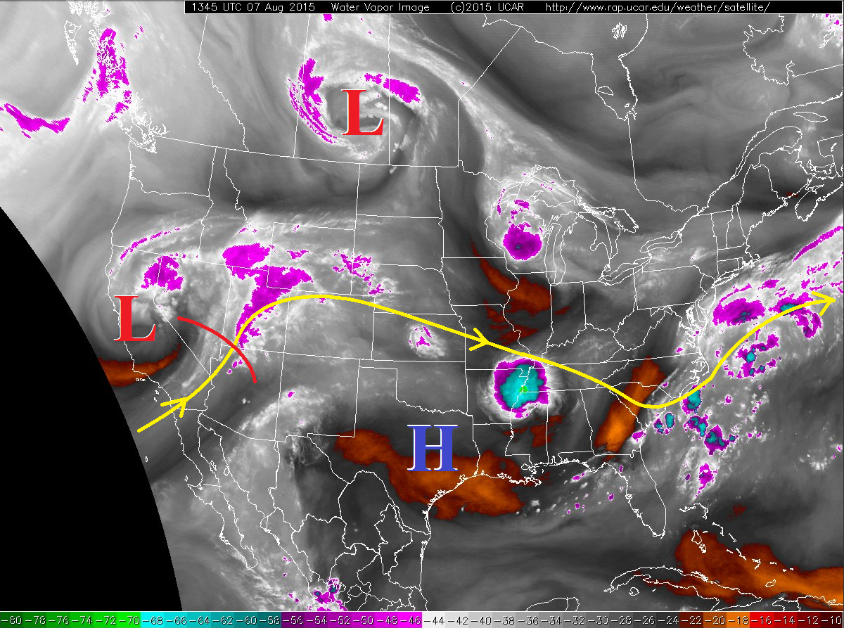
Today will be quite the change from the last two days with scattered thunderstorms expected across much of the state. A quick glance at the water vapor imagery shows the increase in moisture from southwesterly flow aloft as the upper-level high pressure has been pushed back to the east by the approaching upper-level low. This increase in moisture will provide the fuel for thunderstorm development. A disturbance (marked by the red line over NV/UT/AZ) will rotate across Colorado today, providing background support for a fairly active day. Severe thunderstorms will be possible across Southwest Slope and Grand Valley regions (mainly a severe wind threat), and across the Northeast Plains, Southeast Plains, and Palmer Ridge regions. Severe storms over eastern Colorado will hold a mixed bag of threats thanks to ample instability/moisture/wind shear, with isolated tornadoes, severe winds, large hail, and heavy rain capable of flash flooding.
Most of the activity will follow the typical diurnal pattern and diminish after sunset, but isolated-to-scattered showers will likely continue overnight across the Grand Valley, Central Mountains, San Juan Mountains, and Southwest Slope regions. Additionally, as storms work eastward across the plains towards KS/NE, it could be midnight, or just after, before they exit the state.
Today’s Flood Threat Map
For more information on today’s flood threat, see the map below (hover over threat areas for more details). For Zone-Specific forecasts, jump below the map.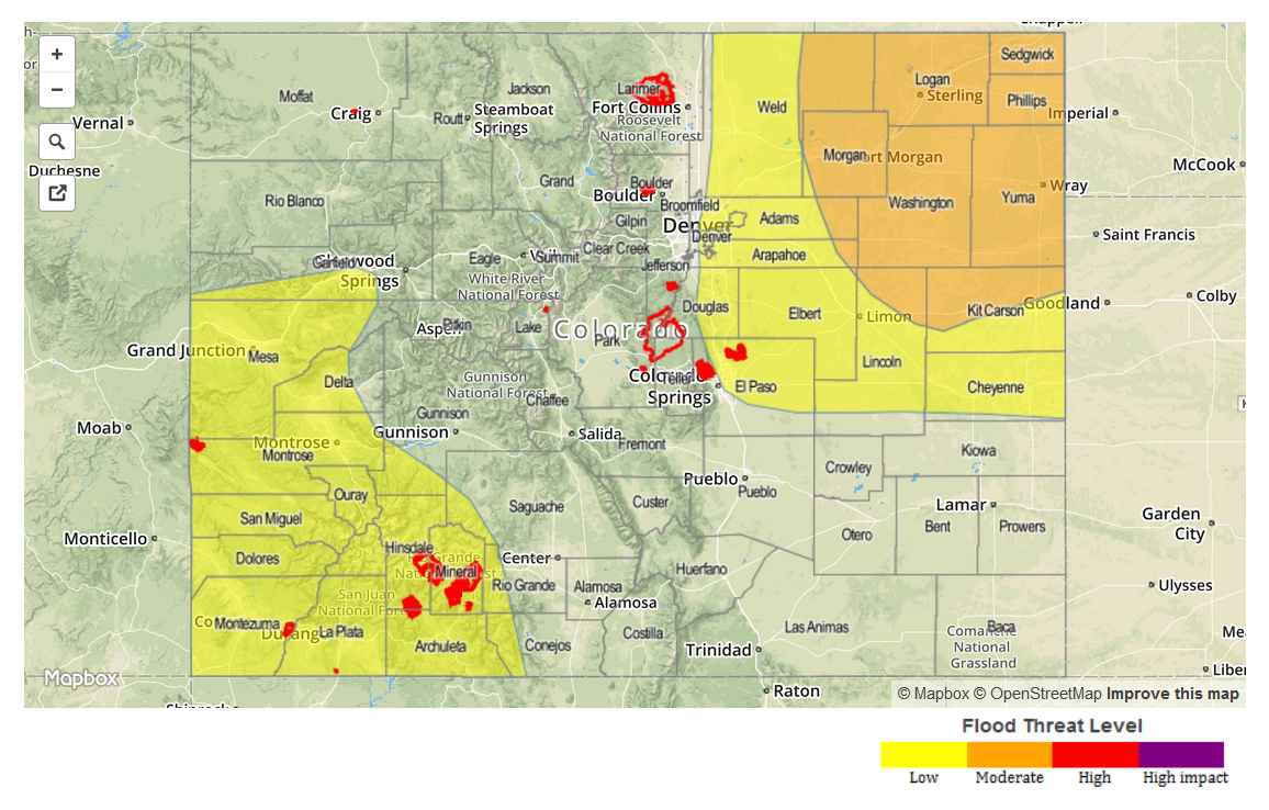
Zone-Specific Forecasts
Urban Corridor, Northeast Plains, Raton Ridge, Palmer Ridge, and Southeast Plains:
Scattered strong-to-severe thunderstorms expected across the Northeast Plains, Palmer Ridge, and Southeast Plains, with isolated thunderstorms (some strong) expected elsewhere. Maximum rain rates will vary:
Urban Corridor and Raton Ridge: 0.8-1.2 inches/hour
Southeast Plains and Palmer Ridge: 1.2-2.0 inches/hour
Northeast Plains: 2.0-3.0 inches/hour
Timing: 2 PM – Midnight
Northern Mountains, Front Range, Central Mountains, San Luis Valley, Northwest Slope, and Southeast Mountains:
Isolated-to-scattered showers and thunderstorms, but lesser moisture than other regions will keep coverage and rain rates down a bit. Maximum rain rates will be 0.4-0.6 inches/hour.
Timing: Currently – 11 PM
San Juan Mountains, Southwest Slope, and Grand Valley:
Scattered-to-widespread showers and thunderstorms, some will produce locally heavy rainfall. Cloud cover this morning will limit instability this afternoon, especially if it persists into peak heating hours. The depth of moisture suggests efficient precipitation processes will occur, so a low flood threat has been issued. Maximum rain rates will be 0.8-1.1 inches/hour.
Timing: Currently – Midnight, with isolated-to-scattered showers continuing into tomorrow morning.