Issue Date: Thursday, August 12th, 2021
Issue Time: 11:45PM MDT
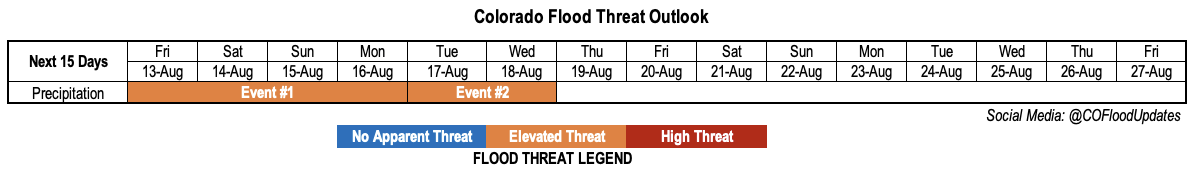
Valid Dates: 8/13-8/27
After a busy stretch of monsoonal rainfall through early August, Colorado went through a dry and warm period over the past 7 days or so. Lucky locations mainly over central and eastern Colorado picked up a few tenths of an inch of rainfall over this time, while very hot temperatures (up to 6F above normal over the Plains) and smoky conditions were the main headlines.
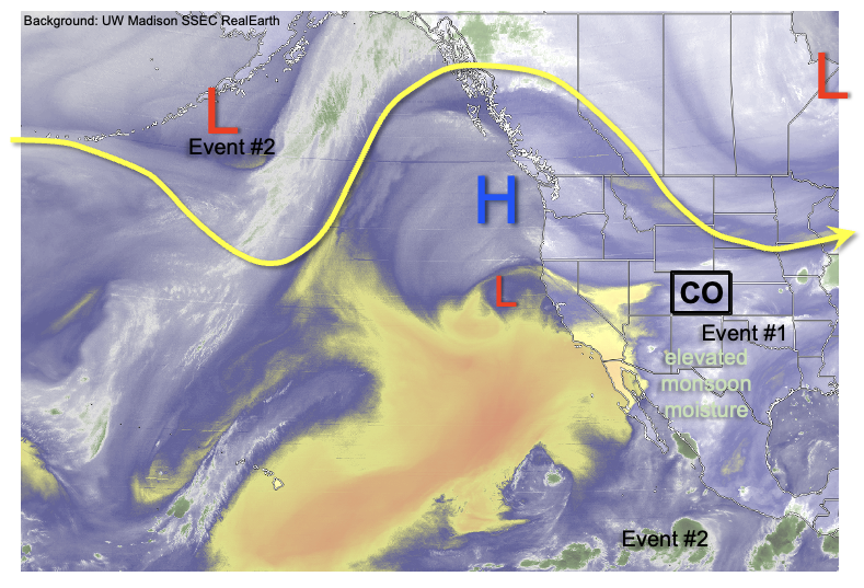
Fortunately, we are still in mid-August, and while average Precipitable Water (PW) has begun its initial seasonal decline from monsoon season, climatology suggests that there is still plenty of chances for rainfall before the drier fall season begins. As shown in the water vapor image, below, this does indeed appear to be the case for the first ~5 days of this Outlook. Moisture, both of monsoonal origin as well as from the Great Plains, has begun to infiltrate into Colorado, and will continue to do so over the next few days. Although the dynamical support for rainfall remains rather subtle, the ample moisture will be enough to support a 4-day period with an Elevated flood threat (Event #1). Scattered to regionally widespread showers and thunderstorms are expected over the course of this time, initially over central and eastern Colorado on Friday, then shifting towards the southwest and southern higher terrain by Saturday through Monday.
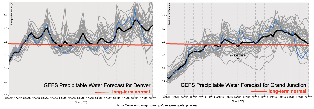
As shown in the forecasted PW plumes, below, moisture will increase even further by the middle of next week, this time statewide. The driving force behind this will be a large-scale trough, currently entering the Gulf of Alaska, that is forecasted to strengthen and move into the Pacific Northwest by late Monday and further east-southeast by Wednesday. Deep southerly flow is expected to develop in advance of the trough passage, which will support a strong moisture surge for Colorado. PW forecasts suggest values as high as 1.2 inches in Denver, which is noteworthy for this time of year. The good news is that widespread rainfall is looking more and more likely for a large part of Colorado with this trough, Event #2.
From the perspective of the flood threat, there are two major wildcards with this feature. First, as seen in the water vapor image, the eastern subtropical Pacific currently has an extreme moisture gradient, with dry air to the east of Hawaii but significant moisture closer to Mexico. If the dry air is pushed far enough east, there will be a strong atmospheric river-type tropical connection for Event #2. This could support moderate to heavy rainfall for longer durations than our typical 1 hour period, say 6-12 hour. The second wildcard is that it is unclear if there will be enough instability to support anything beyond moderate rainfall intensity. This will depend on the exact timing of the trough passage. For example, an early morning passage would constrain instability and lead to widespread moderate rainfall but not much of a flood threat. At this time, as a blend of these possibilities, we are posting an Elevated threat for Event #2. Much more certainty will exist by Monday’s updated Outlook.
After the passage of Event #2, a significant cooldown is expected across the entire state, with temperatures at least a few degrees below normal and limited precipitation chances.
Each of the two identified precipitation events are described in more detail below.
Event #1: Friday – Monday (August 13 – August 16)
Elevated Flood Threat Mainly For Both Higher Terrain And Plains
On Friday, scattered showers and thunderstorms, capable of moderate to heavy rainfall, are expected both over the higher terrain mainly along and east of the Continental Divide, as well as the adjoining foothills and plains to the east. Up to one inch per hour of rainfall intensity is expected over the higher terrain. Isolated heavy rainfall will also remain a possibility further east, especially along the KS border, where intensity up to 2 inches per hour will be possible. However, the coverage over the Plains is uncertain, but currently appears to remain on the isolated side.
By Saturday, and through Monday, most of the activity will shift over the central, southern and southwest higher terrain where scattered to possibly numerous showers and thunderstorms will be likely each afternoon and evening. Isolated rainfall intensity over 1 inch per hour looks like a good bet at this time, which supports and Elevated flood threat. However, with only modest instability available, it does not appear that the threat will be constrained to be only isolated in nature.
Event #2: Tuesday – Wednesday (August 17 – August 18)
Widespread Rainfall Anticipated, But Intensity Uncertain; Elevated Flood Threat Currently Warranted
Widespread rainfall is looking more and more likely for drought hampered parts of the Western Slope, as well as central and southern Colorado. The big uncertainty at this time is whether there will be enough instability to present a flood threat, or whether the rainfall will be more stratiform and lower intensity. At this time, it appears that at least on Tuesday, sufficient instability will exist to support 1 inch per hour intensity over the entire higher terrain. There is more uncertainty on Wednesday, but it is still early enough in August, where climatology does support heavy rainfall likelihood, hence an Elevated threat is extended through Wednesday.
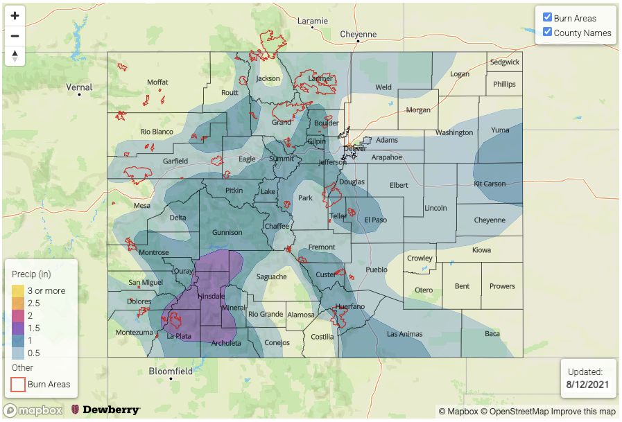
Overall, up to 1.5 inches of rainfall is currently looking possible over the course of this event, likely for areas of the Central and Northern Mountains. This is excellent news for both drought, as well as suppressing any late season wildfire activity.